


![]()
You are here
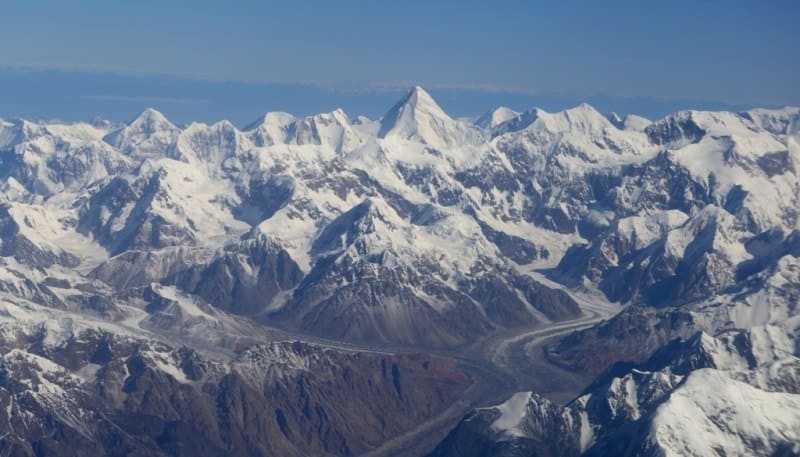
Central Tien-Shan mountains.
Central Tien-Shan Tours in Kyrgyzstan.
“Thought is invisible nature”
Heinrich Heine.
Hiking and travel to Central Tien-Shan.
Central Tien-Shan, part of the Tien-Shan mountain system that covers the Meridional ridge, adjacent from the east a small part of Terskey Ala-Too, the entire Adyrtor ridge, the submeridional ridge Katta-Ashutor. The eastern part of the Sary-Dzhaz ridge, the Tengri-Too ridge, the eastern part of the Inylchek-Too ridge, the entire Kaindy-Katta ridge, the entire eastern part of the Kakshaal-Too ridge to the closing peak on the border of the Kyrgyz Republic and China with a height of 6746 m. a. s. l. and Rapasov Peak (Nameless) with a height of 6814 m. a. s. l., the entire Inylchek-Too ridge, the entire Aktau ridge.
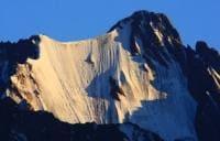
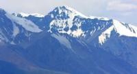
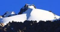
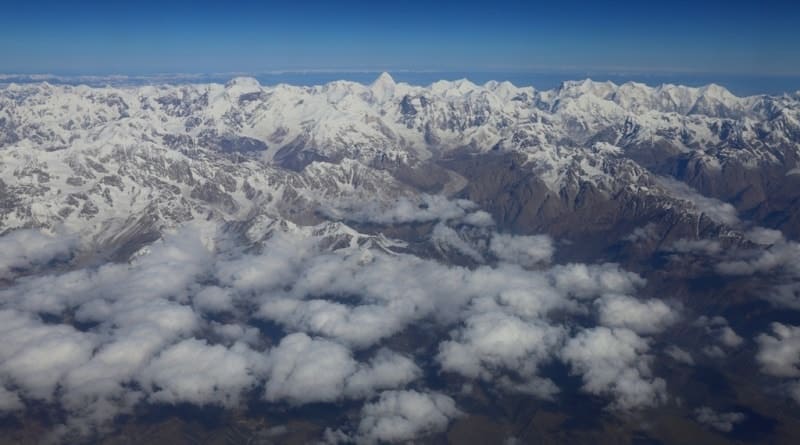
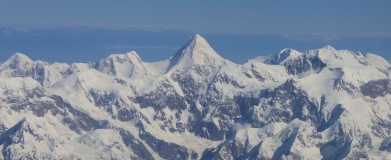
The mountains of the Central Tien-Shan are located on the territory of the Ak-Suu region in the eastern part of the Issyk-Kul region. In the Central Tien-Shan there are the highest peaks of the Tien-Shan - Pobeda peak, 7439 m. a. s. l., Khan-Tengri, 6995 m. a. s. l., there are more than 10 peaks above 6000 m. a. s. l., more than 30 peaks exceed 5000 m. a. s. l.
This area of about 1,300 square kilometers really occupies a central position in the Tien-Shan mountain system and, on the whole, is more of the same type in terms of physical and geographical conditions. The Central Tien-Shan is characterized by the alternation of high mountain ranges and narrow valleys of the latitudinal direction.
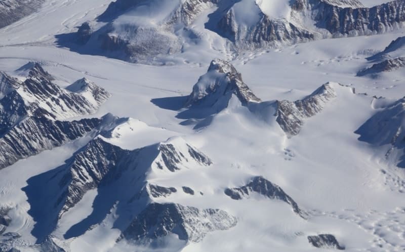
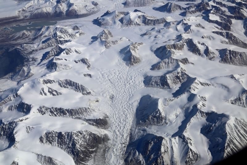
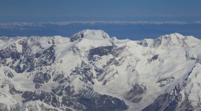
The total area of glaciation is more than 1700 square kilometers, more than 80 glaciers with a length of over 4 kilometers. The largest glaciers are: North and South Engilchek (211 and 583 square kilometers), Kaindy (90 square kilometers), Semyonov (69 square kilometers).
On clear cloudless days, against the background of dazzling white, sparkling snow, the sun shines especially brightly. Here, wherever you look, there are glaciers, firn fields, and snowfields everywhere. In winter and summer, avalanches crash with a roar, raising clouds of snow dust.
Glaciers and firn fields occupy approximately 1/5 of the entire area of the Central Tien-Shan. Huge reserves of moisture are accumulated here in snows and glaciers. Traces of recent glaciation are visible everywhere: moraines, drumlins, boulders, sheep's foreheads, glacial furrows and scars.
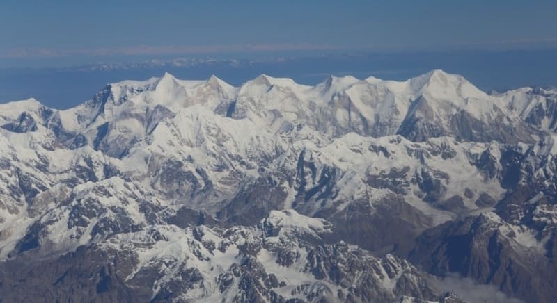
In the upper reaches of many valleys there are firn fields and glaciers that give rise to rivers. On the eastern border of Kyrgyzstan rises the Meridional Ridge, so aptly named for its meridional stretch. Its peaks rise more than 6000 meters above sea level, and the highest of them reaches 6814 m. a. s. l.
The ridge Sarydzhaz departs from it to the west, from which the ridges - Terskey-Ala-Too and Adyrtor - leave to the north-west. Between them lie the upper reaches of the Sarydzhaz and Adyrtor valleys. To the south of Saryjaz, the Inylchek valley stretches, the upper reaches of which are divided into two by a short Sredinny ridge - the North and South, completely occupied by glaciers.
From the Meridional ridge in its southern part to the south-west stretches the highest ridge of Kyrgyzstan and the Tien-Shan - Kokshaal-Too with the peak of Pobeda peak, 7439 m. a. s. l. A number of ridges extend from it to the north-west: Inylchek-Too, Kaindy and others, separated from one another by intermountain valleys - Kaindinskaya, Kuyukapskaya.
The valley of Saryjaz first goes to the west, and then turns to the south, crossing the mountain ranges of Kuilu-Too, Terekty, to which the chains of Akshiirak adjoin in the west. They are separated by the mountain valleys of Sarychat, Kuilyu, Uchkol, Irgash, Cholokkapchagay, wider than Sarydzhaz.
They are usually located at an altitude of more than 3000 m. a. s. l., and only the lower reaches of some of them have marks of about 2500 m. a. s. l. Until recently The Akshiyrak range was considered to be a single mountain range.
There is snow everywhere, glaciers, and the relief was very difficult to understand.
So it was until the 50s, so Akshiyrak was depicted on maps. But the studies carried out by the Tien-Shan high-mountain physical-geographical station showed that Akshiyrak consists of three mountain ranges. It became known that there are 131 glaciers there, and if you count the hillocks of valley glaciers, this number will increase to 150.
Their total area is 432.2 square kilometers. Between the ridges of Kokshaal-Too in the south and the southern chain of Akshiyrak in the north, there is a high-altitude valley of Cholokkapchagay, called Akshiyrak in the lower reaches.
Landforms are quite rare here, especially among limestones.
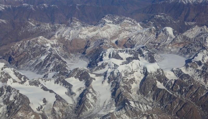
Many glaciers come down to the valley from the slopes of the Kokshaal-Too ridge from the glacial Dzhangart knot. Landscapes are unusually severe and majestic. The surface of large glaciers is torn apart by icefalls; moraine deposits are found on even areas of ice.
Muddy turbulent rivers predominate, crossings through which are very difficult and dangerous. The Central Tien Shan is distinguished by an increased avalanche danger. The most favorable period for tourism is July - August, although winter (February) trips are also possible.
Climate of Central Tien-Shan.
The Central Tien-Shan is cool in summer and cold in winter. In the lower valleys, the average temperatures of the warmest month are slightly above 100, and in January - minus 200, where the glaciers end, they are even lower. Average temperatures in July are only about 50, and in January - minus 220, and even in summer it snows, there are blizzards, snowstorms.
Above 4500 m. a. s. l., eternal cold reigns. The average annual temperature in the syrts is 7 - 8 °C, i.e. lower than in the Pamirs or Novaya Zemlya, and only 2 °C higher than in the Antarctic Mirny. Here, only three months of the year have a positive average temperature, and there is not a single day without frost.
The average daily temperature of the warmest month - July - in the area of the Syrts is + 4.7 °С, in August +3.0 °С. But this is in the syrts, and at an altitude here, as well as in other regions of the Tien-Shan, the temperature drops in summer by 0.7 ° for every 100 m.
And the wind that does not subside day or night. The contrast between the northern and southern slopes of Terskey-Ala-Too is striking. And it manifests itself in the relief, and in the climate, and in the vegetation, and in the animal world. Permafrost is widespread.
The complex physical and geographical processes currently taking place in this region have a great influence on the modern appearance of the emerging landscapes.
Soils in Central Tien-Shan.
Soils in most cases are thin, skeletal. Vegetation often covers only 10 - 15% of the area, and it seems that the process of overgrowing the territory is just beginning. Landscapes of the cold desert or, as they are also called, mountain tundra, high-mountain semi-deserts, and steppes predominate.
In the cold desert, soils are usually stony or clayey (takyr), clay-saline. On relatively dry soils, lichen tundras are developed, on more humid soils, moss ones.
Vegetation of Central Tien-Shan.
Often there are dryadint, ostrich pods, sometimes there are alaki: fescue, feather grass. The general appearance of the cold desert was well described by D. N. Kashkarov: “Sloping, smoothed hills, bare soil, almost not covered with vegetation, more densely overgrown with it only along the banks of lakes and rivers (sazy), numerous “saucers” of lakes, mirrored, although quickly flowing rivers, powerful glaciers surrounding the cold desert from almost all sides, fogs constantly enveloping the surrounding mountains, often flying snow squalls - all this resembles a picture that took place in a remote ice age near the edge of the glacier, so much so that it is about to seem to appear from behind a hill a hairy mammoth and a man with stone tools chasing him.
On the northern slopes and bottoms of the valleys up to a height of 3000 - 3200 m. a. s. l., there are forest areas of Tien Shan spruce and birch forests, desert and syrt vegetation prevails. Wormwood, fescue, ptilagrostis, white bluegrass, feather grass, and feather grass grow in semi-deserts and steppes.
Meadow-steppes, subalpine and alpine meadows, especially cobresia meadows, are often found. Around small lakes there are usually sazes with thickets of sedge. In the lower reaches of some valleys there are forests of Tien-Shan spruce.
Thickets of sea buckthorn, meadowsweet, birch are sometimes seen along the floodplains of the rivers.
The vegetation of the northern slopes of the Terskey-Alatau ridge is quite rich and diverse. On more shady and humid slopes at altitudes from 2100 to 3100 meters above sea level, Tien-Shan spruce (Schrenk spruce) grows, to which Semenov's fir is mixed in places.
Up to an altitude of approximately 2500 m. a. s. l., they are accompanied by shrubs barberry, honeysuckle, currant and wild rose. Above the forest zone - high-mountain subalpine and further alpine meadows with creeping juniper and caragana.
Even higher (up to about 3800 meters above sea level) are patches of alpine meadows, individual plants of chickweed, edelweiss, anemones, mosses and lichens. The vegetation of the syrts is very poor. Its characteristic features are extreme poverty, oppression, rarefaction.
In a thin layer of soil cover lying on the permafrost zone, only plants that are well adapted to the harsh conditions of existence develop. Most of the territory of the Syrts is occupied by sparse steppe and desert vegetation, the smaller part is occupied by alpine meadows, swampy, overgrown with sedge lowlands are found here.
As you rise, this vegetation is replaced by mosses and lichens. Here you can meet argali, snow leopard, marmot, vole and various birds. Natural resources of the Central Tien Shan. The highlands are still used mainly as summer pastures, although there are winter pastures in some valleys.
Cattle are brought here from the Issyk-Kul basin and the Inner Tien-Shan. Recently, fodder grasses have been grown here. Hunting is of some importance, especially the capture of snow leopards, argali and teke for zoos. Now the Central Tien-Shan is connected with the regions of Issyk-Kul and the Inner Tien-Shan by motor roads.
And earlier they got here only on horseback and transported all the necessary goods in packs.
Rivers of Central Tien-Shan.
The rivers of the central part of the Central Tien-Shan belong to the Tien-Shan type and are mountain streams with a fast and turbulent flow. The highest flood occurs in July - early August. The valleys of the rivers flowing along the lateral spurs of the ridge are wide, and the valleys of the transverse tributaries are narrow.
Water, as a rule, is clean and transparent, with the exception of the largest rivers, in particular the Irtash. Crossing the rivers Terskey-Ala-Too, Kuilyu and Akshiyrak are usually quite difficult and require appropriate training, knowledge, time and effort. Syrt rivers have a calm flow and a well-developed delta. Crossing them is usually easy.
Tourism and mountaineering in Central Tien-Shan.
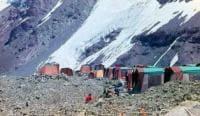
For a long time, very little was known about the Central Tien-Shan, although it attracted many brave travelers with its fame and natural features. Perhaps the most convenient mode of transport here is a helicopter. From a height, the entire hard-to-reach mountainous area is clearly visible.
A special attraction is the marble pyramid of Khan-Tengri Peak, the unique pulsating Merzbacher Lake, the water from which periodically flows through the ice channels of the Northern Inylchek glacier into the Southern Engilchek River.
The Central Tien-Shan is an area of predominantly mountain tourism and mountaineering.
Difficulties of tourist routes attract the most qualified sportsmen here. The Central Tien Shan is distinguished by an increased avalanche danger. The most favorable period for tourism is July - August, although winter (February) trips are also possible.
About 80 classified passes are known, of which more than 30 passes are from 4000 to 5964 m. a. s. l., the lowest classified pass is Kokpak, 3200 m. a. s. l. There are more than 10 simple cattle passes with a height of 3000 - 3800 m. a. s. l. Approaches along the valley of the Bayankol river with a length of more than 50 kilometers, along the valleys of the Sary-Jaz, Engilchek, Kaindy rivers - about 40 kilometers.
The climbing season for climbing peaks above 6000 meters is July-August, for peaks up to 6000 m. a. s. l. the season also includes September. This is one of the harshest regions of the Tien-Shan. Normal weather in summer, when the morning sun gives way to clouds by noon, and it snows in the afternoon.
Sometimes the weather deteriorates for several days and it can snow for 2 - 3 days without stopping. The most stable weather is set in August and lasts until mid-September, but in September it becomes much colder than in August.
The average temperature in July is 5°С, in August 7°С and in September 3°С.
Routes in the area are combined, snowy and snow-ice. The slopes and peaks of the mountains are covered, as a rule, with snow and ice. In addition to the technical difficulties that may be encountered on the route, climbers are in danger: the weather, which can suddenly deteriorate for several days, after which the path traveled can become avalanche-prone and cracks in the glacier, which are very insidious in this area.
As a rule, after long snowfalls, it takes 1-2 days for the snow to consolidate.
Geographic coordinates of Central Tien-Shan in Kyrgyzstan: N42°10'36 E80°00'19
Authority:
"Kyrgyzstan". Publishing house "Thought". Moscow city. 1970 The book "Soviet Encyclopedia". Mountaineering regions of Kyrgyzstan, guidebook, author Vladimir Komissarov. Bishkek, 2010.
Photos by:
Alexander Petrov.