


![]()
You are here
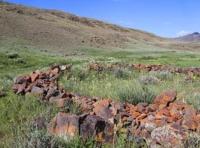
Burial ground Kyzyltas.
Boat trip on Bukhtarma reservoir.
“I've known rivers ancient as the world and older than the flow of human blood in human veins. My soul has grown deep like the rivers”
Langston Hughes.
Take a trip to town Kurchatov and Altai.
Kyzyltas burial ground is located at an altitude of 501 meters above sea level, located on left bank of stream, which is left tributary of Urunkay (Sibinka) River, at foot of northern slope of Mount Soroka, 805 meters above sea level, in Kalba Mountains, 1.4 kilometers west of left bank of Urunkai (Sibinka) River, 5.1 kilometers south and slightly west of village of Sagyr (former village of Leninka), 5.3 kilometers southeast of village of Besterek, 33 kilometers south of town of Ust -Kamenogorsk, in Ulansky district, in East Kazakhstan region.
At the north-eastern slope of Sorokina Mountain, the Kyzyltas burial ground is located. Monuments from the Bronze Age to the early Middle Ages have been recorded here. The bulk of the mounds and fences were studied by F.Kh. Arslanova (1972), G.A. Kushch (1980), G.I. Suvorova (1990), A.A. Tkachev (1992).
In the 30s of the last century, the famous archaeologist S.S. Chernikov noticed and quickly reported on mound groups in the area of the village of Leninka, next to which the Ak-Baur tract is located. The obtained material is stored in the funds of the regional historical and local history museum of Ust-Kamenogorsk.
Three mounds with “mustaches” occupy a special place at the burial ground. Mounds with “whiskers” are mounds with two or one stone ridges directed to the east, less often to the south. On the northern wing of the mound field there is a mound with “whiskers” with long hundred-meter ridges of stones radiating from the main embankment to the east.
The arrow of the monument pointed to the west – to the square Mount Karabas. Most archaeologists consider mounds with “mustaches” to be funerary and memorial monuments. Some researchers propose to consider them as archaeoastronomical objects, oriented with their points and elements to certain planets and luminaries located at specific points in the sky at specific moments in time.
There is no unity in determining the chronology of mounds with “mustaches.” A variety of dates are proposed, ranging from the 6th century BC to the mid-1st millennium BC.
Geographic coordinates of Kyzyltas burial ground: N49°40'30 E82°38'06
Authority:
The board in the natural boundary Akbaur. June, 2017. Evgeny Kurdakov of "Ak-Baur of a secret and opening". Ust-Kamenogorsk, 2008.
Photos by:
Alexander Petrov.