


![]()
You are here
Big Almaty Lake.


Trip to Big Almaty Lake.
"On the shore of an alpine lake, located at the foot of a mountain covered with dark fir trees, the bright and rich green color of the water makes me exclaim:
"Absurd! This color is exactly the same as the tiles in the bathroom. There is something unhealthy about this color."
Everything turned out as I said. Not a single fish decided to choose to live in these strange waters. The first dwelling we encounter is a modern chalet built for use by lumberjacks. In the vast space, the endless steppes are visible in the distance, stretching to the vast Siberian swamps, where only the plain reigns."
Ella Maillart. "Turkestan Solo" (Let from Lake Issyk-Kul to Alma-Ata). 1932.
Big Almaty gorge Walking.
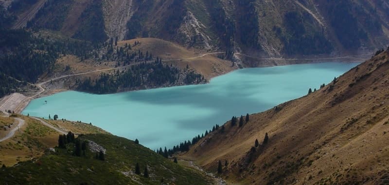
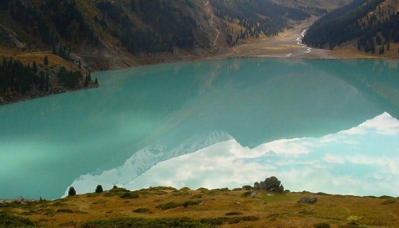
Flowing, fresh Big Almaty Lake, located at an altitude of 2511 m. a. s. l., located in bed of river of same name, in northern part of Almatynin-Alagyra mountain spur, on northern slope of Zailiskiy Alatau, on territory of Ile-Alatau natural park in Bostandyk district of Almaty.
The largest in the Zailiskiy Alatau ridge is the moraine-dammed Big Almaty Lake, formed from the blocking of the Bolshaya Almatinka River valley by an ancient frontal moraine and a large landslide. The core of the dam consists of porphyry rock. The height of the dam is about 500 meters, the length is about 1000 meters, the width is 500 meters.
The maximum depth of the lake is 38 meters, the volume of water is more than 13,000,000 cubic meters. The water is clean, fresh and cold. The amplitude of fluctuations in the water level in the lake reaches 111 cm. The lowest level is in March, the highest is in July - August during the period of intense melting of glaciers.
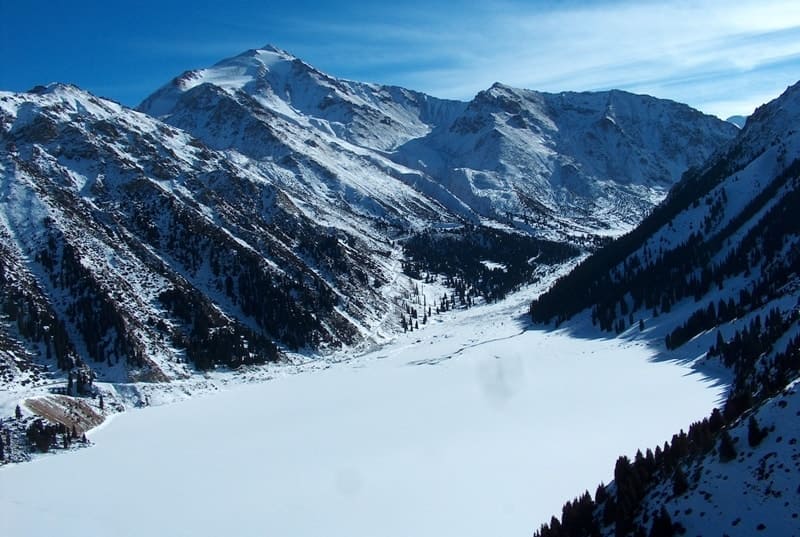
In winter the lake freezes. The lake is fed by the waters of the Bolshaya Almatinka River, the sources of which are located in glaciers 12 kilometers south of the lake. A pipeline emerges from the lake, on which a cascade of hydroelectric power stations is built.
Located 25 kilometers from the city of Almaty, Big Almaty Lake attracts with its beauty, steep banks, steep cliffs, moraines and glaciers. History of Big Almaty Lake. Previously, the lake was called Zhosalykol, then for a short time at the beginning of the twentieth century - Almaty, and later acquired its current name, which determines its location in the Big Almatinka River basin.
The dam of the lake was formed by an ancient glacial moraine and a huge collapse of the adjacent slopes, which created a natural dam. Until the end of the 40s of the last century, a river with beautiful cascades of waterfalls flowed from the lake through the top of a natural dam. In the early 50s, the river flowing from the lake was partially taken into a pipe that supplied water to the turbine blades of the hydroelectric power station cascade.
At the end of the 70s of the last century, the natural dam was strengthened with reinforced concrete; in the 80s of the last century, periodic repairs of the dam were carried out by Kazglaselezaschita. The length of the lake from southwest to northeast is 982 meters, the greatest width in the central part of the lake from east to west is 580 meters (data as of October 14, 2020).
The perimeter of the lake reaches 2570 meters, the area is 0.35 square kilometers (data as of June 10, 2021). In spring and summer, water fills the lake, which is necessary for the operation of the cascade of hydroelectric power stations located in the valley of the Bolshaya Almatinka River.
The lake is filled to its maximum level by November 1 for the uninterrupted operation of the hydroelectric power station cascade during the winter period. Fluctuations in the water level in the lake reach 20 meters. In winter, the lake freezes and is partially drained through water intake pipes.
The maximum water level is in August, the minimum in February. The maximum water temperature is 12.8 ° C. At an altitude of 2511.2 meters above sea level, the Bolshaya Almatinka River flows into the lake from the southeast with a delta wide up to 450 meters.
The river flows from the lake through two underground watercourses, 450 and 490 meters long, overcomes natural and artificial dams and flows in one channel at an altitude of 2375 m. a. s. l. The Serke-Bulak stream, 3.8 kilometers long, flows into the northwestern part of Big Almaty Lake.
The stream originates from the northern slopes of the Almatynin Alagir ridge and from the eastern slope of Mount Tourist with a height of 3954, 2 meters above sea level, part of the water flows from the cirque glacier and is replenished with the partial melting of the snow of the eternal glaciers.
Geographic coordinates of Serke-Bulak stream: N43°02'59 E76°57'58
The lake offers picturesque panoramas of the surrounding mountains. In the south-eastern side of the lake rises Sovetov Peak, 4317 meters above sea level. In the south you can see the dome-shaped snow-ice peak Ozernaya with a height of 4130.5 m. a. s. l., in the southwest of the lake there is Mount Tourist with a height of 3954.2 m. a. s. l.
From the west, the lake is closed by the Bolshoi Almatinsky peak, 3681.9 m. a. s. l., which is clearly visible from Almaty with a beautiful pyramid in the south. The lake serves for drinking water supply to Almaty and is part of the city’s water management system.
There is an asphalt road from the city to the lake. There is a gauging station in the southeastern part of the lake at an altitude of 2545.3 m. a. s. l. In the northwestern part of the lake there are houses of the Institute of Geography of the Academy of Sciences of the Republic of Kazakhstan.
Geographic coordinates of Lake Big Almaty: N43°03'12 E76°59'01

Authority and photos by:
Alexander Petrov.