


![]()
You are here
Big Almaty Gorge.
Tours to Big Almaty Gorge.
“It is untrue that equality is a law of nature. Nature has no equality; its sovereign law is subordination and dependence”
Luc de Clapiers de Vauvenargues.
Sights in Big Almaty Gorge.
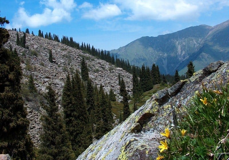
Big Almaty Gorge is located in bed of river of same name, on northern slope of Zailiyskiy Alatau, on territory of Ile-Alatau natural park in Bostandyk region of city of Almaty.
One of the most attractive, accessible and frequently visited places. The first kilometer post on the way to the gorge is located at the intersection of Al-Farabi Avenue and Navoi Street, it has No. 13/33, that is, 13 kilometers from the city center and 33 kilometers up the gorge, an asphalt road is laid through all high-altitude zones.
The road begins on the southern outskirts of the Orbita microdistrict. The first full house on the way to the gorge was installed at an altitude of 992 meters above sea level. This road ends at the Zhosalykozen pass, 3336.8 meters above sea level, where the Institute of High Energies of the Academy of Sciences of Kazakhstan is located, or Cosmostation, as Almaty residents are used to calling it.
From the city to the gorge for the first seven kilometers there is a wonderful wide asphalt road along a slightly inclined alluvial cone of the Bolshaya Almatinka River. After the "Zhol police" checkpoint, there are a large number of cafes and restaurants on the right and left in the gorge, which began to be built in the early 2000s.
On the right and on the left, the area is adorned with gardens, among which the bowl of the Orbita television station, which receives transmissions from artificial earth satellites, is picturesquely looming. The sloping plain gives way to relatively steep ridge and foothill hills - "counters".
They are covered with large tracts of gardens of the Alatau village. At the sixth kilometer at an altitude of 1250 m. a. s. l. from the main road to the Big Almaty Gorge, an asphalt road runs eastward across the river to the mountain slopes of "counters".
This road connects with another that leads into the city through gardens and villages. Here, in the mountains at an altitude of 1270 m. a. s. l.l, the final stop "GES-2" of the shuttle bus. Then the rise increases and gradually passes to steep slopes through the high-mountainous jailau Kokzhayalu in the direction of the Small Alma-Ata gorge.
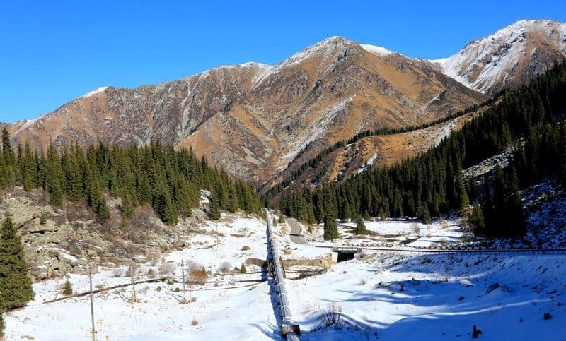
In winter, the river valley is damp and cold - cold air flows down from the mountains. Nearby, on the slope of the northwest exposure, it is warmer and drier. On the sixth kilometer from the outskirts of the city, the road becomes steeper.
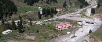
A catastrophic mudflow took place in the gorge in August 1977, which was delayed by a dam built in the riverbed.
The Big Almaty Dam is located at an altitude of 1284 meters above sea level. The construction of the dam began in 1976 and ended in 1980, the height of the dam is 40 meters, the total length along the ridge is 422 meters. The dam contained the catastrophic mudflow that threatened the city on August 3, 1977.
Mud splashed out from the right tributary of the Big Almaty - the Kumbel-Su River. On the seventh kilometer there are “counters” made of sedimentary rocks (loesslike loams). Relatively gentle slopes, pass into the main ridge of the Zailiyskiy Alatau, deep gorges, very steep rocky slopes, talus and rocks.
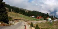
On this border of the transition of the foothills to the main mountain range, at a distance of 2 kilometers from the dam at an altitude of 1320 meters above sea level, there is a forestry and a village of power engineers of HPP-2. Here and a little higher, the asphalt highway forks in three directions, each of which leads to the mountains.
To the left, in a southeastern direction, an asphalt road leads to the Kazashka gorge, where hotels, guest houses are located, and at the end of the gorge the hotel "Kumbel". Where the road ends, the trail begins, which leads to the Kokzhailyau tract and further to the Small Almaty gorge.
Directly up the left side of the floodplain of the Big Almaty River, an asphalt road leads to the Bolshoy Almaty Lake, located at an altitude of 2511.2 m. a. s. l., then to the GAISH observatory and ends at the Zhosalykozen pass, where the Cosmostation is located.
Slightly to the right in the southwest direction, an asphalt road 4 kilometers long goes to the Alma-Arasan tract in the Prokhodnoye gorge. The longest, leading to the lake and the sky-high peaks, is the middle road. The floodplain of the Bolshaya Almatinka River and the hilly "counters" are fully developed and occupied by large tracts of mountain gardens.
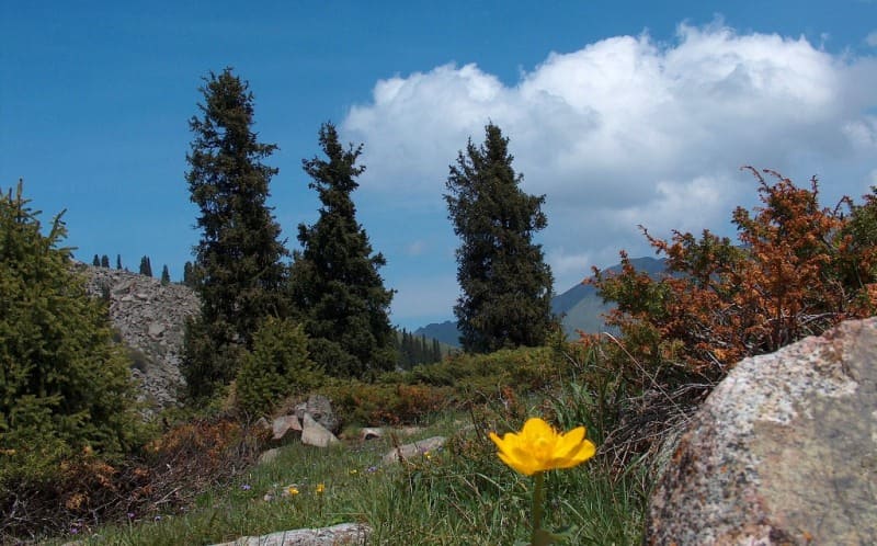
At altitudes of 1000 - 1300 m. a. s. l., the most favorable conditions for gardening, especially for growing the famous Alma-Ata aport. In some places in the floodplain of the river, the wild Sivers apple tree, wild apricot, wild rose, poplar, barberry and hawthorn have been preserved. On the eighth kilometer, at an altitude of 1320 m. a. s. l., the first spruces are found.
The floodplain of the river in the area of "counters" narrows to 50 - 100 meters, thickets of apple, apricot, hawthorn, willow, poplar and aspen grow in it. On the northern slopes of the mountains below there is an apple tree and an apricot, then - Tien Shan birch and aspen, then aspen and birch spruce forests, and even higher are moss spruce forests.
On the southern slopes, individual apricot trees, rose hips, spirea and ephedra bushes grow, higher - creeping juniper cushions. Despite the general dryness and rockiness of the southern slopes, in comparison with the northern shaded slopes, they are also affected by vertical zoning: in the lower part of the mountains there is dry steppe that burns out in summer, in the middle - meadow-steppe, in the upper - subalpine meadows with cushions of creeping juniper.
Further on both sides of the road there are rocks and talus on very steep slopes.
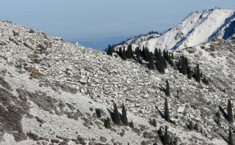
At an altitude of 1420 m. a. s. l., a tenth kilometer from the beginning of the gorge, the kingdom of wild mountains begins, even steeper slopes overgrown with birch and aspen with an admixture of Schrenk spruce, and pure spruce plantations as the height of the terrain increases.
17 km from the outskirts of the city (30 km from the city center), in a gorge at an altitude of 1950 m. a. s. l., there is a strip of clean spruce forests - moss, mountain ash and willow. The belt of deciduous forests of apple, apricot, barberry, aspen and birch remained below.
Then the road turns off the floodplain to the southeast and goes along the side of the mountain. A very steep road leads to the Big Almaty Lake, which from the river floodplain goes to the steep eastern slope. Around rocks, talus and moraine deposits.
Schrenk spruce grows on them in extremely unfavorable conditions. There is a wide view of the mountains both up and down the gorge. Further, the road passes near the alpine rose hotel, located at an altitude of 2200 m. a. s. l., 34 kilometers from the city center.
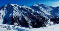
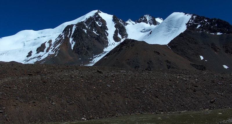
After 3 kilometers, at an altitude of 2240 m. a. s. l., the road winds along a moraine that blocked the gorge. Around on the slopes there are stunted rocky spruce forests, in the lower part near the road - spruce forests on moraines. From an altitude of 2450 - 2500 m. a. s. l. in the Big Alma-Ata Gorge, a high-mountainous treeless moraine landscape begins.
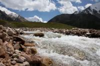
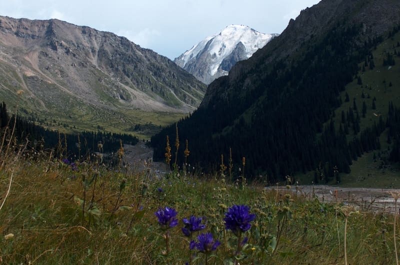
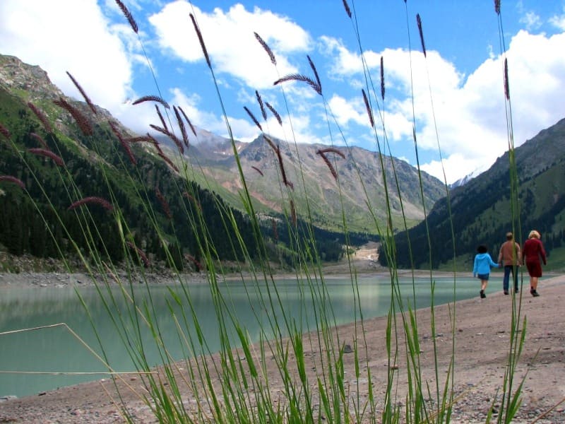
38 kilometers from the city center (25 kilometers from the beginning of the gorge), at an altitude of 2500 m. a. s. l., lies the Big Almaty Lake, very cold, up to 35 meters deep. The water is crystal clear, glacial, blue-light green in clear weather. The river of the same name flows into it from the southeast.
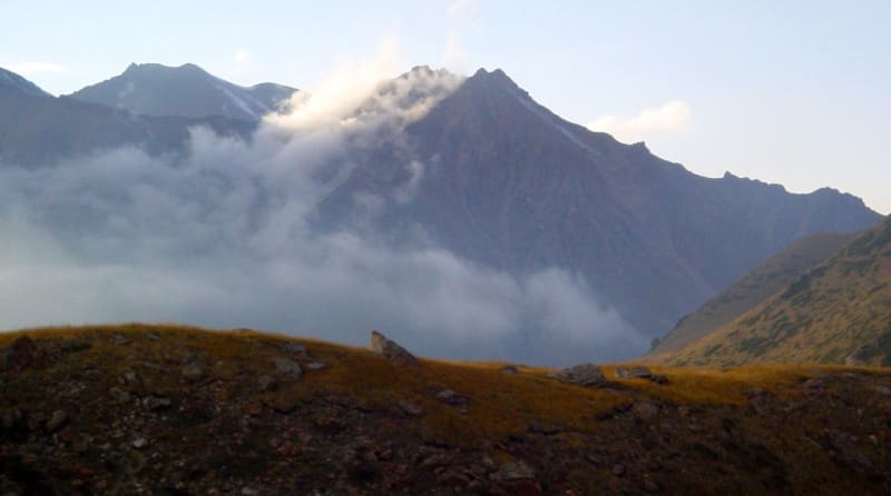
Around the lake there is a completely wild, peculiar beauty: moraines, talus, rocks, individual low-growing spruces and cushions of creeping juniper among the spots of a barely noticeable low alpine meadow against the background of steep slopes, glaciers and peaked mountain peaks.
It is always cold near the lake. Even when the weather is hot in Almaty, it is very cool here and the temperature rarely rises above 5 - 10 degrees Celsius. The feeling of coldness is intensified by icy winds descending from the mountains.
Only 25 kilometers drive through the gorge, and the climate varies from hot to cold, which happens in summer on the coast of the Arctic Ocean.
In such conditions, there are no flies or mosquitoes that disturb people and animals in the foothills. From the lake, the road turns to the south-west and after 2.5 kilometers along a very steep ascent it goes to the State Astronomical Institute named after Stemberg (GAISh), located at an altitude of 2750 m. a. s. l.
The forest remained below, around a wild mountainous rocky landscape with very steep slopes with spots of alpine meadows. A small village of astronomers is conveniently located on an ancient moraine, around which there are very steep slopes with trough-shaped trays from avalanches.
From here, a breathtaking panorama of the lake, moraines, glaciers, rocks and talus opens up. Another seven kilometers of a very steep climb, and the road ends at the Cosmostation at an altitude of 3336.8 meters above sea level. If below to the forest belt rocks and talus alternated with juniper cushions and a low-growing alpine meadow, then in most cases there is no longer any vegetation, only here and there small lawns and rocks covered with a layer of lichens.
It's always cold at this altitude. If the temperature in the city is 15 - 20 degrees Celsius, then it often snows at the Cosmostation. For a healthy person, such an altitude is almost not felt, but the icy wind from the mountains and low temperatures are quickly driven down to warmer and more windless places.
Above Big Almaty lake passes on the way to the beautiful blue lake Issyk-Kul, but at this time the way there is closed - the border zone. Despite the cold, high mountains and steep climbs, many Almaty residents go on foot to the Big Almaty Lake to breathe in the clean mountain air and admire the wild nature.
A dam was built in the river valley, a cascade of 7 hydroelectric power plants. In the south and southeast, it is closed by the main ridge of the ridge, which here strikes to the northeast. Small amounts of glaciation are observed in lateral gorges and carats.
There are fourteen glaciers in total. Of these, on the western (Kargalinsky spur) - eight (including two buried) with a total area of 3.7 square kilometers, (on the main ridge - five glaciers with a total area of 3.2 square kilometers and the western slope of the Bolshealmatinsky spur) - one with an area 0.3 square kilometers.
None of the glaciers has their own name. P. A. Cherkasov designated all of them, with the exception of those buried, with numbers from 1 to 12. By type, they belong to the tar glaciers, hanging glaciers, partly to the hanging valleys glaciers and slope tail glaciers.
There are no valley glaciers among them. The largest are glaciers No. 3, 11, 1. The total area of all glaciers of the Prokhodnaya River, together with firn fields and buried parts, is 7.2 square kilometers. The basin of the right branch of the Bolshaya Almatinka - cuts deep into the main ridge.
The size of glaciation in it is much more significant than in the upper reaches of the left branch. Four more or less isolated glacial groups are distinguished here. The first of them is located on the slope of the main ridge between the western side spur and the main source of the river.
This part of the main ridge does not exceed 4000 meters above sea level. For the first 7 kilometers from the west, it has a northern exposure, and then, due to the rotation of its axis to the south, takes an eastern exposure. The northern slope of the ridge falls steeply into a wide valley filled with ancient moraine deposits.
This valley originates from the saddle of a lateral spur that separates the basin of the left branch of the river from the basin of its right branch. Once the saddle was occupied by a loose glacier. At present, there are moraine deposits in its place.
On the northern slope of the ridge with the highest peak at 4243 meters above sea level, and on average, not exceeding 4000 meters above sea level, six glaciers with a length of 0.5 to 1.5 kilometers lie in short and steep gorges. Their ends, with the exception of one, do not reach the valley.
The same glacier that descends into the valley is distinguished by a greater length (up to 2 kilometers). It is located near the turn of the ridge to the south. In its entire middle and lower reaches, it is covered with continuous moraine deposits. This circumstance gave him the ability to withstand the contraction experienced by other glaciers.
Under the cover of moraine sediments, it slowly moves forward. It lies with a large and high rampart among the old overgrown hills of the valley. For its characteristic appearance, this glacier was named "Moraine". The part of the main ridge curving to the south with a slope facing east bears 5 cara and hanging glaciers.
The total area of glaciers of the first group does not exceed 7 square kilometers. The second glacial group is located in the southeastern part of the basin. Some peaks rise here to an altitude of 4400 meters above sea level and more. The slope is cut by wide gorges.
Some of the latter are well-designed punches. Glaciers of the second group, due to the high altitude of their firn fields, are the most significant in the river basin.
Geographic coordinates of Big Almaty gorge: N43°05'11 E76°58'03
Authority:
"The nature of the Zailiyskiy Alatau", M.Zh. Zhandayev, ed. Kazakhstan, Alma-Ata, 1978 "Along the Northern Tien Shan", V.N. Vukolov, Moscow, Profizdat, 1991.
Photos by:
Alexander Petrov.