


![]()
You are here
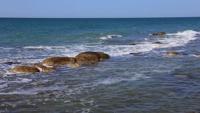
Bay Koshak.
Information about Mangystau.
“For food for the next months, your honor will send monthly camels with your detachment from the coal mining site to the Kochak Bay, where it will be delivered by mail ships or by the Kama steamer and unloaded ashore at a convenient place where it will be stored under guard of a special team, which has to be decked out from the Novopetrovsky fortification consisting of one officer, one non-commissioned officer, 25 privates of infantry".
"From the prescription of the commander of a separate Orenburg corps to Lieutenant Antipov dated March 28, 1851, No. 309."
Environment in Mangystau.
The Koshak (Kochak) bay is located in the north and north-eastern part of the Mangyshlak peninsula, in the east of the Mangyshlak bay and in the north-eastern part of the Tyub-Karagan peninsula in the Tyup-Karagan region in the Mangistau region.
The northern coast of the bay is low-lying with shallows. A chain of mountains stretches along the southern coast, crossed in places by small ravines and a vast valley located in the mountains of Ushayz and Myrzatai.
The length of the bay from west to east is 24.6 kilometers, the width in the central part is 11.1 kilometers. The depths of the bay are from 0.3 meters in the east and up to 4.5 meters in the western part. The Kumberliksor salt marsh adjoins the northern and northeastern parts of the bay, and the Uzynaral tract to the northwestern part. In the central part, from the south, the Karakabak ravine goes out to the shores of the bay.
Local residents have a legend about the Koshak Bay:
"... In very ancient times, two clans - salor and ozhak - were mortally hostile to each other. Incessant wars were fought between them for pastures and water. Finally, it was decided to end the bloodshed, to decide everything with peace.
However, the Salors broke the agreement and cunningly killed the batyr Kochak, the leader of the Ozhak clan. Kochak was buried near the bay, at this place and now there is a cemetery, as well as the famous kuduk (well). Since then, the bay, the tract around it, the cemetery and the well - all this began to be called after the batyr.
Outraged by the insidiousness and unheard-of treachery of the Salorians, aksakals of all kinds gathered at a large council, where they decided to subject them to severe punishment. A huge army gathered in the Tartaly-Turaly tract and utterly defeated the traitors, and the entire Salor clan was forced to leave these lands forever".
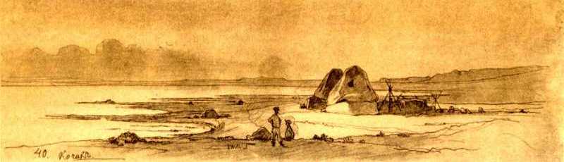
T.G. Shevchenko made a drawing of the Kochak Bay in 1851. There was a pier on the southern shore of the bay in the XVIth century. By order of the commander of the separate Orenburg corps, this place was designated as a base for the supply of food products to the expedition:
“For food for the next months, your honor will send monthly camels with your detachment from the coal mining site to the Kochak Bay, where it will be delivered by mail ships or by the Kama steamer and unloaded ashore at a convenient place where it will be stored under guard of a special team, which has to be decked out from the Novopetrovsky fortification consisting of one officer, one non-commissioned officer, 25 privates of infantry".
Geographic coordinates of the Koshak Bay: N44 ° 33'41.90 "E51 ° 24'23.18"
Authority:
http://www.t-shevchenko.name
http://www.elarna.net/kitap_kk.php?id=3675&oku=23226
Alexander Petrov.
Photos by
Alexander Petrov.