


![]()
You are here
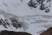
Aylyama glaciers in Kuilyu-Too ridge.
Traveling in valleys of Kyrgyzstan.
“The most enjoyable thing about hiking is the rest.”
Trip along rivers on Kyrgyzstan.
Ailyama glaciers are located on eastern slope of Kuylyu-Too ridge, in area between Uchkel and Kuylyu rivers, in upper reaches of Terekty River, in Ak-Suu region, in southeast of Issyk-Kul region. Aylyama and Aylyama South glaciers serve as the main sources that form the Terekty River. The Terekty River, 28 kilometers long, is the left tributary of the Saryjaz.
In the upper reaches of the river there are 3 glaciers: Ailyama, Ailyama North and the Terekty glacier, located on the eastern slope of the Kuilyu-Too ridge.
Aylyama Glacier. The Ailyama glacier consists of two branches and are located in the center of the glaciation of the Kuylyu-Too ridge on the northern slope of the Terekty gorge. The area of the glacier is 8.99 square kilometers, the perimeter of the glacier reaches 15.26 kilometers.
The length of the glacier is 5.87 kilometers. The upper boundary of the glacier is located at an altitude of 4930.9 and 4891.2 meters above sea level. The end of the glacier is located at an altitude of 3859 meters above sea level.
Geographic coordinates of Ailyama glacier: N42°00'40 E78°44'22
Aylyama North Glacier. The glacier consists of three branches and is located in the center of the glaciation of the Kuilyu-Too ridge on the northern slope of the upper Terekty gorge. The area of the glacier is 6.69 square kilometers, the perimeter of the glacier reaches 22.39 kilometers.
The length of the glacier is 5.11 kilometers. The upper boundary of the glacier is located at an altitude of 5088, 5040 and 4899 meters above sea level. The end of the glacier is located at an altitude of 3672 meters above sea level.
Geographic coordinates of Aylyama North glacier: N42°02'37 E78°45'21
Authority photos by
Alexander Petrov.