


![]()
You are here
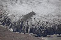
Ashu-Tor glacier, Kuilyu river basin.
Glaciers on Terskey Ala-Too in Kyrgyzstan.
“My work on Asian geography led me... to a thorough acquaintance with everything that was known about inner Asia. I was especially attracted to the most central of the Asian ranges - the Tien Shan, on which no European traveler had yet set foot...”
P. P. Semenov-Tyan-Shansky.
Trip on glaciers in Kyrgyzstan.
Ashu-Tor glacier is located at an altitude: upper boundary of glacier is at an altitude of 4604; end of glacier is at an altitude of 3894 meters above sea level, located on southern slope of Terskey Ala-Too ridge, in upper reaches of Ashu-Tor river, a tributary of Kuylyu River, in Kuylyu river valley in Ak-Suu district, in southeast of Issyk-Kul region.
The sources of the Ashu-Tor River begin with three glaciers: Ashu-Tor Left, Ashu-Tor Right and Ashu-Tor South-East. In the eastern part of the glacier, in the watershed ridge, there is the Kuilyu Pass, 4303 meters above sea level.
Glacier Ashu-Tor Left. The area of the glacier is 1.07 square kilometers, the perimeter of the glacier reaches 5.63 kilometers. The area of the glacier is 1.07 square kilometers, the perimeter of the glacier reaches 5.63 kilometers. The length of the glacier is 2.3 kilometers. The upper boundary of the glacier is located at an altitude of 4604 meters above sea level.
Geographic coordinates of Ashu-Tor Left glacier: N42°03'51 E78°36'25
Glacier Ashu-Tor Right.
The area of the glacier is 5.18 square kilometers, the perimeter of the glacier reaches 13.45 kilometers. The length of the glacier is 5.07 kilometers. The upper boundary of the glacier is located at an altitude of 4636 meters above sea level.
Geographic coordinates of Ashu-Tor Right glacier: N42°03'17 E78°37'23
After 7.3 kilometers from the beginning of its sources, the Ashu-Tor South tributary, 6.8 kilometers long, adjoins the Ashu-Tor River on the left. The sources of the tributary begin from the Ashu-Tor South-Eastern glacier. The area of the glacier is 5.65 square kilometers, the perimeter of the glacier reaches 18.75 kilometers.
The length of the glacier is 3.27 kilometers. The upper boundary of the glacier is located at an altitude of 4455 meters above sea level. In the upper reaches, in the northern part of the river, there are 3 small, moraine lakes.
Geographic coordinates of Ashu-Tor South-Eastern glacier: N42°08'02 E78°35'14
The Ashu-Tor River, 11.9 kilometers long, receives its source from the glacier and is an eastern tributary of the Kuilyu River. At an altitude of 3164 meters above sea level, the river merges with the Karakol-Tor River to give rise to the Kuil. The river's sources begin with three glaciers: Ashu-Tor Left, Ashu-Tor Right and Ashu-Tor South-East. In the eastern part of the glacier, in the watershed ridge, there is the Kuilyu Pass, 4303 meters above sea level.
Geographic coordinates of Ashu-Tor River: N42°06'00 E78°38'27
Authority and photos by:
Alexander Petrov.