


![]()
You are here
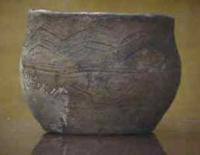
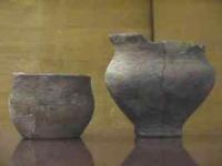
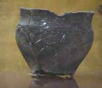
Atasu settlement and burial ground.
Tours to monuments Bronze Age in Central Kazakhstan.
"Fire - a monument to Prometheus"
Alexander Seleznev.
Monuments of Central Kazakhstan.
The Atasu-1 burial ground is located in the Akshoki rural district in the southern part of the Kyzitau mountains, 563 meters north-west of the right (northern) bank of the Atasu river, south of the Mynbay valley, 23.7 kilometers south-west of the Kyzyltau village, 70,4 kilometers north-west of the village of Kiyikty in the Shet district of the Ulytau region of Kazakhstan.
The Atasu-1 settlement is located in the Akshoki rural district in the southern part of the Kyzitau mountains, 987 meters north of the right (northern) bank of the Atasu river, in the southeastern part of the Mynbay tract, 23.9 kilometers south-west of the Kyzyltau village, 70.6 kilometers north-west of the village of Kiyikty in the Shet district of the Karaganda region of Kazakhstan.
Monuments of the Bronze Age of Central Kazakhstan are evidence of the bright and original culture of the tribes of the 2nd - early 1st millennium BC. Monuments of the Bronze Age are concentrated along the banks of the rivers near the mines.
Regularities are seen in the location - large settlements were located on convenient, level sites along the river banks, and small settlements near mines; for burial grounds, elevated places were chosen not far from settlements at a distance of 0.2 - 2 kilometers; settlements and burial grounds were separated by a river bed or a mountain ridge.
The total area of the settlement is over 15,000 square meters. There are 27 large and small depressions in the settlement area, which can be combined into three groups. The first group includes rectangular in plan, sometimes with rounded corners, depressions with an area of 150 - 260 square meters.
They are mainly concentrated around a large “house”. The contours of the depressions are sometimes disturbed by late, rounded dwelling pits. The second group includes depressions, rounded in plan, with an area of 80 - 100 square meters, a depth of 10 - 35 cm, located in several, not far from each other in the central and northern parts of the settlement.
The space between them was used for livestock pens and other household purposes. The third group consists of inconspicuous rectangular and rounded depressions with an area of 20 - 60 square meters, up to 15 cm deep, located in the eastern and western parts of the settlement.
Some of them adjoin dwellings, others are connected to each other by passages, from which small hollows have been preserved. On the area of the settlement, the contours of more than 40 ash pans are clearly distinguished in the form of flat mounds of a rounded shape.
Their diameters reach 3 - 5 meters. Most of the ash pans are concentrated around large depressions. In the eastern part of the settlement, the remains of an ancient dam have been recorded. As a result of studying 12 rounded, 3 rectangular in terms of buildings and 7 copper-smelting complexes, it turned out that the early premises of the settlement had a rectangular configuration and large dimensions. Typical is a rectangular room in the central part of the settlement.
Its walls are composed of vertically installed large granite slabs, buried 25 - 35 cm into the ground. The slabs of the southeastern and partly northeastern walls form a double row. The dimensions of the slabs vary from 1.7 x 0.55 x 0.2 to 2 x 1.55 x 0.2 meters.
The length of the room, oriented with corners to the cardinal points, is 22 meters. Its width in the south-eastern part is 13 meters, in the north-western part - 11.2 meters. The entrance, facing southwest, is 3.6 meters from the northwest corner.
Around room 1, 6 copper smelting complexes are concentrated, consisting of 1 - 4 copper smelting pits with additional structures for carrying out certain operations. Long chimneys extending from the furnaces mainly in the southeastern and northwestern directions performed various functions: they provided air draft from the furnaces, heating the room, and firing ceramic vessels.
Copper-smelting complexes are of two types; without building and with building. The first is an open area of 100 - 160 square meters, where several copper smelting furnaces are concentrated. Remains of ground structures are not recorded here. In copper-smelting complexes with the construction of the furnace, they are partly indoors and partly outside.
Long chimneys of the stoves run along the walls of the premises, thereby heating it. Such complexes can be called metal workshops.
Geographic coordinates of Atasu 1 burial ground: N47 ° 48'03.48 "E72 ° 04'26.04"
Geographic coordinates of Atasu ancient settlement: N47 ° 48'17.26 "E72 ° 03'37.23
Authority:
"Archaeological map of Kazakhstan". Alma-Ata, 1960. No. 937, table III, 16.21. Akishev K.A. "Ancient monuments of Northern Kazakhstan". "Proceedings of the Institute of History, Archeology and Ethnography" V.7. Archeology. Alma-Ata, 1959. 9, fig. 4-5, tab. I. Margulan A.Kh. "Remains of settled settlements in Central Kazakhstan". "Archaeological monuments of Kazakhstan" Alma-Ata, 1978. p. 19. "Collection of monuments of history and culture of the Republic of Kazakhstan", "Akmola region". Almaty, Aruna, 2009 .-- 568 p. Smailov Zh. E. "Monuments of archeology of the Western Sary-Arka". "Medieval settlements and settlements". Zhezkazgan, 1996.111 p. Aruna. Medoev A.G.,. Magauin M. The ABC of Kazakh history. Documentary storytelling. Almaty, "Kazakstan", 1997. Kazakhstan, national encyclopedia, 1 volume, K. Akhmetov, book "Ulytau" series "Menin Otanym - Kazakhstan. www.tengrifund.ru