


![]()
You are here
Ancient settlement Ornek.
Tourism in Zhambyl region.
"It seems difficult to write history"
Sallust.
Ancient settlements of Zhambyl region.
The medieval ancient settlement Ornek is located in the northern foothills of the Kyrgyz Alatau, on the left bank of the Shybyndy River, 8.4 kilometers south and slightly east of the Salimbay Prmanov village, 17 kilometers southeast of the Kayindy village, 8.6 kilometers south of the Ornek village in the Zhambyl region in the north-east of the Zhambyl region.
The medieval settlement of Ornek is one of the five historical and cultural monuments of the region, included in the UNESCO World Heritage List. The building, dated to the VIII - XII centuriesю..
The presence of powerful fortifications, a cathedral mosque and a rich mausoleum testifies that Ornek was a rather developed and densely populated city. The study of its topography and excavation materials gives an idea of the original settlement center of nomads and the development of crafts that existed here.
However, according to scientists, international trade played a decisive role in the formation of this settlement. The famous Kazakhstani archaeologist, Doctor of Historical Sciences Karl Baipakov believes that, most likely, Ornek corresponds to the city of Kulshub, described by Arab travelers Ibn Khordadbeh and Kudama.
Like Kasribas, it belonged to the Karluks and was the headquarters of one of their rulers. In his book "The Great Silk Road on the Territory of Kazakhstan", the scientist makes the assumption that the rate arose on the site of a permanent settled settlement.
Apparently, on the territory of the spring-autumn pastures of one of the tribes. It is reliably known that part of the nomadic population here grew grain crops on fenced fields. In turn, the fortified headquarters under the influence of the Silk Road served as the nucleus around which the city was formed.
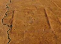
The finds of a pottery and brick-burning workshop are vivid proof of this. The central part of Ornek is a quadrangular, almost square, platform, with its tops oriented to the cardinal points. Its dimensions along the crest of the surviving surrounding rampart are 155 x 160 meters.
The embankment with a height of up to five meters has a base width of 11 - 15 meters. Entrances in the form of breaks in the shaft are guessed on each of the four sides. All of them were connected by roads intersecting in the center.
In the corners and along the perimeter of the wall, in the places where the towers were once located, small hills can be traced. On the northeastern wall, along with the corner ones, there were 7, on the northwest - 6, and on the southeast and southwest - 9 each.
Inside the walls, on the surface of the settlement, small heights in the form of oval hillocks are visible, located in the southern corner and near the northwestern wall. A flat rectangular hill adjoins the northeastern wall.
In the center of the settlement there are round pits of three reservoirs connected to each other. The diameter of one of them is 15 meters, the other two are 30 meters. The central ruins are adjoined by an area surrounded by a rampart with 31 towers along the perimeter.
The height of the shaft above the surface is 1 - 2 meters, of the towers - 1.5 - 2.5 meters, the width at the base is 3 - 5 meters. In addition, in the eastern corner of the building there is an extension in the form of a rectangular platform.
And from the outside along the gorge there are sections of rectangular, square and irregular shapes, fenced off from each other by stone boulders. The author of the scientific publication “Sedentary culture of the northern slopes of the Zailiyskiy Alatau in the VIII - XIII centuries” Tamara Savelyeva, comparing Ornek and Talgar, located in the foothills of the Zailiyskiy Alatau, which she had studied for a long time, found many similarities in their structure.
It turned out that they both had a quadrangular shape and were surrounded by a fortress wall. Residential and utility premises are also similar. The layout of the houses in the construction of which stone was used is very close.
A characteristic feature of the city manor is the presence of a complex of residential buildings with a large yard - a corral for livestock. Studying the materials of other medieval analogs, T. Savelyeva concluded that such cities were formed, as a rule, on caravan routes, eventually turning into centers of crafts and trade.
Some of them were fortified, others were open. They were mainly located near the headquarters of the rulers, in rich valleys and strategically convenient places. They arose where the seasonal semi-nomadic cattle breeding developed, which created the preconditions for agriculture.
Against this background, cities such as Ornek gradually formed, which are classified as "Tortkul". During its excavations, in addition to the remains of the premises of artisans and powerful fortifications, indicating that this place is the headquarters of a nomadic ruler, a mosque, a mausoleum, barracks-type outbuildings, as well as residential buildings and a Muslim necropolis were discovered.
In the book "Ancient cities of Kazakhstan" Karl Baypakov described various artifacts found in the talus of the settlement. In particular, archaeologists have collected rough stucco ceramics: fragments of hums, pots characteristic of the first half of the first millennium.
According to the author of the publication, the hill is apparently the remains of an early agricultural settlement - the forerunner of the city, which was formed here during the Middle Ages. Meanwhile, in another excavation, a rectangular structure measuring 40 x 20 meters was discovered.
The scientist believes that, most likely, these ruins belong to a Muslim mosque of the "pillar" type. The building, like the entire settlement, was oriented to the cardinal points. The clearing of the stone base made it possible to reveal the column base system.
Two of them are blocks hewn out of massive boulders. One, with a rounded lower part, is decorated with double-line cut ornaments. The design depicts a figure in the form of a vase leg, on which there is a leaf with two curls.
Images of anthropomorphic creatures are carved on two sides of the second trapezoidal block. The third base is a two stage block. The remaining 11 bases of the columns are stone blocks, flattened from above, with a total size of 0.8 x 0.8 meters.
They form regular rows with distances of 3 - 3.5 meters from each other. K. Baipakov suggested that there should have been 55 or 66 columns in total. One of them, found in the 1960s, is still kept in the regional museum of local history in Taraz.
The column is carved out of gray sandstone almost 2 meters high and about 30 centimeters in diameter. In its upper part there are four relief medallions with stylized images of a human face with round eyes. Below are two ornamental belts of semi-ovals and triangular figures.
According to the Zhambyl archaeologist Iskander Torbekov, this column could well be associated with the Tengrianism that was once widespread in these lands. - Ornek is one of the unique and interesting cities in the Chu-Talas valley from the point of view of history and archeology, which was part of the Talas oasis and stood on the Great Silk Road.
Being in a geographically, economically and strategically convenient location, being subordinate to Taraz, Ornek controlled two routes, tracking trade flows from Europe to Asia and back. Finds of specialists of the Institute of Archeology named after A. Margulan and the Institute of History and Ethnology named after A. Ch. Valikhanov testifies to the great importance of Ornek in that era, - said Iskander Torbekov.
According to him, despite the fact that the excavations were carried out 3 - 4 times, and not on a large scale, only for 2 - 3 months, they provided enough material to understand: Ornek was a fairly large and rich city for that time.
For example, during the excavations, a large number of various ceramic dishes were found, made by both local craftsmen and potters from China, Byzantium, Iran, Bukhara, Samarkand and Kokand. In addition, many coins of the periods of the Türkic, Turgesh and Karluk kaganates, as well as local minting of the Karakhanid era, were found here.
Of interest to archaeologists is the carving on adobe walls in the chambers of wealthy people. - The city ceased to exist in the XII century, even before the Mongol invasion, - says I. Torbekov. - The exact cause of his death has not been established.
Perhaps its destruction occurred as a result of an attack by nomads or during local wars. It is also possible that he was attacked by a single Mongol-Tatar detachment. In any case, the city was destroyed by storm, after which, unfortunately, it was never rebuilt.
Geographic coordinates of the medieval ancient settlement of Ornek: N42 ° 53'38.33 "E72 ° 08'51.10"
Authority and photos:
Mikhail TE, Zhambyl region. 13 August 2016 https://www.kazpravda.kz/articles/view/ornek-ot-rastsveta-do-zakata1