


![]()
You are here
Alamedin River.
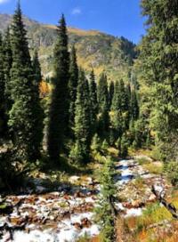
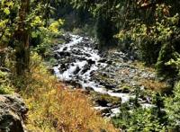
Sights of Alamedin river Kyrgyz ridge.
“In the sultry south, near the Tien-Shan,
Alamedin flows in the mountains of Kyrgyzstan.
Now it is noisy, then it becomes quiet again,
But it never gets tired of making noise."
Yuri Vizbor. “Alamedin. 1960.
Trip to Alamedin River from Bishkek.
The Alamedin River (Kyrgyz name Alamudun) is located between the Ala-Archa in the west and Issyk-Ata in the east, located on the northern slope of the Kyrgyz Ala-Too ridge in the Alamudun district of the Chui oblast.
The Alamedin River in its lower reaches two times flows into the At-Bashinsky Canal and partially gives its waters to the Chu River. The length of the river is 76 kilometers, the basin area is 317 square kilometers, the average water consumption is 6.36 cubic meters per second, the maximum is 300 cubic meters per second, and the minimum is 0.74 cubic meters per second.
The upper border of the river head is located at an altitude of 4347.9 meters above sea level, the lower border is at an altitude of 3368 meters above sea level. The river originates from the glaciers Alamedin Left (Tuyuktor West) and Alamedin Right (Tuyuktor East).
The main channel of the Alamedin River is formed at an altitude of 3361 meters above sea level from the tongue of the Western Tuyuktor glacier. In the upper part, the course of the river is stormy, runs through a narrow mountain gorge.
At the entrance to the Chuy valley, the channel widens and becomes shallower. The river basin contains 22 small lakes with a total area of 0.8 square kilometers and 53 glaciers with an area of 74.2 square kilometers.
High water on the river is observed in summer (May - September), low water - in winter. The waters of the river are widely used for irrigation of agricultural land.
Right tributaries of the Alamedin River.
Ashutor river in Kyrgyz ridge.
5.5 kilometers after the source of the Alamedin River, the 6.1 kilometers long Ashutor River flows into the right. The sources of the Ashutor river begin from the Progonny, Sovetkina glaciers and three more small glaciers located northwest of the Sovetkina glacier.
The sources of Ashutor lie at the northern end of the moraine at an altitude of 3299 meters above sea level. After 1.6 kilometers, the river bed is leveled and flows alternately into two small lakes located at an altitude of 3239 meters above sea level.
At 2.4 kilometers, the river on the left receives a small unnamed tributary.
The geographical coordinates of the Ashutor River: N42 ° 26'28.10 "E74 ° 42'17.71"
South Lake Alamedin.
After 2.6 kilometers, Ashutor flows into the South Lake Alamedin located at an altitude of 3151 meters above sea level. The length of the lake from the south-east to the north-west is 122 meters, the greatest width in the southern part is 41 meters.
The perimeter of the lake is 280 meters, the area reaches 3161 square meters. In the western part, on the shore of the lake, there is a huge stone.
Geographic coordinates of Lake South Alamedin: N42 ° 26'43.19 "E74 ° 42'06.77"
Lake Almedin North.
2.9 kilometers after the headwaters, Ashutor flows into Lake Almedin Severnoye, located at an altitude of 3131 meters above sea level. The length of the lake from south-east to north-west is 274 meters, width in the central part is 127 meters.
The perimeter of the lake is 628 meters, the area reaches 17967 square meters. Grass and alpine flowers grow on the eastern slope of the talus lake on the western shore of the lake.
Geographic coordinates of North Lake Alamedin: N42 ° 26'52.93 "E74 ° 41'54.12"
Lower Lake Alamedin.
4 kilometers after its source, the Ashutor river flows into the Lower Lake Alamedin, located at an altitude of 3067 meters above sea level. The lake has a rocker-like shape. Half of the way from Lake North Alamedin, the river flows in underground labyrinths and shortly before the Lower Lake appears on the surface.
The length of the Lower Lake is 226 meters, the width in the central part of the lake is 40 meters. The perimeter of the lake reaches 503 meters, the area is 6441 square meters. A hiking trail runs along the talus western part of the lake.
Geographic coordinates of the Lower Alamedin Lake: N42 ° 27'18.78 "E74 ° 41'34.15"
The mouth of the Ashutor River is located at an altitude of 2756 meters above sea level.
The geographical coordinates of the Ashutor River: N42 ° 26'28.10 "E74 ° 42'17.71"
Pastukhov Stream.
.9 kilometers after the confluence of the Ashutor River, on the right, the Pastukhov Stream 1.9 kilometers long flows into the Alamedin. The sources of the stream begin from the western part of the Pastukhov glacier at an altitude of 3667 meters above sea level. The mouth of the stream is 2647 meters above sea level.
Geographic coordinates of the Pastukhov stream: N42 ° 28'18.84 "E74 ° 41'00.17"
Salyk river.
16.7 kilometers after the headwaters of the Alamedin, the Salyk River, 3.2 kilometers long, flows into the right. The river's sources begin from the northern part of the Nicholas Roerich glacier at an altitude of 3524 meters above sea level. The mouth of the river is located at an altitude of 1993 meters above sea level.
Geographic coordinates of the Salyk River: N42 ° 33'31.73 "E74 ° 40'32.44"
Achiktash river.
18.8 kilometers after the source of the Alamedin River, the 3.8 kilometers long Achiktash River flows into the right. The sources of the river begin from springs on the western slope of the Alamedin gorge at an altitude of 3473 meters above sea level.
The main channel of the river is formed at an altitude of 3147 meters above sea level. In the upper reaches of the left tributary of the Achiktash River there is Mount Achiktash 4066.1 meters above sea level. There are no glaciers in the upper reaches of the river. The mouth of the river is located at an altitude of 1910 meters above sea level.
Geographic coordinates of the Achiktash River: N42 ° 34'13.52 "E74 ° 40'53.68"
Yantkunush river.
After 22.1 kilometers from the headwaters of the Alamedin River, in the vicinity of the Teplyn Klyuchi health center, on the right, the Yantkunush River flows into the river, 6.3 kilometers long. The river flows in a deep and winding gorge.
Yantkunush is formed into the main channel from two tributaries at an altitude of 2568 meters above sea level. The sources of the left tributary, 3.1 kilometers long, are located at an altitude of 3077 meters above sea level. The sources of the right tributary, 1.8 kilometers long, are located at an altitude of 3261 meters above sea level.
The mouth of the river is located at an altitude of 1,776 meters above sea level. There are no glaciers in the upper reaches of the river.
Geographic coordinates of the Yantkunush River: N42 ° 35'39.80 "E74 ° 41'00.27"
Burleigh-Bulak river.
Through 27.6 kilometers after the headwaters of the Alamedin River, the Berly-Bulak tributary with a length of 5.5 kilometers flows into the right. The Burley-Bulak river originates from the springs of the western slope of the Alamedin gorge.
In the upper reaches of the river there is the Kumbel pass with a height of 2885.5 meters above sea level. The Kumbel pass is a watershed of the Alamedin and Chelektor rivers. The mouth of the Burleigh-Bulak river is located at an altitude of 1537.5 meters above sea level.
Geographic coordinates of the Berlibulak river: N42 ° 37'39.78 "E74 ° 41'53.78"
The Alamedin River has 6 right tributaries from source to mouth.
Left tributaries of the Alamedin River:
Toktokul stream
The Alamedin River, 4.4 kilometers after the beginning of the source, receives the Toktogul tributary with a length of 2.8 kilometers on the left. The sources of the river begin from the northern part of the Toktogul glacier at an altitude of 3446 meters above sea level. The mouth of the Toktogul is located at an altitude of 2826 meters above sea level.
Geographic coordinates of the first, left tributary of the Toktogul: N42 ° 26'53.31 "E74 ° 39'43.84"
Utrenny Stream.
1 kilometer after the confluence of the Toktogul stream into the Alamedin, the Utrenny stream, 1.7 kilometers long, flows into the left. The stream originates at an altitude of 3313 meters above sea level from the eastern part of the Utrenny glacier. The mouth of the stream is located at an altitude of 2750 meters above sea level.
Geographic coordinates of the left tributary of the Morning: N42 ° 27'26.61 "E74 ° 39'47.57"
Altyntor river.
8.5 kilometers after the source, Alamedin receives another left tributary of the Altyntor, 5.5 kilometers long. The river is formed into one channel from two tributaries. The right tributary originates from an altitude of 3163 meters above sea level from the eastern tongues of the Tributary glacier.
The left tributary originates from the eastern tongue of the Kara-Too (Mayakovsky) glacier. On the right slope of the river, behind a huge rock mass, there is Altyntor Lake located at an altitude of 2761 meters above sea level.
3.6 kilometers after the headwaters, the Altyntor River in the vicinity of the Black Mountain goes into underground channels and only after 500 meters reappears on the surface. The mouth of the river is located at an altitude of 2341 meters above sea level.
Geographic coordinates of the Altyntor River: N42 ° 28'38.95 "E74 ° 37'17.13"
River Kuturgansu.
13.7 kilometers after the source, the Kuturgansu River flows into the Alamedin on the left, with a length of 4.7 kilometers and originating at an altitude of 3415 meters above sea level. The upper reaches of the river are of two tributaries and only at an altitude of 2911 meters above sea level, the river forms into one channel.
The right tributary originates from the tongue of the Zabirov glacier (Dzhandy-Su), the left one from the Vilesov glacier. The mouth of the river is located at an altitude of 2159 meters above sea level.
Geographic coordinates of the Kuturgansu River: N42 ° 31'48.44 "E74 ° 37'37.31"
River Atjailo.
3.4 kilometers after the confluence of the Kuturgansu River into the Alamedin, the Atjailo tributary 4 kilometers long flows into the left. The sources of the Atjayo are located at an altitude of 3395 meters above sea level on the eastern slope of the Alamedin gorge in the Kunakjailo tract. The Atjailo estuary is located at an altitude of 1989 meters above sea level.
Geographic coordinates of the Atjailo River: N42 ° 33'39.05 "E74 ° 39'00.38"
An unnamed left tributary of Alamedi River.
19.7 kilometers after the headwaters of the Alamedin, an unnamed 2.8 kilometers long tributary flows into the left, originating at an altitude of 2852 meters above sea level. The mouth of the tributary is located at an altitude of 1878 meters above sea level.
Geographic coordinates of the unnamed, left tributary: N42 ° 34'56.95 "E74 ° 39'05.55"
Kurukchichkar river.
In 21.6 kilometers after the headwaters of the Alamedin, the Kurukchichkar tributary with a length of 4.6 kilometers flows in on the left. The Kurukchichkar tributary originates at an altitude of 3140 meters above sea level.
Partially the waters of the stream are replenished from the Chichar spring located at an altitude of 2559 meters above sea level. In the northwestern part of the source of the river, there is the Chichar pass with a height of 2833.9 meters above sea level. The mouth of the river is located at an altitude of 1792 meters above sea level.
Geographic coordinates of the Kurukchichkar River: N42 ° 35'44.81 "E74 ° 39'05.72"
Chunkurchak river.
After 34.2 kilometers from the source, Alamedin takes on the left a tributary of the Chunkurchak, 18.2 kilometers long, which originates at an altitude of 3680 meters above sea level. The river's sources begin from the northern tongues of the Western Baichechek and Eastern Baichechek glaciers.
Also in the northern ridge, the upper western part of the Chunkurchak gorge, there are three small unnamed glaciers, from which the river receives left tributaries. The moraine of the glacier, which starts from the northern tongue of the Beychekey West glacier, is 3 kilometers long.
There are 5 small moraine lakes on the moraine. The main channel of the Chunkurchak River is formed at an altitude of 2,451 meters above sea level. At 5.7 kilometers after the source, a stream flows into Chunkurchak on the right. At 9.6 kilometers, the river enters a narrow and deep gorge of the same name, 3.7 kilometers long.
The river reaches the Tatyr village 14.5 kilometers after its source. The mouth of the river is located at an altitude of 1310 meters above sea level. The Chunkurchak River is the longest tributary of the Alamedin River.
Geographic coordinates of the Chunkurchak River: N42 ° 38'38.47 "E74 ° 36'58.83"
Alamedin River has 8 left tributaries from source to mouth.
In total, Alamedin River has 14 distinct river tributaries.
At 22.2 kilometers from the headwaters of the Alamedin River, on the right bank, there is a sanatorium with thermal radon waters "Teplyi Kluchi". At the exit from the Alamedin gorge to the Chuy valley (near the village of Kok-Dzhar), a hydroelectric complex was built.
At 46 km the river passes through a reservoir near the city, 50 km from the headwaters of the Alamedin River reaches the Oktyabrsky district of Bishkek. The river flows through the city from south to north. 2.7 kilometers before the mouth, the Alamedin River flows into the At-Bashi channel for the first time.
At 73 kilometers, the river flows into the At-Bashinsky channel. At 76 km in the western part of the village of Kordai, the Alamedin River loses its name. Its waters partially flow through the eastern channel into the Chu river and the At-Bashinsky channel.
The first village on the way of the river at the exit from the mountains is Kok-Tash, outside the city the river flows through the village of Leninskoye.
Geographic coordinates of the Alamedin River: N42 ° 35'42.88 "E74 ° 39'44.24"
Authority and photos by
Alexander Petrov.