


![]()
Вы здесь
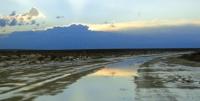
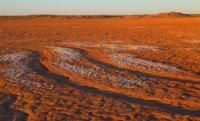
River course of Zhanadarya.

Cultural heritage of Kazakhstan.
“Only the heart is sharp-sighted. You cannot see the most important thing with your eyes ”.
A. Saint-Exupery.
Registers of monuments of history Kyzylorda region.
Zhanadarya is the southernmost of the ancient river channels of the Syrdarya. It was the main channel of the river in the first half of the Ist millennium BC. e. and by III - II centuries BC. e. Until 1819 it flowed into the Aral Sea.
It branches off from the modern channel in the Kyzylorda region, heading to the southwest, crosses the Kyzyl Kum in the territory of the modern Kyzylorda region, getting lost in the sands of modern Karakalpakstan near the former southeastern coast of the Aral Sea.
The total length is about 300 kilometers. In the second half of the XXth century, a part of the Zhanadarya channel was canalized (along with another channel, the Kuandarya), and the flow of a part of the Syr Darya waters from the rice paddy system was directed there.
Received the name Zhanadariinsky canal (Kaz. Zhanadaria canals) - an artificial watercourse located on the left bank of the Syrdarya river, which passes through the territory of the Kyzylorda region. The Zhanadari Canal was put into operation in 1958.
This canal has 19 hydraulic structures and existing branches with a total length of about 150 kilometers. The canal is designed to supply water for irrigation of pasture areas in the north of the sandy Kyzyl Kum desert and irrigate crops of fodder and vegetable and melon crops, as well as watering natural fodder lands.
The length of the Zhanadari Canal is 592 kilometers 300 meters, of which 535.6 kilometers passes along a natural channel. The capacity of the canal in the head section is 50 cubic meters per second, the natural channel is up to 200 cubic meters per second.
At the 210th kilometer of the Zhanadarya canal, the Kuandaria canal begins with a throughput of 20 cubic meters per second and a length of 436.4 kilometers using the Kuandarya dry channel (407 kilometers long) with a water flow rate of up to 60 cubic meters per second.
Several hunting farms are located along the channel of the Zhanadari Canal. In the lower reaches of the Zhanadarya, it is a system of oxbow lakes, a strip of black saxaul forest among the sands. Projects on the use of the channel for drainage of water during the spring floods of the Syr Darya are being considered.
The Zhanadarya Valley was the early medieval kingdom of Jend. Later, the Zhanadarya valley was a nomadic habitat for the Karakalpaks, who moved to the lower reaches of the Amu Darya after another degradation of the channel. In the basin of the channel there are numerous ruins of adobe structures of different eras, well preserved due to the dry climate and the absence of a modern permanent population (fortified settlements, settlements, fortifications, necropolises, cemeteries, mausoleums, saint tombs).
The largest ancient settlement is Chirik-Rabat (Shirikrabat), located on the territory of Kazakhstan in the Kyzylorda region in the Karmakshy region, 200 kilometers from Kyzylorda. Discovered and investigated by S.P.Tolstov in 1946 and 1948-1949.
It functioned from the first middle of the 1st millennium BC. e. It was used as a fortress until the beginning of the XIXth century.
Geographic coordinates of the Zhanadarya river course: N44 ° 24'20.11 "E63 ° 56'08.96"
Authority:
https://ru.wikipedia.org/wiki/%