


![]()
Вы здесь
Muksu river.
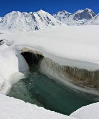
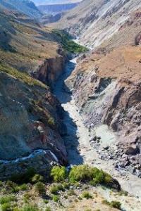
Photo tours in the Pamir mountains.
“I address you all tonight for who you truly are: wizards, mermaids, travelers, adventurers, and magicians. You are the true dreamers”
Brian Selznick.
Rivers of the Pamir mountains of Tajikistan.
The Muksu River flows in the north-west of the Pamir in the Jargital region of the Rasht region of Tajikistan, is the left source of the Vakhsh river (which forms, merging with the right component - the Kyzylsu river). The Muksu River is 88 kilometers long.
The basin area is 7070 square kilometers. It is formed by the confluence of the Seldara and Sauksoy rivers, which originate from the Fedchenko and Saukdara glaciers. Average water consumption is about 100 cubic meters per second.
The valley has steep, rocky slopes. The Muksu River flows from east to west south of the western part of the Trans-Alai Range. The river is formed at an altitude of 2745 meters above sea level near the village of Altynmazar at the confluence of the Seldar (left source of Muksu), Kaindy (central source) and Sauksay (right source).
At an altitude of 1834 meters above sea level, merging with the Kyzylsu River near the village of Dombrachi, it forms the Surkhob River. The southern side of the valley is formed by the northern spurs of the Academy of Sciences and Peter the Great ridges.
The river is fed by glaciers and snow, the flood on the river begins in late May and ends in early October. The average slope of the river is about 10 meters per kilometer. The Muksu basin contains the largest glacier in the Pamirs - the Fedchenko glacier.
The water in Muksu is dirty, the current is fast. Left tributaries of the Muksu River: Ayujidga River, flows from the Mushketov glacier, Fortambek, Khadyrsha, Sugran, Shagazy, Kyzylsu (flow from the Muzgazy glacier).
The right tributaries of the Muksu are the rivers Kyzylsu, Satsu, Surkhangou, Shirvoza, Khojatau. Muksu is one of the most difficult floating rivers in the territory of Tajikistan. On the upper part to the left tributary of the Ayujilga there are no obstacles to Muksu.
The river flows in a wide flat valley, fenced from the sides by huge ridge walls. The river here is often divided into channels. Behind the mouth of the Ayudzhilga tributary, the river enters the hard-to-reach Muksu-Dzhilga gorge.
The gorge abounds in the most difficult, completely different in character rapids, most of which are located in hard-to-reach rocky canyons. In August, at a flow rate of about 200 cubic meters per second, rafting on the river is most likely impossible, even on large ships.
The optimal rafting time is from September 20 to October 20.
Authority:
http://wiki.risk.ru https://ru.wikipedia.org