


![]()
Вы здесь
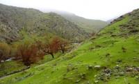
Kuraminsky ridge.
Central Asia Tour and Silk Road Tour.
“We leave something of ourselves behind when we leave a place, we stay there, even though we go away. And there are things in us that we can find again only by going back there”
Pascal Mercier. «Night Train to Lisbon».
The Great Silk Road in Middle Asia.
The Kuramin ridge is located in the mountains of the Western Tien Shan, located on the border of Tajikistan, Uzbekistan and Kyrgyzstan. In the northern part, the Kuramin ridge is bordered by the Chatkal ridge, along the southwestern and southern parts of the ridge there is a border from the north with Uzbekistan from the south with Tajikistan.
The northern slopes of the Kuraminsky ridge descend to the Akhangaran river. The Kuraminsky ridge borders the Ferghana Valley from the north-west. The length of the ridge is about 170 kilometers.
The highest altitude is 3,769 meters above sea level - Mount Boboyob.
In the north-west, the Chatkal ridge adjoins the Kuraminsky ridge, where Mount Kekbet is located between the Kuraminsky ridge located east of the Kurgal ridge, about 50 kilometers long, up to 3876 meters above sea level, is the Angren Plateau.
The slopes are poorly divided: the valleys of the south-eastern slope have elevations of about 1000 meters with a length of 25 - 40 kilometers, the valleys of the north-western slope are steeper. The rivers of the north-western slope flow into the Akhangaran river, the waters of the rivers of the south-eastern slope are disassembled for irrigation and do not reach the Syr Darya.
There is no icing on the Kuraminsky ridge, snowfields lie in the upper reaches of the gorges and at the highest peaks. The zone adjacent to the ridge of the Kuramin ridge is occupied by alpine meadows. The northern slopes are covered with deciduous forests, on the southeastern slopes there is steppe and meadow vegetation with juniper thickets.
More than 20 simple passes with a height of 2,000 to 3,172 meters above sea level are known - Kensaz Pass.
Geographic coordinates of the central part of the Kuraminsky ridge: N40 ° 52'49.92 "E70 ° 17'45.84"
Authority:
"Glaciers." L.D. Dolgushin, G.B. Osipova. Series "Nature of the world." Moscow, the publishing house "Thought". 1989.
Photos
Alexander Petrov.