


![]()
Вы здесь
History of Pamir Mountains.
Best destinations Pamir mountains.
“What are men to rocks and mountains?”
Jane Austen. «Pride and Prejudice».
Natural Wonders Adventure in Tajikistan.
Riders descend from the heavens through the golden ray breaking through the misty cold sky ... Genghis Khan's menacing voice spreads through the canyons and valleys in the night silence ... Rang-Kul cave burns with mysterious light, fire-breathing dragons toss and turn in the lakes...
How many legends does the Pamir remember ! Not all traditions are just a figment of the imagination of those who roam the herds along the cold plateaus or collect drop by drop water on fields cleared of stones. This mountain country has seen many, many events...
“I see how time slowly flows through the highest mountains, how it got lost in the plexus of deep rocky gorges,” wrote Pavel Luknitsky, a Soviet writer who studied the Pamirs not only from books. - A caravan stretches along a narrow path, over the plumb lines of gigantic cliffs.
Again and again it is necessary to untie the horses, put the packs on their backs, and tied up with woolen lasso, climb the cliffs hanging over the angry river, and then on the same lasso drag the horses scared, tall, trembling, scratched by sharp stones, through the dangerous place.
Tighten them again and again lead the extended caravan, crossing the descending into the abyss, unfaithful, quick-moving scree. Sometimes it seems to me that the three riders ahead of me are Maffeo, Nicolo and Marco Polo, that I myself, a Russian, have joined the caravan of Venetians somewhere here in the mountains and now I share with them all the charms and all the difficulties of the slow way.
It seems to me so because seven centuries in this country of the highest mountains have no meaning, time is measured by other standards and it is difficult to distinguish a year from a century on the Eternity scale, according to which these million-year-old mountains calculate their lives.”
Pamir - like a high mountain bridge, thrown between Asia, Afghanistan, China, India and Asia of Bukhara and Samarkand, from where the path went further, to the west; From time immemorial, he beckoned those who came with weapons or with goods.
Recently, the Soviet researcher A.N. Zelinsky, based on ancient and ancient Chinese sources, the results of archaeological work, as well as personal research, compiled a map of the ancient routes that passed through the Pamir and Pamirie during the heyday of international trade, in the Kushan era (I - IV centuries AD ).
Almost all the main routes ran in the latitudinal direction. This is primarily the path of Ptolemy through the Central Pamir and the Great Pamir Road through the Wahan Valley. Apparently, the Great Pamir Road was the main stretch of the Great Silk Road within the Pamirs and Pamir.
And another, also the main road, ran along the northern edge of the country of mountains; and there was still the only meridional route — through the eastern outskirts of the Pamirs. The main paths branched, and their shoots scattered along the valleys and mountain ranges.
Paths leading from the south of the Pamirs to northern India were intertwined into the knot, and it was very important, this knot, if we talk about ancient cultural contacts. Fortified fortresses stood along the Pamir paths.
Especially powerful fortresses were in the Wahan Valley, on the main channel of the Great Silk Road. The Kushan Empire (the Pamir was its eastern outskirts) erected them to guard the ancient ways and protect itself from the military threat of Han China.
For centuries, Buddhist pilgrims roamed the Pamirian ways - thanks to them, many Asian people were able to get acquainted with the Buddhist culture of India. At all times, there were trade caravans, and inquisitive merchants brought to foreign countries not only multicolored goods, but also stories about the country of giant mountains.
One of these stories of the Venetian Marco Polo, passing through the Pamirian high at the end of the 13th century, has come down to us. For a long time, his notes were almost the only document about the Pamirs.
In the Pamirs, at a four-kilometer height, under the very clouds, I was led by a study of the history of mining. A man came and comes to the mountains for minerals - mountains in this sense are immeasurably more generous than the lowlands...
In 1962, the Kuh-i-Lal Geological Party asked our institute to conduct archaeological research in the area of the village of Kuh-i-Lal, on the right bank of the Panj (Western Pamir). Once upon a time, lalas, famous Badakhshan lalas, and noble spinel were mined here.
Listen to what Marco Polo writes: “Balash gemstones, beautiful and expensive stones are found in that area; they will be born in mountain rocks. The people, I tell you, tear out large caves and go down deep as precisely as they do when they dig silver ore; they dig caves in Mount Shighinan (Shugnan. - M. B.) and extract balas there by royal order, for the king himself; under pain of death, no one dared to go to that mountain and get stones for themselves, and whoever takes the stones out of the kingdom will also pay for it with his head and good...”
The Kuh-i-Lal deposit (Lal mountain) turned out to be surprisingly interesting, if only because it has preserved over 450 ancient workings. But ... it’s not enough to know that they are abandoned and ancient. It is necessary to establish the stages of operation of the mine.
But it turned out to be difficult: the most reliable evidence of a past life - the miner’s settlements - has not been preserved. It was then that I first clearly understood that hard. Collapses and villages did their job. I had to examine the most affordable workings of Kuh-i-Lal and, as they say, “squeeze” everything that is possible from them.
It was especially interesting to examine the development, which was registered by geologists under No. 410. Fear and admiration possessed us when we examined this monument to human labor and patience. We crawled along the corridors, the cross section of which at best was a meter and a half.
Horizontal and vertical workings united 30 halls - the largest had an area of 12 by 22 meters with a height of 8 meters. The total depth of the vertical space was 40–50 meters. Up to 10 thousand cubic meters of rock was taken out of the mine!
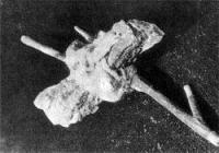
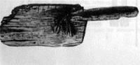
And this is only a part, though a large part, of the entire production: the ancient miners laid as much space as necessary. Of course, the scope of the work was colossal. Following the traces that remained on the walls of the workings, it was possible to restore what the miners of Kuh-i-Lala worked with. It was a Kylo, a wedge, a chisel and an awl-type instrument.
It is curious that the 15th-century traveler Ruy-Gonzales de Clavijo, describing the mining of Badakhshan lalas, also mentions a chisel: “Every day a piece of rock is broken off to look for them (spinel crystals. - M. B.), and if they find ore, they can separate they are very clean, they take the stone in which they are located, and gradually break off with a chisel around..."
But even these details could not help dating: the same tools accompanied miners for hundreds and even thousands of years. Only much later, turning over a hefty mountain of literature, collecting everything that is known about Badakhshan Lalas, it was possible to restore the picture of the life of the mine.
The mine reached its heyday in the IXth - XIIth centuries. The work in development 410 also dates back to this time. But the mine also lived in later times: in the XIIIth – XVth centuries and in the 17th – 19th centuries.
I don’t know how generally acceptable the phrase “catch a thread - stretch a ball” is acceptable to scientific research. But in this case, Kuh-i-Lal really turned out to be a "string", if we talk about the history of mining, about medieval history, the most poorly studied link in the entire history of the Pamirs: too little evidence of the XIXth - XIIth centuries has reached us.
In 1963, the Tokuz-Bulak Exploration Party sent a request to send an archaeologist. In the area of Tokuz-Bulak, the left tributary of the Gunt, they found old "silver" workings, and when installing the compressor, they came across an ancient burial site. And it is at an altitude of 4100 meters!
Tokuz-Bulak (Shugnansky district of the Western Pamirs) turned out to be a picturesque corner. Green thickets along the river, green lawns on the slope of the ridge. Geologists camped at the foot of the ridge. They showed me not far from the camp, on the shore of an unnamed brook, a site with old slags. Here we laid a small pit.
Heavy soil, powerful stone blockage - it was difficult to work. With one worker, whom geologists singled out for me, quite understandable curiosity, we dug a pit, examined the workings and burials. But alas ... the material was very poor.
Of course, before us were the remains of an ancient settlement of metallurgists, who worked with great skill on the local stone, making it “bricks” of triangular and rectangular shape for metallurgical furnaces. But the time when they worked and mined ore could not be established.
The Tokuz-Bulakskoye field has so far “hung” in the air. And how I wanted Tokuz-Bulak to reveal the secret of the silver Vakhan mines mentioned by al-Istahri, the author of the 10th century: “There are rich silver mines in Wahan”. In the XIXh - XIIth centuries, Central Asia was famous for its silver.
Written sources inform us of three mining areas. The location of the two is now established: the medieval Ilak corresponds to the present Karamazar; Shelji - Talas valley, only the location of the Vakhan mines is unknown...
Meanwhile, the tangle unwound further. In the winter of 1963, geologist Lyudmila Idrisova came to the institute. Finds lay on the table: the material was pronounced medieval, familiar to the archaeological eye. Among the finds were two coins.
They determined the time and place of their coinage. One is Ferghana, 987, the second is Kashgar, 1005. Lyudmila said that they discovered ancient workings and the remains of buildings. The developments interested me, as it became possible to count on accurately dating material.
But the buildings... After all, this means settlement. And where - in the Eastern Pamirs! All my archaeological experience has cast doubt on this. The fact is that the history of the ancient regions of the Western Pamirs - Vakhan and Shugnan, has more than one millennium: fortresses, the beginning of which dates back to the IIIrd century BC, have long been known.
The natural conditions of the Western Pamirs, albeit a mountainous territory, have never raised doubts among researchers that a person could live here. But the Eastern Pamirs? This is a cold, alpine desert with a harsh, sharply continental climate, closed on all sides by high mountain ranges ... It was natural to think that the Eastern Pamir was unsuitable for settled life.
This was confirmed by archaeologists that in the Eastern Pamirs there may be traces of primitive man. This prediction was brilliantly justified by the works of archaeologist B. A. Ranov. He established that the first people lived in the Pamirs about 10 thousand years ago (recently, Tajik archaeologists led by V. Ranov discovered near the village of Shugnou a site of primitive hunters who lived in the XII millennium BC. The life of a person in the mountains with each new discovery is all more moved back into the centuries. - Approx. ed.).
Here you have the natural conditions! But 10 thousand years is still an impressive period of time. Or maybe the climate of the Eastern Pamirs was warmer at that time? This is precisely what V. A. Ranov and L. F. Sidorov claim.
Not all researchers agree with them, but we will not go into the details of the discussion, since we are talking at best about the possibility of life, and it is settled, just a thousand years ago. According to experts, the modern climate in the Eastern Pamirs was established at the turn of our era.
Yes, it would hardly have occurred to archaeologists to specifically search for the remains of settled settlements, and even from the 9th-12th centuries. Therefore, it is appropriate to express gratitude to the geologists of the Pamir exploration expedition: all the monuments of the ancient mining in the Pamirs were discovered by them.
We owe them the first pages of the medieval history of the Pamirs... Still, after the People’s story, doubts remained and haunted. In the summer of 1964, a small detachment of archaeologists went to the valley of the Bazar-Dary River, the left tributary of the Murghab, to the mines and settlement discovered by geologists.
Before proceeding to the discoveries in the Bazar-Dary valley, I want to thank those who have been my constant helpers for three years. Now I can talk about the ancient miners of the Eastern Pamirs, the history of high mountain silver mines ...
While we were traveling by car to the Alichur Valley, from where we could get into the valley of the Bazar-Dary River, everything was easy, simple and pleasant. But the pack path through the Ak-Dzhilga pass in the North Alichur ridge to the place is assigned - only 20 kilometers on foot! - demanded great endurance, endurance and patience.
utting a path in the snow at an altitude of 4890 meters to conduct donkeys and horses with packs is a difficult test. Finally, we enter the street of the first medieval city, lost among the snowy mountains on the Roof of the world.
It seemed that the forgotten city appreciated our work - its generosity knew no bounds. The first pits, excavations of the first premises were surprising and alarming. Scraps of cloth from clothes, dried peel from a slice of melon, the first scrap of paper with scraps of words, and everything perfectly preserved...
There was no reason to lose my head. Doubts tormented hourly: "It can’t be, something is wrong here." And the next morning we found grape seeds, or pieces of fur, or documents again. Many days passed, more than one room was excavated, the most thorough reconnaissance of the area was carried out, geologists were interrogated with bias.
By the way, they were rather skeptical about our excavations at first. Geologists could understand: not every day you take out a wooden shovel from an ancient mine, or a piece of good burlap, or an iron wedge with the stamp of a master.
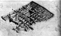
Do not tell the ups and downs of three field seasons. Each of them carried its joys and sorrows. But the city never let us down. Is it possible to call it a city? To this day, there is debate whether this is a city or just a settlement.
The city (I am a supporter of this point of view) is located on a narrow rocky terrace, the area of which was used to the maximum. Its central part, surrounded by a stone wall (all buildings in the city are made of stone), covers an area of about 360 square meters.
The territory of Rabad - the district of the city where artisans lived - is equal to 30 thousand square meters and is separated from the central part by an open area. Outside the city, a cemetery extends; we counted about 500 burials visible to the eye.
As shown by excavation materials, the city arose in the X century, and ceased to exist in the XII. For archaeologists who have been digging and exploring the ancient cities of Central Asia for decades, certain criteria have been established for the city.
It is usual if its area covers several tens of hectares, if it is located in the valleys or on the plains convenient for living, the development of trade, crafts, and agriculture. But the Bazar-Darinsky monument does not fit into this framework.
By area, it can be attributed to the category of small towns. But where was there to get more space - in a narrow mountain valley at an altitude of 3800 meters? Its existence is more than short - some 200 - 250 years. And living conditions with a stretch can be called tolerable...
Perhaps its occurrence can be associated with the silver crisis of the XIth - XIIth centuries in Central Asia? Depletion of the Ilak mines, the desire of each ruler to increase silver production by any means, military campaigns undertaken to annex the Shelji region rich in silver...
Perhaps the Pamir did not stand aside. But most likely it only stimulated the active exploitation of silver mines. Because to establish "suddenly" work ru Only eight years have passed since the first excavations at the Bazar-Dara.
And the boundaries of mining in the Eastern Pamirs went beyond the Bazaar-Darin valley. Geologists - again geologists! - opened a new area. It turned out to be the right tributary of the Murghab River - West Pshart with its tributaries. In 1970, the Pamir archaeological detachment excavated there and discovered three small settlements of miners, lying directly in the areas of silver mining.
The highest mountain of the mines examined by us is located in the headwaters of Sasyk at an altitude of 4900 - 5000 meters above sea level. These settlements and mines existed at the same time as the “silver” city in the Bazar-Dary valley.
Our current knowledge of the history of the Pamirs presents a chain with many missing links. I am sure that gradually they will become less and less. In 1971, we returned to Tokuz-Bulak for the second time, the one that "hung in the air", and carried out, as far as possible with a stone blockage, a thorough examination.
Now Tokuz-Bulak had something to compare, its dating became clear: in time it unites with the East Pamir group. The works of 1971 begin to lead us away, if not towards Vakhan, then, in any case, to Shugnan. Perhaps, in the end, materials will be found that will help solve the riddle of the Vakhan silver mines.
Authority:
Dushanbe city. M. Bubnova, an employee of the A. Donish Institute of History, Academy of Sciences of the Tajikistan.