


![]()
Вы здесь
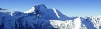
Peak of Ismail Somoni.
Pamir mountains Expedition Climbing.
"The guests of the cowardly cross out,
You only do well ...
You are the highest peak of ice
Irresistibly blissful”
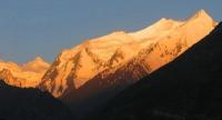
The seven thousandths of Pamir.
Communism peak, 7495 m. a. s. l. The location of the peak was finally determined in 1928. Variants of names until 1932 - Mount Go, Peak Garmo, Mount Gordon. In 1932, on the initiative of Tajik integrated expedition workers, the name of I.V. Stalin - “Our expedition, after a long study of it (the top - the bus) from the east, was named after Comrade Stalin.
It is the highest in the USSR "(NP Gorbunov. Tajik complex expedition. Introductory essay. Collection" Tajik complex expedition 1932. Edition of 1933. Leningrad branch). The peak of Communism was awarded in 1959. The first ascent was made by E.M. Abalakov September 3, 1933 along the eastern ridge from the Stalin Glacier.
A section of the route from an altitude of 7300 meters above sea level to the peak passes along the border of the described area (route 1). In 1957, through the Kuybyshev peak, the Pamir firn plateau and the western shoulder of the peak of Communism, the summit was reached by a team of climbers of the Burevestnik sports community led by K.K. Kuzmina.
The peak was first discovered during the Soviet-German expedition in 1928, but was mistaken for Garmo Peak. The error was fixed in 1932 when it turned out that Garmo Peak is 20 kilometers away. It was called the peak of Stalin, in 1962 it was renamed the peak of Communism.
In 1998, the summit was named after the founder of the first Tajik state, Ismail Somoni. The peak is an impressive rocky-ice pyramid with a square base, with four distinct sides. The first ascent on the eastern side was made by Evgeny Abalakov in 1933 as part of the Tajik-Pamir expedition of the USSR Academy of Sciences.
During the ascent, two members of the expedition died. A classic route along the edge of the Petrel is laid along the western wall. The third, southwestern wall of Ismail Samani Peak, located above the Belyaev Glacier and breaking off for more than 2000 meters, is very steep and dangerous; its characteristic element is the so-called "belly" - the top rocky bastion with a height of 600 to 800 meters, with a steepness exceeding 80 degrees.
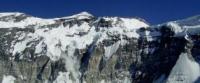
Here are the most difficult, of more than 30 climbing routes, which until today have been laid at the peak of Ismail Somoni. The wall was first crossed in 1968 by Eduard Myslovsky. An attempt to go through the "belly" team of Anatoly Kustovsky in 1973 turned out to be tragic.
Until now, Kustovsky’s body is on the wall. Subsequently, by the efforts of Anatoly Nepomnyashchy (1977), Kazbek Valiev (1980), Viktor Solonnikov (1981), the problem of the summit bastion was solved. A distinctive feature of these walls is the uniqueness of their technical parameters (a combination of a large vertical drop - up to 2.5 kilometers, with a large absolute peak height - 7495 m. a. s. l. and a large steepness of routes - more than 50 degrees.
A classic route passes through the northern slopes, which crosses the Pamir Plateau. This is one of the highest and longest plateaus in the world; its width is 3 km and its length is 12 kilometers from west to east. The lowest point is located at an altitude of 4700 m. a. s. l., the highest - at an altitude of 6300 m. a. s. l.
At an altitude of 6000 m. a. s. l., there is a small rocky peak, called the peak of Parachutists. This name was given to this peak in memory of the tragic expedition of Soviet military paratroopers organized in 1967 (the expedition pursued sports and training goals).
Many of the paratroopers crashed when the wind threw them onto the rocks, while others escaped by opening parachutes after exiting the wind stream. In 1928, this peak from a distance was considered the peak of Garmo. In 1932, it was discovered that then two different peaks were mistakenly taken by two groups of the expedition for Garmo peak, that the genuine Garmo peak (called Darvaz peak before) has a height of only 6 615 m. a. s. l.
And no one was able to come close to this top of the Pamir mountains. Its height was determined at 7,495 m. a. s. l. This highest peak in the Soviet Union was given the name - Stalin's peak. On the peak of Ismail Samani laid more than twenty routes of various categories of complexity.
The classic ascent route starts from Moskvin glade and runs along Borodkin's ridge. There are examples of extreme ascents to the peak of Communism in less than one day. Downhill skiing is popular. The base camp for climbing is located on a glade of Moskvina, near a high-mountain lake at an altitude of 4200 m. a. s. l.
Authority:
Books "Fan Mountains". Authors A.S. Mukhin, V.F. Gusev: "Nature of Tajikistan" Publishing House "Thought", 1982: Pavel Luknitsky. Travels in the Pamirs “Young Guard”, 1955: “Pamir”, publishing house “Planet” 1987, edited by corresponding member of the USSR Academy of Sciences M.S. Asimova.