


![]()
Вы здесь
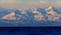
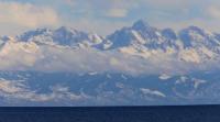
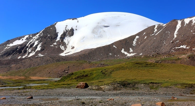
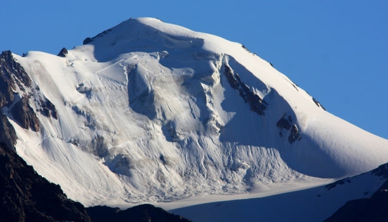
Glaciers in Terskey-Ala-Too ridge.
Tours in Terskey Alaa-Too mountains.
“Life while traveling is a dream in its purest form”
Agatha Christie.
Nature of Terskey-Ala-Too mountains.
A powerful ridge bordering the Issyk-Kul basin from the south. Its length is 380 kilometers, an average height of 4000 - 4200 meters above sea level, maximum 5216 meters above sea level. The northern slope of the ridge is long and dissected by deep gorges of numerous rivers. Southern, shorter, gently descends to the syrts.
On the Terskey-Ala-Too ridge within the Inner Tien Shan, 1375 glaciers with a total area of 1123.7 square kilometers, of which 757 glaciers with an area of 544.2 square kilometers, are located on the northern slope.
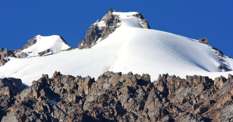
Small glaciers prevail here: 39% have areas of less than 1 square km, the same - from 0.1 to 0.5 square kilometers and only 14 glaciers are larger than 5 square kilometers. The largest valleys and complex valleys of the northern slope of the ridge Terskey-Ala-Too, located in the upper reaches of large rivers, have well-developed glacier feeding areas in complex multi-chamber circuses, separated by icefalls.
Avalanches and snowstorms play a great role in the nutrition of glaciers. Large valley glaciers descend to 3250 meters above sea level.
Sections of dead ice are sometimes located below their ends. The tongues of the glaciers are heavily covered with moraines. The total area of valley glaciers is twice the total area of glaciers of all other types. Numerous hanging glaciers (63% of the total) are located in the marginal parts of the northern slope of the ridge and on transverse spurs.
Their ends go down to 3650 - 3900 meters above sea level. There are several hollow, plume glaciers and flat top glaciers. The height of the snowline decreases from west to east from 3950 - 4000 to 3600 - 3700 meters above sea level, which is associated with the moisturizing effect of Issyk-Kul.
Glaciers in the extreme western part of the northern slope of the Terskey-Ala-Too ridge give runoff to the Chu (Shu) river basin. The slopes of the ridge here are steep and strongly dissected, with alpine landforms, but the height of the ridge is small.
Small glaciers prevail. In total there are 62 glaciers with an area of 29.7 square kilometers. The vast majority of glaciers on the northern slope of the Terskey-Ala-Too ridge belong to the basin of Lake Issyk-Kul (656 glaciers with an area of 510 square kilometers).
The largest glacier of the northern slope - the complex valley glacier Konorulen (5.8 kilometers long, 11.1 kilometers square) - is located in the Akterek river basin. A glacier formed from the confluence of two streams with vast areas
food and icefalls, has a complex hilly relief. The thickness of the ice at the end is 25-30 meters. Since 1947, in the Chon-Kyzyl-Suu river basin, the Tien Shan Physical-Geographic Station has been conducting systematic observations on the glaciers Karabatkak, Ashutor, Keldek, and Ailama.
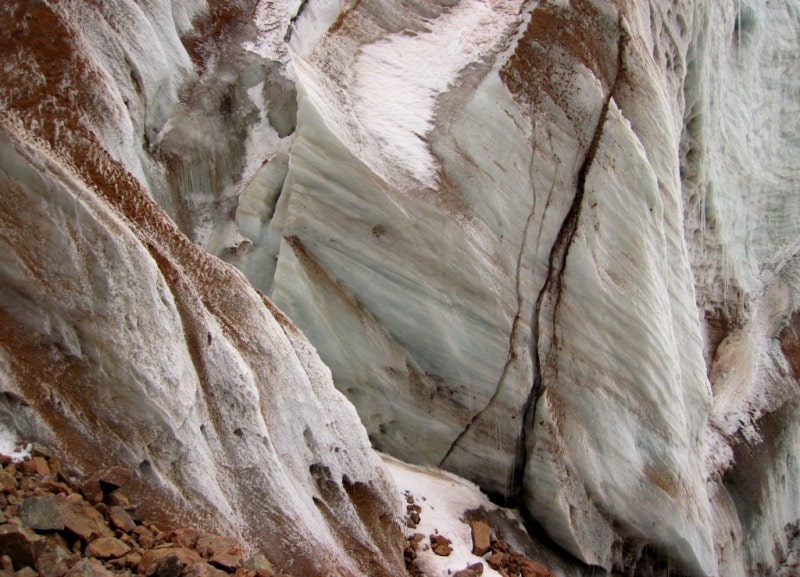
The Karabatkak glacier, with a length of 3.5 kilometers and an area of 4.5 square kilometers, originates in three chamber parts of the glacier with a flat and wide bottom. The glacier feeding area is separated by an icefall about 100 meters high.
Below the icefall, the surface of the glacier levels out. Power of ice is 50 - 80 meters. The end and left edge of the glacier are covered with moraine. Between the terminal moraine there is a lake, the drain from it is filtered through the moraine.
This glacier is the main object of stationary research. From 1960 to 1979, the average annual accumulation on it was 117 grams per centimeter square, ablation - 215 grams per centimeter square, mass balance -30.2 grams per centimeter square.
Of the 20 years of observation, only 5 years were with zero and a small positive mass balance, the rest with a negative one (Fluctuations, 1985). On the glaciers of the Chon-Kyzyl-Suu river basin and on several other glaciers of the northern slope of the Terskey-Ala-Too ridge, the speed of ice movement was measured.
On the Karabatkak glacier, they amounted to 11.5 meters per year, on the Ashutor glacier - from 3.4 to 9.8 meters per year, on the Aylam glacier - 15 meters per year. Hanging glaciers predominate east of the Ak-Suu River.
Only in the Turgen-Aksu river basin is there a large complex valley glacier Turgen-Aksu (7.5 kilometers long, 7.4 kilometers square). Its maximum thickness is 80 - 120 meters. Glaciers of the lower eastern part of the northern slope of the Terskey-Ala-Too ridge belong to the basin of Lake Balkhash.
Within the Inner Tien-Shan, these are glaciers in the basins of the Karakara and Tekes rivers (39 glaciers with a total area of 4.4 square kilometers). The glaciers of the northern slope of the Terskey-Ala-Too ridge are degrading, as evidenced by the recent separation of tributaries, large areas of dead ice and traces of the higher position of the surface of glaciers in the past.
Between 1943 and 1955, the end of the Koltor Zapadniy glacier retreated by 250 - 270 meters, the Koltor Vostochny glacier during the same period fell by 200 meters, and by 1962, by another 60 meters. The surface of its glacier over 7 years (1955 - 1962) decreased by 11 - 14.5 meters.
From 1943 to 1956, the Turgen-Aksu glacier retreated more than 400 meters. Most small glaciers maintain a stationary or close position to it. On the southern slope of the Terskey-Ala-Too ridge there are 618 glaciers with an area of 579.5 square kilometers.
Of these, 65 glaciers with an area of 27.3 kilometers square in the Chu river basin, 333 glaciers with an area of 257.3 kilometers square in the Naryn river basin and 220 glaciers with an area of 294.9 kilometers square in the Sary-Jaz river basin.
The nature of the relief and the depth of the dismemberment of the southern slope vary greatly throughout the ridge. Its western part to the Ton Pass is distinguished by a deep and complex dissection, especially in the Konorulensky mountain junction.
Alpine landforms with traces of ancient glaciation are developed here. Small glaciers, mostly hanging, are located mainly on the slopes of the northern expositions. There is not a single glacier larger than 3 square kilometers.
An important role in the nutrition of glaciers is played by avalanches and snow. To the east of the Ton Pass, the size of the glaciers increases, and in the upper reaches of the Karagoman River (Naryn River Basin) 4 glaciers are larger than 5 square kilometers.
Valley and hollow glaciers account for 30% of the total number of glaciers and occupy 80% total area. In the central part from the Barskaun pass in the west to the headwaters of the Irtash River in the east, the ridge ridge is an ancient alignment surface, gently sloping southward to the vast expanses of syrts and cut by wide transverse valleys with large valley glaciers in the headwaters.
A characteristic feature of the glaciation of this part of the southern slope of the ridge is the wide distribution of glaciers of flat peaks, which occupy almost all the watershed spaces. They make up about a quarter of all the glaciers in this area, both in number and in area.
Grigoryev Glacier. On the Grigoryev Glacier, the speed of ice movement varies from 1 - 2 m / year in the central part to 5 – 9 meters per year in glacier flows (Vinogradov. 1962). The largest flat-top glacier, not only on the Terskey-Ala-Too ridge, but also on the entire Tien-Shan, is the Grigoryev Glacier (4.0 km long, 8.3 km square).
It is located on the watershed between the valleys of the Kotuntor and Chontor Rivers (Arabelsu River Basin). Glaciers of flat peaks are characterized by a slightly inclined surface, insignificant thickness and low speeds. Most of them have several flow channels, sometimes to different rivers.
The complex valley glacier Kolpakovsky (10.0 kilometers long with an area of 30.4 kilometers square) is the largest glacier of the Terskey-Ala-Too ridge. The surface of the glacier in several places consists of icefalls.
The thickness of the ice near the end of the Kolo glacier is 50 meters. From 1869 to 1957, the glacier retreated 1.1 - 1.3 kilometers. To the east of the Kolpakovsky glacier, the division of the ridge is gradually increasing.
The Kyoluuu-Too ridge and other spurs separating the valleys of the left tributaries of the rivers leave south from it Irtash and Köoluu (Kuyli). In the upper reaches of these valleys are large valley glaciers with an area of 10 - 17 square kilometers with well-developed feeding areas,
located in complex multi-chamber glacial circuses, with lateral and middle moraines. Glaciers are smaller on slopes and in valleys of transverse spurs; hanging glaciers are widespread here, often with asymmetric feeding from the slopes of the north-western exposure.
Many glaciers are retreating. So, in the upper reaches of the Kuilu Zapadnaya River there are currently 4 independent glaciers, and as far back as 1943 they joined together. The Karakol-Tor glacier in the upper reaches of the river of the same name from 1943 to 1959 became shorter by 1600 - 1700 meters.
In total, there are more than 1150 glaciers in the Terskey Ala-Too ridge with a total area of over 1150 square kilometers.
The most significant glaciers in the Terskey-Ala-Too ridge.
Semenov Glacier, with a length of 9.2 kilometers, an area of 28.1 square kilometers, located at an altitude of 3510 to 5816 meters above sea level, belongs to the Bayankol river basin.
Glacier №. 61, with a length of 6.1 kilometers, an area of 7.1 square kilometers, located at an altitude of 3530 to 4040 meters above sea level, belongs to the Bayankol river basin.
The Karasaysky-1 Glacier, with a length of 4.8 kilometers, an area of 9.7 square kilometers, is located at an altitude of 3510 to 4520 meters above sea level, belongs to the Bayankol river basin.
The Keidel Glacier, with a length of 4.6 kilometers, an area of 3.6 square kilometers, located at an altitude of 3600 to 4340 meters above sea level, belongs to the basin of the Sary-Jazz River.
The Ashuu-Ter Glacier, with a length of 4.4 kilometers, an area of 5.2 square kilometers, is located at an altitude of 3540 to 4520 meters above sea level, belongs to the Bayankol river basin.
The Baigazy Glacier, with a length of 4.3 kilometers, an area of 4.4 square kilometers, located at an altitude of 3660 to 4380 meters above sea level, belongs to the Sary-Jazz River Basin.
Glaciers of the central part of Terskey Ala-Too.
The Kolpakovsky Glacier, with a length of 10.0 kilometers, an area of 19.7 square kilometers, located at an altitude of 3660 to 4750 meters above sea level, belongs to the Irtash River Basin.
The Karakoltor Glacier, with a length of 8.0 kilometers, an area of 13.1 square kilometers, located at an altitude of 3,780 to 5,040 meters above sea level, belongs to the Irtash River Basin.
The 7.5 km long Baroque East Glacier, an area of 11.1 square kilometers, is located at an altitude of 3840 to 5040 meters above sea level, belongs to the Irtash River Basin.
The Turgen-Aksu Glacier, with a length of 7.5 kilometers, an area of 5.1 square kilometers, located at an altitude of 3600 to 4630 meters above sea level, belongs to the basin of Lake Issyk-Kul.
The 6.7-kilometer West Bordu Glacier, an area of 18.8 square kilometers, is located at an altitude of 3,700 to 6,216 meters above sea level, belongs to the Irtash River Basin.
Glacier № 60, with a length of 6.6 kilometers, an area of 4.3 square kilometers, located at an altitude of 3820 to 4400 meters above sea level, belongs to the Keoluu river basin.
The Uyuntor Vostochny Glacier, with a length of 6.3 kilometers, an area of 8.7 square kilometers, is located at an altitude of 3400 to 4850 meters above sea level, belongs to the basin of Lake Issyk-Kul.
The Kotor South glacier, with a length of 6.1 kilometers, an area of 12.7 square kilometers, is located at an altitude of 3980 to 4720 meters above sea level, belongs to the Irtash river basin.
The 6.0 km long Baroque West Glacier, an area of 10.4 square kilometers, is located at an altitude of 4090 to 4600 meters above sea level, belongs to the Irtash River Basin.
Glacier No. 61, with a length of 5.8 kilometers, an area of 10.0 square kilometers, located at an altitude of 3800 to 4700 meters above sea level, belongs to the Keoluu river basin.
The glacier of Soviet Russia, with a length of 5.9 kilometers, an area of 6.9 square kilometers, located at an altitude of 3600 to 4700 meters above sea level, belongs to the Keoluu river basin.
The Pavliniy Khvost, with a length of 5.8 kilometers, an area of 5.3 square kilometers, located at an altitude of 3900 to 4500 meters above sea level, belongs to the Keoluu River Basin.
Glacier Bordu Vostochny, with a length of 5.8 kilometers, an area of 4.6 square kilometers, located at an altitude of 3750 to 4860 meters above sea level, belongs to the Irtash river basin.
Glacier №. 324, with a length of 5.4 kilometers, an area of 5.1 square kilometers, located at an altitude of 3970 to 4600 meters above sea level, belongs to the Irtash River Basin.
The Molo Zapadny Glacier, with a length of 5.0 kilometers, an area of 6.8 square kilometers, is located at an altitude of 3880 to 4560 meters above sea level, belongs to the Keoluu River Basin.
The Ekichat glacier, with a length of 5.0 kilometers, an area of 5.0 square kilometers, is located at an altitude of 3980 to 4800 meters above sea level, belongs to the Keoluu river basin.
Uyuntor Zapadny Glacier, with a length of 4.9 kilometers, an area of 5.6 square kilometers, located at an altitude of 3430 to 5280 meters above sea level, belongs to the basin of Lake Issyk-Kul.
The 4.6-km-long Sarachat Glacier, an area of 7.2 square kilometers, is located at an altitude of 3,700 to 4,400 meters above sea level, belongs to the Keoluu River Basin.
The Koltor Zapadny Glacier, with a length of 4.6 kilometers, an area of 6.8 square kilometers, is located at an altitude of 3400 to 4750 meters above sea level, belongs to the basin of Lake Issyk-Kul.
The Keldyke glacier, with a length of 4.6 kilometers, an area of 5.8 square kilometers, located at an altitude of 3300 to 4350 meters above sea level, belongs to the basin of Lake Issyk-Kul.
The Jeti-Oguz glacier, with a length of 4.6 kilometers, an area of 4.1 square kilometers, located at an altitude of 3100 to 4430 meters above sea level, belongs to the basin of Lake Issyk-Kul.
Ailama Glacier, 4.2 km long, covering an area of 6.8 square kilometers, located at an altitude of 3150 to 4510 meters above sea level, belongs to the basin of Lake Issyk-Kul.
The Juuka Glacier, with a length of 4.2 kilometers, an area of 4.7 square kilometers, located at an altitude of 3600 to 4410 meters above sea level, belongs to the basin of Lake Issyk-Kul.
The Kotor Zapadny Glacier, with a length of 4.1 kilometers, an area of 2.7 square kilometers, is located at an altitude of 3400 to 4600 meters above sea level, belongs to the basin of Lake Issyk-Kul.
Glaciers of the Western part of the Terskey Ala-Too Range
The Jerooy Glacier, with a length of 7.3 kilometers, an area of 8.7 square kilometers, is located at an altitude of 3420 to 4640 meters above sea level, belongs to the basin of Lake Issyk-Kul.
The Chong-Karagoman Glacier, with a length of 6.8 kilometers, an area of 10.5 square kilometers, is located at an altitude of 3960 to 4630 meters above sea level, belongs to the Naryn river basin.
Glacier Popov, with a length of 6.3 kilometers, an area of 9.9 square kilometers, located at an altitude of 3830 to 4763 meters above sea level, belongs to the Naryn river basin.
The Sarytor Glacier, with a length of 5.6 kilometers, an area of 8.8 square kilometers, is located at an altitude of 3800 to 4480 meters above sea level, belongs to the Naryn river basin.
Glacier No. 42, with a length of 5.4 kilometers, an area of 4.6 square kilometers, located at an altitude of 3730 to 4300 meters above sea level, belongs to the basin of Lake Issyk-Kul.
The Bolshoi Chontor Glacier, with a length of 5.0 kilometers, an area of 8.1 square kilometers, is located at an altitude of 3870 to 4640 meters above sea level, belongs to the Naryn River Basin.
The Koksay Glacier, with a length of 4.9 kilometers, an area of 5.6 square kilometers, is located at an altitude of 3310 to 4760 meters above sea level, belongs to the basin of Lake Issyk-Kul.
Glacier No. 40, with a length of 4.6 kilometers, an area of 4.4 square kilometers, located at an altitude of 3520 to 4620 meters above sea level, belongs to the basin of Lake Issyk-Kul.
Glacier No. 61, with a length of 4.4 kilometers, an area of 3.3 square kilometers, located at an altitude of 3840 to 4710 meters above sea level, belongs to the Naryn river basin.
The Akterek Zapadny Glacier, with a length of 4.1 kilometers, an area of 3.0 square kilometers, is located at an altitude of 3540 to 4670 meters above sea level, belongs to the basin of Lake Issyk-Kul.
The 4.0 km long Grigoryev Glacier, an area of 8.3 square kilometers, is located at an altitude of 4160 to 4550 meters above sea level, belongs to the Naryn River Basin.
The Korumdu Glacier, with a length of 4.0 kilometers, an area of 6.9 square kilometers, is located at an altitude of 3520 to 4460 meters above sea level, belongs to the basin of Lake Issyk-Kul.
Glacier № 393, with a length of 4.0 kilometers, an area of 4.1 square kilometers, located at an altitude of 3920 to 4580 meters above sea level, belongs to the Naryn river basin.

Authority:
"Glaciers." L.D. Dolgushin, G.B. Osipova. Series "Nature of the world." Moscow, the publishing house "Thought". 1989..
Photos by
Alexander Petrov.