


![]()
Вы здесь
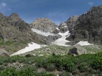
Glaciers of Yazgulemsky ridge.
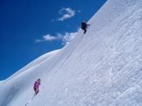
Side trip in Tajikistan.
"I remember that edge inspired,
There mountains are a cheerful crowd
Converged at the green river,
As if to a watering hole"
Yuri Vizbor. 1956.
Excursion trip Pamir mountains Tajikistan.
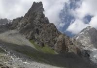
The southernmost of the latitudinal ranges of the North-Western Pamirs is the Yazgulemsky ridge located in the Murghab region of the Gorno-Badkhashan Autonomous Region. This ridge has a curving ridge line; its slopes are deeply dissected by river valleys.
According to the height and nature of glaciation, the Yazgulemsky ridge is divided into two parts. Western the part with a length of 128 kilometers stretches along the Yazgulem River, from the Panj River valley to the upper the course of the Rakzow River, and has an average elevation of 5370 meters above sea level, the highest point is the Woodor peak at a height of 6132 meters above sea level.
The eastern part, 42 kilometers long, borders the upper reaches of the Fedchenko and Grumm-Grzhimailo glaciers from the south. Its average height is 6155 meters above sea level, the highest point is the peak of the Revolution, 6945 meters above sea level.
The total area of glaciation of the ridge is 723.3 square kilometers, the number of glaciers is 496. The most large glaciers and the most powerful glaciation are located in the eastern part of the ridge. Here, from the base of the peak of the Revolution, the largest Pamir glaciers - Fedchenko and Grumm-Grzhimailo - start, the Yazgulem and Rakzou glaciers are located in the upper reaches of the Yazgulem river, and the complex valley glaciers Khabarvivharts, Yazgulemdara and Bashurvdara flow to the south.
The upper reaches of almost all of these glaciers are interconnected, forming continuous firn fields at the junction of the Academy of Sciences, Yazgulemsky ridge and its northern spurs. The glaciation area of the eastern part of the ridge is 497.3 square kilometers.
On the northern slope of 133 glaciers with an area of 343.1 square kilometers.
The Grumm-Grzhimailo Glacier (Muzkulak) is located in the Murghab region of the Gorno-Badkhashan Autonomous Region. The length of the glacier is 37.0 kilometers, an area of 142.9 kilometers square - the second largest glacier in the Pamirs, discovered in 1887 by an expedition of the Grumm-Grzhimailo brothers.
Its vast multi-chamber feeding area is located at the junction of the Yazgulem ridge with the Cold Wall ridge. The glacier flows north and takes on the left 8 large tributaries from the Kholodnaya Stena ridge and 3 smaller tributaries on the right, from the northern spur of the Yazgulem ridge.
Broad snout glacier well defined lateral and median moraine near the mouth of the valley is compressed by rocky sides and in the form of a tape 1.5 km wide moves into the Tanymas river valley. The surface of the glacier is difficult to pass because of the many cracks, bumps, peaked peaks, pyramids formed as a result of uneven melting.
Rakzow Glacier is located in the Murghab region of the Gorno-Badkhashan Autonomous Region. The length of the glacier is 17.4 kilometers, an area of 47.2 kilometers square, - a dendritic glacier, most of which, has a southerly direction, forms at the bottom of a wide trough at an altitude of 4,500 meters above sea level from several streams flowing from the slopes of different exposures.
The valley is poorly developed, and the part of the glacier located in it is narrowing up to 400 - 500 meters in narrow gorges, it expands to 1000 meters. At an altitude of 4,500 meters above sea level, shafts of lateral and middle moraines begin, which merge at the lower 3 kilometers of the glacier, forming a continuous moraine cover.
There are 113 glaciers with an area of 154.2 square kilometers on the southern slope of the eastern part of the ridge. About half of this area is accounted for by three complex valley glaciers: Khabarvivharts, Yazgulemdara and Bashurvdara.
The feeding areas of these glaciers lie on the slopes of the peak of the Revolution and through the passes are connected with the feeding areas of the glaciers of the northern slope, and the ends of the glaciers descend into the deep neighboring valleys.
These glaciers, as well as other valley glaciers of the southern slope, are characterized by highly moraine parts and patches of dead ice. In the western part of the ridge there are 250 glaciers with an area of 226.0 square kilometers.
Of these, 130 glaciers with an area of 130.4 kilometers square on the northern slope and 120 glaciers with an area of 95.6 kilometers square on the southern. Glaciers are scattered along the entire ridge and occupy the headwaters of deeply incised valleys - tributaries of the Yazgulem and Bartang rivers.
In the western part mostly small and hanging glaciers, to the east the number and area of glaciers increase, and in the area of Vudor peak, especially on the northern slope, there are complex valley glaciers formed from several caravans and valleys with poorly developed feeding areas and highly moraine parts.
Most glaciers of the Yazgulem ridge have signs of retreat - flat parts in coastal moraines, recently severed tributaries, patches of dead ice below the ends of the glaciers. The Yazgulemdara Glacier between 1946 and 1966 retreated to 2050 meters, and its area decreased by 0.7 square kilometers.
From 1928 to 1933, the Grumm-Grzhimailo glacier stepped on the right side by 375 meters, on the left - by 150 - 190 meters. By 1959, the end of the glacier receded 100 meters, but between 1962 and 1965 it again advanced 210 meters (Glacier Catalog. 1978).
The total area of glaciation of the Yazgulemsky ridge is about 4380 square kilometers.
The largest glaciers of the Yazgulemsky ridge.
The Grumm-Grzhimailo Glacier, with a length of 37.6 kilometers, an area of 143.0 square kilometers, is located at an altitude of 3610 to 6100 meters above sea level, belongs to the Tanymas river basin.
Raczow Glacier, with a length of 17.4 kilometers, an area of 47.2 square kilometers, located at an altitude of 3420 to 6250 meters above sea level, belongs to the Rakzow River Basin.
The Tanymas glacier-2, with a length of 15.6 kilometers, an area of 16.6 square kilometers, located at an altitude of 3900 to 6200 meters above sea level, belongs to a tributary of the Tanymas river basin.
The Vitkovsky Glacier, with a length of 15.0 kilometers, an area of 50.2 square kilometers, located at an altitude of 4900 to 5200 meters above sea level, belongs to the basin of the Fedchenko Glacier.
The Verkhny Muzkulak Glacier, with a length of 13.4 kilometers, an area of 24.5 square kilometers, located at an altitude of 4400 to 6300 meters above sea level, belongs to the basin of the Grumm-Grzhimailo glacier.
The Bushurvdara Glacier, with a length of 13.3 kilometers, an area of 21.7 square kilometers, located at an altitude of 3540 to 6000 meters above sea level, belongs to the basin of the tributary of the Khabarvivhats River.
The Tanymas-3 Glacier, with a length of 13.2 kilometers, an area of 12.8 square kilometers, located at an altitude of 4120 to 5900 meters above sea level, belongs to the Tanymas River Basin.
The Yazgulemdara Glacier, with a length of 12.9 kilometers, an area of 33.8 square kilometers, located at an altitude of 3920 to 6500 meters above sea level, belongs to the basin of the Yazgulemdara River.
Glaciers 133-134, with a length of 10.6 kilometers, an area of 15.3 square kilometers, located at an altitude of 3000 to 5640 meters above sea level, belongs to the basin of the tributary of the Roshtdara River.
The Small Muzkulak Glacier, with a length of 9.2 kilometers, an area of 8.3 square kilometers, located at an altitude of 4400 to 6200 meters above sea level, belongs to the basin of the Grumm-Grzhimailo glacier.
The Birjrafdara Glacier, with a length of 9.0 kilometers, an area of 11.3 square kilometers, located at an altitude of 3600 to 5530 meters above sea level, belongs to the Birjrafdara River Basin.
The Darabuguz Glacier, with a length of 8.8 kilometers, an area of 6.9 square kilometers, located at an altitude of 3100 to 5400 meters above sea level, belongs to the Daraibuguz river basin.
The Lyapnazar Glacier, with a length of 8.0 kilometers, an area of 9.5 square kilometers, located at an altitude of 3800 to 5800 meters above sea level, belongs to the basin of the Rakzow Glacier.
Glacier 112, with a length of 6.4 kilometers, an area of 3.9 square kilometers, located at an altitude of 4160 to 5500 meters above sea level, belongs to the basin of the tributary of the Yazgulemdara River.
The Kazakht Glacier, with a length of 6.3 kilometers, an area of 5.5 square kilometers, is located at an altitude of 3260 to 5000 meters above sea level, belongs to the basin of the Drankazdaht river.
Glacier Zakharchenko, with a length of 6.0 kilometers, an area of 5.7 square kilometers, located at an altitude of 4100 to 5200 meters above sea level, belongs to the tributary of the Mazardara River.
Glacier 155, with a length of 6.0 kilometers, an area of 2.9 square kilometers, located at an altitude of 3300 to 5000 meters above sea level, belongs to the basin of the Darankaddaht river.
Rakhzov Glacier, with a length of 5.8 kilometers, an area of 5.1 square kilometers, located at an altitude of 4080 to 5700 meters above sea level, belongs to the basin of the Rakhzovdar River.
Glacier 156, with a length of 5.7 kilometers, an area of 4.6 square kilometers, located at an altitude of 3760 to 6120 meters above sea level, belongs to the basin of the Bashuradara River.
The Nizhny Muzkulak Glacier, with a length of 5.7 kilometers, an area of 2.2 square kilometers, located at an altitude of 4320 to 5700 meters above sea level, belongs to the basin of the Grumm-Grzhimailo glacier.
The Kholodnaya Stena glacier, with a length of 5.6 kilometers, an area of 5.2 square kilometers, located at an altitude of 4120 to 5400 meters above sea level, belongs to the basin of the Havrazdara River.
Authority:
"Glaciers." L.D. Dolgushin, G.B. Osipova. Series "Nature of the world." Moscow, the publishing house "Thought". 1989.
Photos by
Alexander Petrov.