


![]()
Вы здесь
Tour to Semipalatinsk nuclear test site.


Excursion to Balapan test site.
"What a terrible thing we have created..."
Igor Kurchatov. Creator of Soviet atomic bomb.
Brief description of route from Semey to Degelen test site:
Semey - Kokentau village - Shagan river - Balapan test site - Telkem site - engineering structures (Balapan site) - Balapan village (B-2) - Degelen experimental site - Degelen village G point - Experimental field site (D ) - town of Kurchatov - town of Semey.
Distance of route: 369 km.
Season: from May, 10st till September, 30th.
Best time for travel: May, June - August.
Duration of tour: 2 days, 1 night.
Detailed program of tour to "Experimental Field" and to town of Kurchatov:
Trip to Degelen test site.
Day 1. Semey - Kurchatov (293 km).
Early departure from Semey.
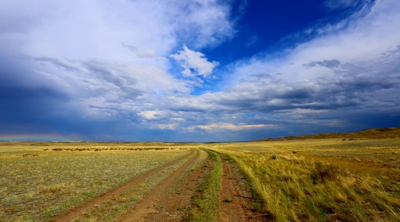
Transfer: Semey - Semeytau mountains - settlements Kyzyshek (Shcherbakovka) - Kokentau (Znamenka) - Shagan river - Balapan test site – test site Telkem (Atomic lake) (116 km).
After the town of Semey, our path goes southwest, after about 44 kilometers we pass not high mountains of Semeytau, which stretch in the meridional direction, for 49 kilometers. We pass the village of Kokentau, in the vicinity of the tract Ortashat, the road turns to the north-west, after 14 kilometers we pass the bridge over the Shagan River, we leave the grader and turn south to the Atomic Lake.
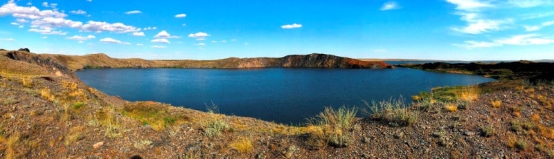
Here we are already on the territory of the Balapan test site. Arrival at the lake, which is located on the Telkem test site, on which only 2 underground explosions were carried out with the release of soil for the construction of reservoirs.
The Balapan test site is located in the southeast direction from the town of Kurchatov, on the left bank of the Shagan River.
The total landfill area was 100 square kilometers. It was used for underground testing of nuclear devices with a capacity of up to 120 kt in wells (vertical mine workings) and for individual tests with a capacity of up to 150 kt. A vertical well is a mine with a depth of 30 to 600 meters.
The test charge drops to the bottom of the well. At the Balapan site, 107 charge tests were performed. For 40 years, from 1949 to 1989, 473 nuclear explosions were carried out at the Semipalatinsk test site, including 90 air, 26 ground, 354 underground.
In addition to nuclear tests, 175 explosions using chemicals were carried out here, 44 of them with charges of more than ten tons. The Atomic lake is located on the Balapan test site; it was formed as a result of an experimental explosion to create a reservoir.
On January 15, 1965, at 05.59 hours GMT, at the confluence of the Shagan and Aschysu rivers, in well No. 1004, at a depth of 178 meters, the Chagan experimental industrial underground nuclear explosion was carried out. The capacity was 140 kt (equivalent to 2,000 coach wagon), as a result of which a funnel was formed with a depth of 100 meters, a diameter of 400 meters and a volume of 6 million cubic meters with a bulk of soil 20 - 30 meters high, which blocked the channel of the Shagan River.
In March and April 1965, a canal was created using chemical explosives, connecting the channel of the Shagan River with a funnel, where an atomic explosion was fired. As a result of the tests, two bodies of water formed - the inner one due to the filling of the explosion funnel (Atomic Lake) and the outer one (Shagan Lake) - the floodplains of the Shagan and Aschysu rivers.
Later, a stone and earthen dam with culverts was built here. During the atomic explosion, pieces of clay and soil spilled out of the crater, which rose to a height of up to 1 kilometer. At present (2016), the depth of the lake is 80 meters, the diameter is 444 meters, and the length of the coastline is 1480 meters.
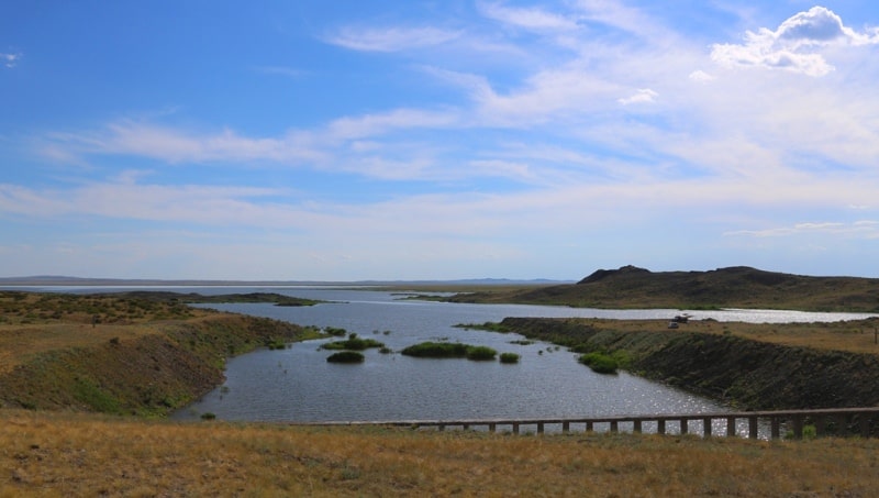
In the southern part, the Atomic Lake is connected by a 188-meter channel with Lake Shagan, into which on the south side flows the river Aschysu. The Shagan River flows north through the dam of Lake Shagan. In the future, it was planned in Kazakhstan with the help of nuclear explosions to create about 40 artificial reservoirs with a total volume of 120 - 140 million cubic meters.
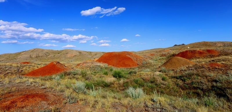
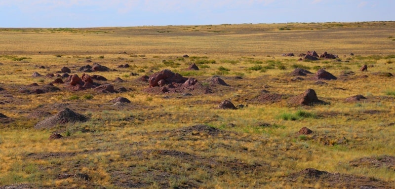
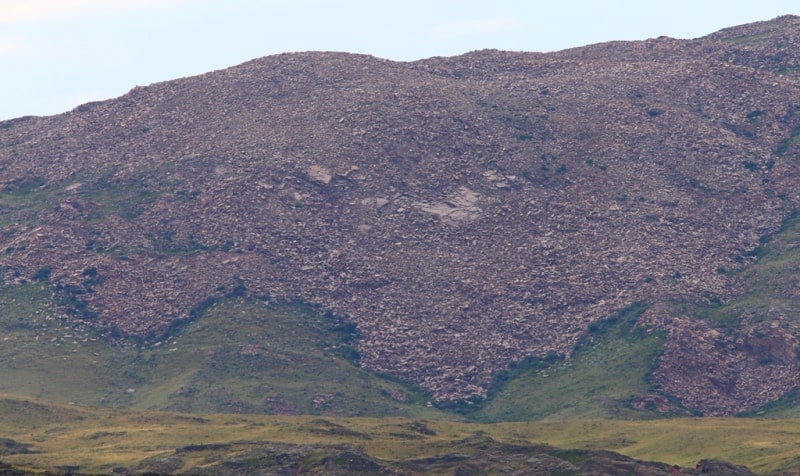
Around the lake there are huge hills, gigantic heaps of land, the results of the release of underground soil after the explosion. To the side of the lake there are separate pieces of huge stones - “bombs”, everything that was thrown from the depths of the earth by the energy of an explosion.
It resembles the effects of a volcanic eruption. After the explosion, these stone "bombs" were pristine and intact, and only eventually swam away, collapsed, and some left piles of colored earth. Using the example of these emissions, one can try to unravel the geological epochs of the structure of the earth.
On the opposite side of the lake, on the slope, emissions of colored rocks similar to clay are visible. An Atomic lake, almost perfect rounded, connected by a small strait to Lake Shagan. You might think that this is a volcano filled with water. Atomic explosions also give rise to volcanic lakes.
In the vicinity of the lake there are many different pipes sticking out of the ground. Nearby is a small grove of poplars. A road has been laid along the southern shore of the lake, which leads to a dam and a reservoir.
Visit to the lake, walk around the lake.
Transfer: Telkem site - engineering structures (Balapan site) (25 km).
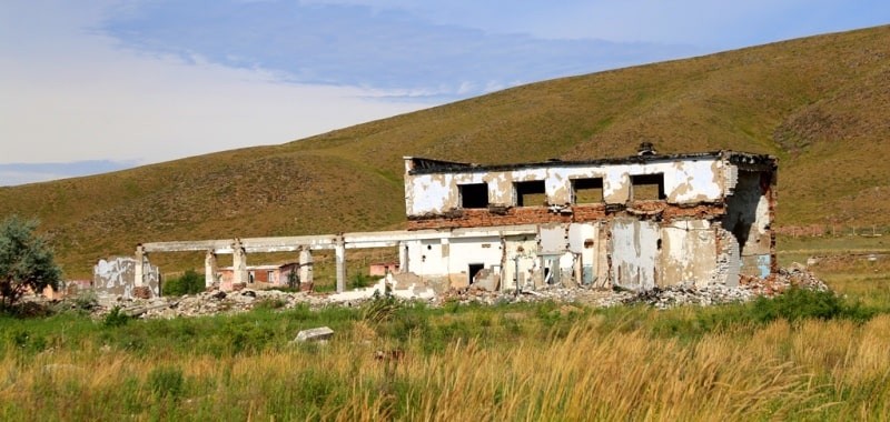
Along the way, we will visit one of the test sites, which is located 25 kilometers northwest of the Telkem site, there are 4 craters from the explosions filled with water. Here, engineering structures - shelters where military equipment was located, studied the effect of the explosion on equipment.
Here you can see the subsidence of the earth as a result of an underground nuclear explosion, this is the so-called “combat well”.
Transfer: Balapan site - Balapan village (B-2) (17 km).
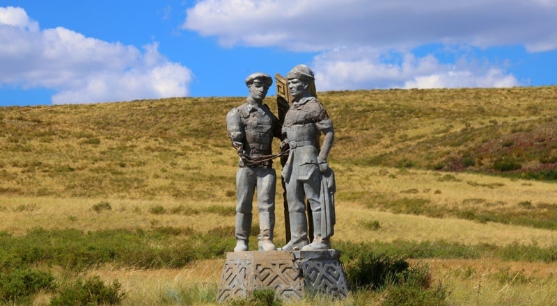
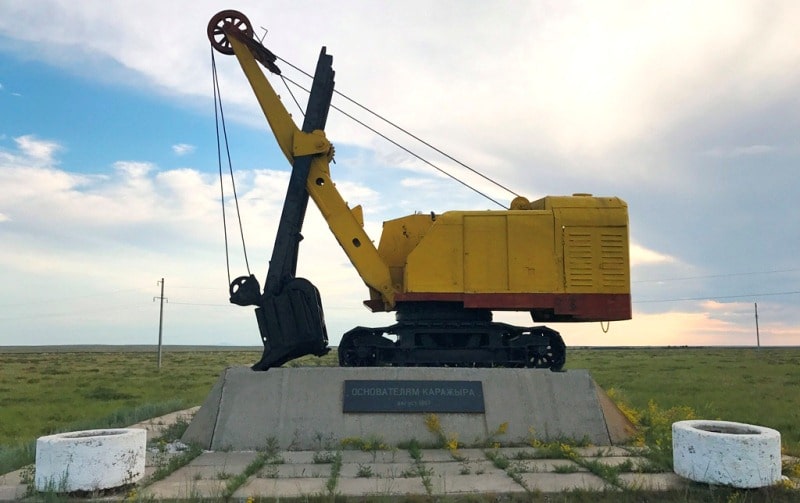
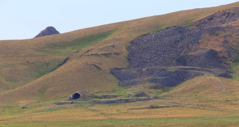
4 kilometers after the engineering structures, to the left of the road is a monument to an excavator who worked on the Karyzhar coal deposit. In 1967, a coal deposit was discovered on the territory of the Semipalatinsk nuclear test site.
In honor of the 50th anniversary of the October Revolution, it was named Jubilee.
It was explored in 1968 - 1969 by the Semipalatinsk Geological Expedition. Further work was discontinued due to the immediate proximity of the Balapan site. The area of the field, located 9 kilometers from the Balapan site, is 21.4 square kilometers.
The field is located 135 km south-west of the city of Semey in the Zhana-Semey district of the East Kazakhstan region. The industrial coal reserves of the Karazhyra deposit amount to 1 billion 231 million tons. The company produces and sells more than 6.0 million tons of coal per year.
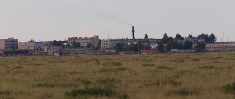
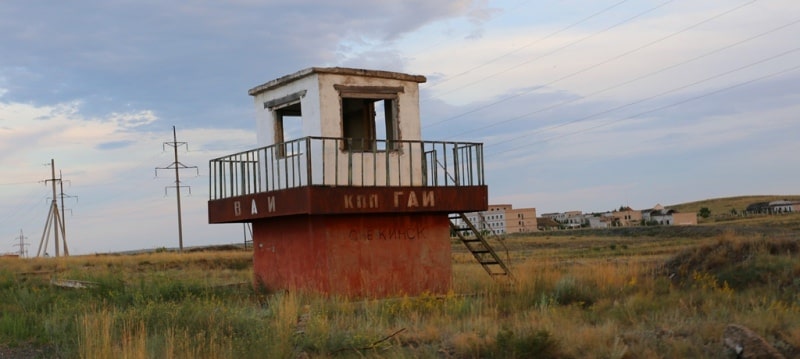
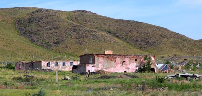
The coal of the deposit is suitable for the production of rare earth metals. Production of the mine is supplied to the population and to all TPPs of the cities of Ust-Kamenogorsk, Semey, Ridder. We are heading towards the base village of Balapan (B-2), where testers lived, of drilling and construction organizations that provided work at the Balapan site, the village is located northwest of the Balapan test site.
Now there are miners from the Karazhar coal mine. Short sightseeing tour of the village.
Transfer: settlement Balapan (B-2) - experimental site Degelen (D) (62 km).
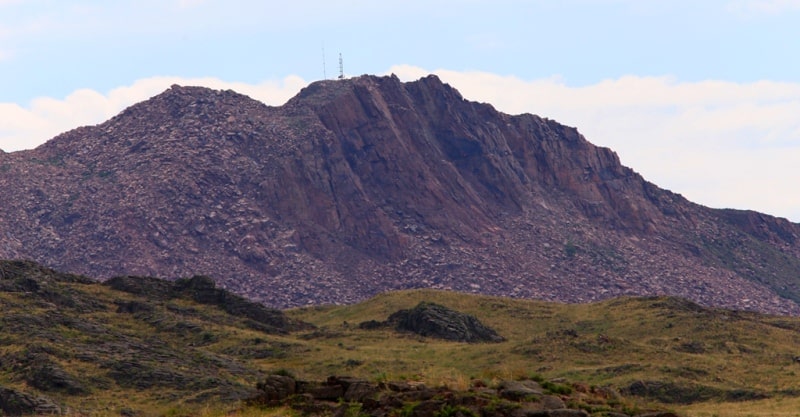
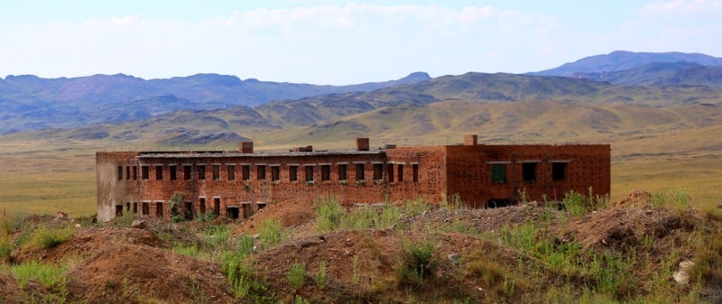
After the village of Balpan (B-2), our path lies southeast along the deserted steppe and hilly terrain. Degelen (D) is an experimental site located in the south of the underground testing ground in adits (horizontal mine workings), within the Degelen mountain range with a total area of 331 square kilometers.
It was used to carry out tests of low power (not more than tens of kilotons), as well as to solve the problems of materials science, radiation resistance) of materials, to study the interaction of radiation with matter, to develop methods for recording parameters of a nuclear explosion, etc.
The site had a production and technical base, mining and construction and installation organizations, 6 hotels for 1200 places, 3 barracks for 1100 people. The site is located on the mountain range of the same name, which is a dome-shaped uplift with a diameter of 17 - 18 km.
In total, from 1961 to 1989, 209 nuclear tests were conducted in 181 adits. The last test was carried out on 10.04.1989 in adit 169/2. Conducting underground nuclear explosions caused radioactive contamination of the tunnels. As a result of emergency situations, the portal areas of the adits were also contaminated.
From 1996 to 1998, work was completed at the Degelen site to close all adits (181) in order to exclude the possibility of their reuse for nuclear testing. The last installed nuclear charge at the Degelen site was destroyed only on May 31, 1995. In the 1990s, in the Degelen Mountains, researchers repeatedly penetrated into the cavity formed after underground nuclear tests.
The spherical shape of cavities with a diameter of several tens of meters, a characteristic column of rock collapse and a melt lens at the bottom of the cavity are described. An elevated temperature in the boiler cavity was noted decades after the tests.
The last man’s trip into the cavity of a nuclear explosion on Degelen took place on October 9, 1997 in adit No. 190, in which a double nuclear test was carried out on April 15, 1984.
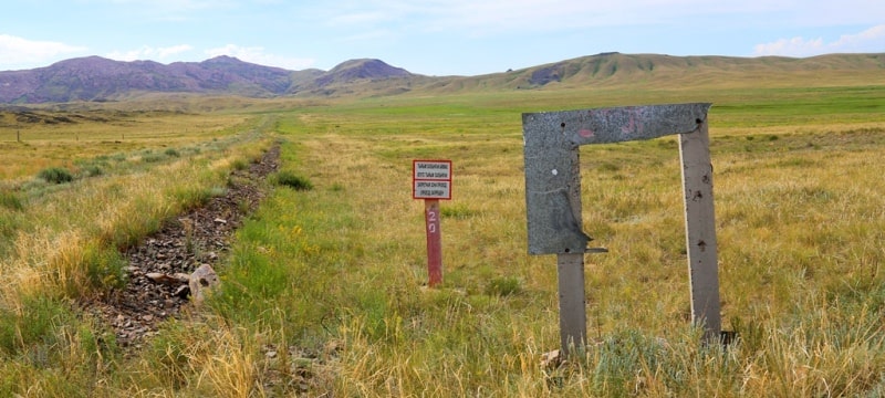
A short stop at the beginning of the Degelen mountain range, where the prohibition signs "Access and passage is prohibited."
We’ll take pictures from here.
Transfer: Degelen site - Degelen village, Point “G” (D) (10 km).
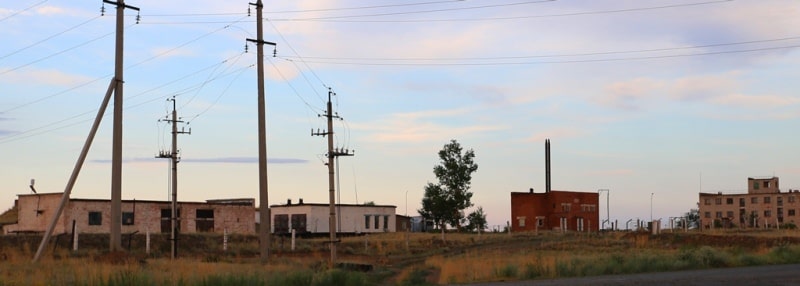
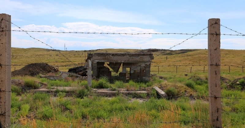
In paragraph "G" was the base village of testers, mining and construction organizations, providing work at the Degelen site, the village was located northwest of the test site. In the village, almost all the buildings are destroyed and demolished. Short stop for photographing.
Transfer: settlement Degelen point "G" - the site "Experimental Field" (D) (80 km).
After the village of Degelen (point "G"), our path lies north along the steppe, along the old grader. In the east, 25 kilometers from the village of Degelen is located "S" (the site Sary-Uzen), which is located in the southwestern part of the landfill, with a total area of 500 square kilometers.
Designed for underground nuclear testing in wells. Here 24 explosions of small power were produced for industrial purposes. "P" ("Experimental Field") is a site in the northwest of the landfill with a total area of ~ 300 square kilometers. It was used to test nuclear charges in the atmosphere (air and ground explosions).
The first Soviet nuclear tests were conducted at the “Experimental Field” in the northern part, air - 86 explosions and ground - 30 explosions, up to their ban in 1963 under the Moscow Treaty. “Experimental Field” is the heart of the landfill and its historical center.
"Experimental Field" is located on the border between the Karaganda and Pavlodar regions with a radius of about 10 kilometers. The first Soviet nuclear and hydrogen explosive devices were "dirty." Only 30 to 40% of the charge mass worked in them.
The rest of the charge, the plutonium isotope, was atomized in the atmosphere and the environment, so the “Experimental Field” was infected. The first Soviet nuclear tests were conducted at the “Experimental Field” on August 29, 1949, an atomic bomb with a capacity of 22 kt.
On August 12, 1953, a thermonuclear device with a capacity of 400 kt was also exploded for the first time. On November 22, 1955, the world's first megaton-class thermonuclear bomb was dropped. The last nuclear explosion in the atmosphere was carried out at the “Experimental Field” on December 24, 1962.
A total of 116 nuclear tests were conducted here, of which 86 - in the atmosphere, 30 - ground. The “Experimental Field” site was equipped with a large number of reinforced concrete structures with equipment for recording test parameters.
Also, around the epicenters of the explosions, a large number of structures were created - civilian (residential buildings on several floors), industrial (railway and automobile bridges, factory buildings, tunnels, metro stations) and military fortifications.
Instrument control points, the so-called Gusaks, were built here, some were felled by explosions. With the help of "Gusaks" the shock wave of an atomic explosion was measured. So far, individual fragments of instrument and fortifications with traces from the effects of nuclear explosions have been preserved.
Inspection of the main attractions of the “Experimental field”.
Transfer: platform "Experimental Field" (D) - the city of Kurchatov (63 km).
Arrival in the town of Kurchatov, transfer to a hotel, accommodation, dinner, overnight.
Day 2. Kurchatov - Semey (293 km).
Breakfast. Visit to the Museum of the History of the Semipalatinsk Nuclear Test Site. A unique museum in the city of Kurchatov was founded in 1972 on the basis of the military unit deployed on the territory of the landfill. The museum is located on the territory of the National Nuclear Center.
More than 100 exhibits are presented in the museum’s few rooms, there is a rare opportunity to get acquainted with the history of the landfill, to see photographs, archival documents, equipment used during the tests, mock-ups, information stands. The main exposition of the museum is military and scientific equipment of that time. The end of the tour.
City tour in Kurchatov, visit:
Monument to academician, nuclear physicist I.V. Kurchatov.
After assigning the city named after I.V. Kurchatov, a magnificent monument to the great scientist was erected from red granite. (Located near the akimat building).
Monument to Soldier-Liberator in town Kurchatov.
A monument to the Soldier - the Winner was built in the city. Its opening took place on May 9, 1985, on the day of the 40th anniversary of the Great Victory. Near the monument were there are memorial stands with the names of hero cities, and capsules of land brought from these cities are mounted in them.
Located this monuments the embankment of the Irtysh River)
Monumental stele in honor of military builders in town of Kurchatov.
The Builders Alley was built in 1972 in honor of the 25th anniversary of the beginning of construction work on the creation of the city and the training ground by military builders of military unit 31516. The author of the project is Honored Worker of Culture of the Kazakh and Uzbek SSR, retired major, participant World War II Korneev Georgy Alexandrovich.
Honorary citizen of the city of Kurchatov. (Located next to the youth sports school).
After the tour, transfer to Semey (145 km). Arrival in Semey, end of tour.
Note:
The water in Atomic Lake is non-radioactive. Several species of fish inhabit the lake, and fishermen fish along its shores. The waste rock formed during the explosion emits background radiation of up to 7 µSv/h.
Pieces of molten rock with beta radiation can be found on the ground. These are called "Khariton fragments," named after Yuli Borisovich Khariton, one of the leaders of the atomic bomb project.
A person can remain at any point within the test site for short periods without harm to their health, provided they protect their body and respiratory system from radioactive dust. Radiation contamination practically does not spread beyond the test site.
The main danger to humans at the test site is radioactive dust, so it is necessary to wear thick, airtight clothing, shoe covers, gloves, and respirators.
Note:
Author program is Alexander Petrov. Copying and use - from the sanction of the author.
Photos by:
Alexander Petrov.