


![]()
Вы здесь
Сave drawing of Butentau.
Petroglyphs Tours in Turkmenistan.
"They stand like idols, menhirs.
Aliens from another world.
Idols of unknown tribes.
Gods of vanished clans."
Michael Matz.
Museum Petroglyphs Tours in Turkmenistan.
Butentau (Betendag) Upland is located 19 kilometers east and slightly north of Lake Sarykamysh, between the Daryalyk and Kenederyi rivers and the ancient Gyaurchorun riverbed. It is 27 kilometers southwest of the Sabun'yol sands and 3.2 kilometers northwest of the small village of Bent in the western Turkmenbashi district in the northwestern Balkan province.
The upland extends 25 kilometers from north to southeast and southwest, with its greatest width in the northern part being 5 kilometers. The highest elevation in the southern part, near the Imam Brahim Melgam Mosque, reaches 100.3 m. a. s. l.
The northern part of the upland is at an altitude of 88.2 m. a. s. l. The Butentau plateau is bounded on all sides by cliffs, reaching a maximum height of approximately 50 meters in the southern and southwestern parts. In the northeastern part of the residual upland, the cliffs decrease to 20 meters.
The Daryalyk River flows at the foot of the northeastern slope of the Butentau plateau, and one of its tributaries, the Kichkine-Darya, flows along the southwestern slope. The Kyrk-Deshik tract is located 96.7 kilometers west and slightly south of the city of Kunya-Urgench, in the southeastern part of the Butentau plateau.
Ibrahim Medem Mosque-Mazar (Imam Ibrahim Melgam).
At the southern end of the cliff is the Ibrahim-Medem Mazar, associated with the legendary Arab Ibrahim, who, according to legend, brought Islam to this area and created the Butentau plateau in a single day. One of the translations of Butentau - "the mountain that came" - is associated with this legend.
Artificial caves are located in the southeastern and northwestern cliffs of Butentau. They are arranged in groups with large gaps (up to 5 kilometers) between them, but along the southeastern cliff, the caves form a continuous line stretching for about 3.5 kilometers.
Geographical coordinates of Ibrahim Medem (Imam Ibrahim Melgam) mosque-mazar: N42°02'34 E57°58'03
Early medieval Adak fortress (Okcha Kala).
These are the Kyrk Deshik caves. Opposite the group of caves is the early medieval Adak fortress (Okcha Kala), on the site of which the late medieval Ak Kala fortress was built, the ruins of which are well preserved to this day.
Geographic coordinates of Ak Kala settlement are: N42°03'49 E58°02'26
Butentau Kala Fortress.
At summit of Butentau, at its northern end, are remains of two ancient fortresses – Butentau Kala 1.
Geographic coordinates of Butentau Kala settlement are: N42°12'49 E58°03'39
Geographic coordinates of Butentau Kala settlement are: N42°12'41 E58°03'42
Kırk Deshik Caves.
The Kyrk Deshik Caves are carved into a marl layer 1.3-1.5 meters thick and, in places, are arranged in two tiers, approximately 5 meters apart. At the base of the elevation, thick talus, consisting of rock fragments and the products of its destruction, has formed almost everywhere.
The caves are virtually inaccessible from below and above, as they were carved into sheer cliff faces, often beneath overhanging cornices two to three meters tall. On its southeastern side, Butentau has 228 first-tier entrances and 51 second-tier entrances.
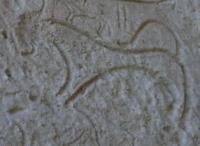
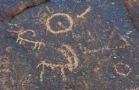
Each cave has between one and twelve entrances and between one and six rooms. A total of 91 lower-tier caves and 28 lower-tier caves have been explored. Petroglyphs are carved into rock fragments, cliff walls, and interior cave walls. In addition to petroglyphs, runic-like symbols have been discovered.
Drawings and runic symbols were cut into limestone rock with a sharp instrument to a depth of 0.1 mm to 2 cm. The stones with images, located at the foot of the hill, are covered with a "desert tan" of varying intensity. Overlapping drawings are common, which may indicate that they were created at different times.
Geographical coordinates of Butentau (Betendag) hill: N42°06'48 E58°03'29
Geographical coordinates of Kyrk Deshik tract: N42°04'07 E58°01'43
Petroglyphs near Lake Sarykamysh.
The petroglyphs near Lake Sarykamysh are diverse in both theme and style. Linear-geometric compositions predominate, and there are also images of people and wild animals. Exploration of the caves revealed various household items and ceramics from the XIIth-XIIth centuries. and a XVth-century manuscript, which determine the probable age of the majority of the rock art in the caves.
It is also suggested that some of the petroglyphs may date to earlier historical periods. (Tolstov, 1958, p. 84).
Authority:
Edjegul Muradova.
Photos by:
Alexander Petrov.