


![]()
Вы здесь
Petroglyphs of Langar.
Petroglyphs Tours in Tajikistan.
«Memory is the treasure house of the mind wherein the monuments thereof are kept and preserved»
Thomas Fuller.
Museum Petroglyphs Tours in Tajikistan.
The petroglyph site is located in the Gorno-Badakhshan Autonomous Region, in the Ishkashim District, Dzhamoat (village council) Zong, 10km south-west of the district capital Ishkashim. Langar is the easternmost settlement in Western Pamir (Badakhshan) of a series of villages located on a narrow strip of land bounded on one side by the Pyandzh River and by tall mountains on the other.
Further on, only 40km eastwards, around the place where the small Khargush River flows into the Pamir River, is the nominal border between Western and Eastern Pamir and the beginning of highland desert unfit for farming.
Geographic coordinates of the petroglyph location: NL 37 02.236, EL 72 37.321; altitude: 2,700-3,500m. Langar village is at the foothills of a spur of the Shakhdarya Range with Karl Marx Peak being its highest point (6,723 m above sea level) opposite the confluence of the Pamir River which bursts out of a narrow canyon and cuts through the high ranges of the Hindu Kush to join with the Afghani Vakhandarya River. Langar is located in the foothills of a small, but steep and narrow pass.
A traveler descending from the side of the Pamir Desert to Langar would find the first village, Badakhshan, a paradise on earth because of the drastic contrast of natural landscapes. Langar is at the crossroads of many caravan routes.
This determined the significance of the area as indicated by the abundance of rock images. In addition, the area has long been considered as the best hunting grounds in Pamir (Bobrinskiy 1908). The Tajik Archeological Expedition led by Ranov V.A. documented and studied the Langar petroglyphs in 1972; the most important images were traced on paper, described, photographed, and a topographic plan of the key locations of petroglyphs was made.
A total of 5,883 images were registered, but the total quantity of Langar petroglyphs, according to Ranov V.A., amounts to 10,000 images. Main Substrate of Rock Art Images were engraved on convex or flat and very weathered surfaces of granites, with, as a rule, horizontal, and less frequently vertical, faces.
Nowhere else on the way from Khorog to Langar is there such a concentration of relatively smooth inclined slabs so convenient for engraving. This natural point of interest in Langar also preconditioned the emergence of a true “picture gallery” in the open air that was many centuries in the making.
Most images are pecked; impact dots are 1 - 2mm deep and 3 - 5mm in diameter; the lines are 5 - 6cm wide, thicker lines being less common. Lines of earlier images are finer, straighter, and more exquisite, apparently made by a more confident and surer hand.
Dots often merge into one line, but they may be separate and then the surface appears to be spotted. The nature of the dots allows identification of the tool used for pecking. There is a difference between images pecked with a sharp metallic tool by direct impact from above or by inclined left impacts, but more often the images were pecked using a flint that left a mark with ragged edges and shallow crude chipped irregular outlines.
It is worth noting that not only later images, but many ancient patinated images were pecked with a stone tool. Only in some cases were images deeply engraved with a metal tool resembling a sewing awl or hand-punch.
There are also later images scratched with a knife. Small-sized images – 10 to 20cm – are predominant, but there are also a few images as big as 30 - 40cm. The same goes for small (up to 10cm) and larger (over 50cm) images; the smallest drawing of an animal is 6cm and the largest is 80cm.
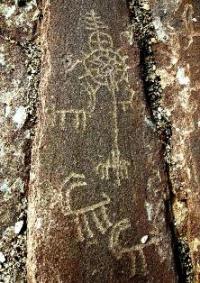
A large figure of an archer stands out on a panel named “White Figures” (1.80m), as well as an image of a musical instrument rubob (lute-like instrument) that is 1m high. Description of the Site The range of Langar images is very broad.
Therefore, researchers defined and named “image margins” –main concentrations of petroglyphs, which received numbers and names reflecting specifics of the image motifs or locations. There are small concentrations of images between these sites, also provisionally attributed to one group (“Field”) or another.
Field I was named “White Figures”; its area is about 12,000m². A total of 1,811 petroglyphs were registered. Field II was named “A Mount of Rubobs”, since about 300 images of rubobs – favorite instruments of Pamirians- were found there.
On an area of 750m², a total of 1,770 petroglyphs were registered. Field III was called “Scythian Goats”; nearly 1,000 petroglyphs were found there. Unlike the two previous fields, these images are arranged in small groups at a distance of about 500m.
Field IV is named “Inscription”; a total of 779 petroglyphs were found there. The main surface with images has an area of 10m². Field V received a name, “Near a Flag”, in 1972, because border guards hoisted a USSR flag a little above the place.
A total of 523 images were found there on an area of 200 x 50m. One more field with a smaller area, 1А, was discovered in 2001. The concentration of petroglyphs is located on the eastern slope of the Kishtirdzharv fissure almost opposite Field 1.
The number of images was not determined. The repertoire of Langar petroglyphs includes four groups of images. Mountain goats –nakhchirs – are the most numerous: 3,511, sometimes in scenes of hunting herds (up to 15 images of animals per scene).
Other wild animal images include snow leopards, deer (including Bactrian tugai deer – Cervus claphus bactrianus), animals from the Bovidae family and a bull. Human images are sketchy and resemble a cross. Horse riders with sabers are shown on one of the rocks. Some humans’ bodies are represented as triangles with connected vertexes.
There are images of Buddhist Stupa, tamgas of various forms, signs, circles (sun signs) and open palm (Ismaili symbol). Images of rubobs are numerous. Dating Langar petroglyphs belong to different chronological periods, with images of the Bronze Age – 1st millennium BC, Kushan and Ephthalite period (early 1st millennium BC), the Middle Ages (IXth - XVIth centuries), as well as the Late Middle Ages and modernity (XVIIth - XXth centuries).
Images of rubobs with a special type of chipping are dated to the 1st century AD. Archeological Context Mountain roads leading to Fergana and China, Afghanistan, Pakistan, and India meet there. Although the roads were difficult and dangerous, there was one branch of the Silk Road; the Vakhan part of the road, which connected many centers of the ancient world and played a very important role for many periods. It is not improbable that the Vakhan route helped Buddhism make its way to China.
Stone Age sites were found in Western Pamir: Shugnou site (35 - 20 millennia BC), location Dzhaushangoz I (VIIIth - Vth millennia BC). Bronze Age sites: burial site Dzhaushangoz VII, rock art Namdgut, rock drawings at Darshay III.
Sites dated to the Early Iron Age include various fortresses, tuphona, burial sites, fortified settlements, and locations of petroglyphs: Chasem I, Miyonakuh I, Dzhaushangoz VI, Dzhaushangoz VII, Chilhona, Ratm I, Ratm II, Vybistdara (rock drawings), Richiv, Darshay III (rock drawings), Yamchun I, Yamchun II, etc.
Authority:
Bobomullo S. Bobomulloev.
Photos by
Surat Toymasov.