


![]()
Вы здесь
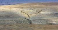
Bed of river Uzboy.

Trip along bed river of Uzboy.
“In 1846, the centurion (yuzbashi) Muhammad Emin, on behalf of Khan Muhammad Emin, built a dam on the old riverbed, conducted water and set up a garden half a day's journey south of Old Urgench. In 1847, the khan himself came there, made sure that the area was suitable for agriculture, ordered to expand and lengthen the canal; people from karakalpa were called for these works”
V.V. Bartold. "On the history of the irrigation of Turkestan."
Sights of bed river Uzboy.
For science, the fact of the disappearance of the river, which once flowed along Uzboy, is now quite obvious. The Amu Darya changed its course, all the water went to the Aral Sea, the region became a desert. Only gerbils, foxes and thin-legged Karakum antelopes disturb the peace of dead territories.
The first of the scientists who proved that Uzboy is a river channel was Vladimir Afanasevich Obruchev. In 1886 he left for Turkmenistan, or, as they wrote then, the Trans-Caspian region. This was the first expedition of an outstanding geologist and geographer who showed that Uzboy was an independent river flowing from the Sarykamysh depression and flowing into the Caspian Sea.
Prior to the expedition, V. A. Obruchev did not know about the origin of Uzboy. Some believed that this was a strait along which the Caspian and Aral waters were exchanged, while others claimed that Uzboy was a ravine created by torrential streams, which are many, for example, in the Sahara, where Arabs call them Wadi (Wadi).
Such a point of view was held by K. Bogdanovich and the German scientist I. Walter, who had studied the deserts of the world for many years and wrote the famous work "Laws of the Formation of Deserts." The expeditions of the Institute of Geography of the Academy of Sciences of the USSR in 1934 confirmed the ideas of V. A. Obruchev.
Geographers have found that Uzboy is indeed a well-preserved bed of a large river that once crossed the Trans-Caspian deserts, but that this river and the Amu Darya are not the same thing. The Amu Darya, with its size, could not accommodate even half of its waters in the Uzbek channel.
Uzboy was an independent river, which had a beginning in Lake Sarykamysh. It flowed into the Balkhan Bay of the Caspian Sea. Sarykamysh lake was fed part of the waters of the Amu Darya. Thus, Uzba can be compared with Volkhov or Svir, that is, river-channels between the lakes.
Then did the water flow along Uzboy stop, when did its valley, so well preserved to this day, become dead? Archaeologists have helped to answer this question. The ruins of ancient settlements along Uzboy, about which historians wrote a lot, turned out to be the remnants of caravanserais that served the ancient path to Khorezm.
The "water supply" at the large takir and Akyail well, it turns out, was functioning when there was no water in Uzboy anymore, the gutter sloped obliquely towards the channel and could not raise and supply water from Uzboy.
The traces of agriculture by Uzboy a short time ago are insignificant agricultural plots that were irrigated with water from fresh Uzbek lakes or by collecting takir waters. There were no large irrigation sites in ancient times.
So say archaeologists. “The questions of Uzboy, I think, should leave historians and remain the sphere of geographers, geologists and primitive archaeologists,” writes Professor S. P. Tolstov. In another, later work, the same author believes that the main cause of Uzboy’s death was the creation of a ramified irrigation system in Khorezm in ancient times, which required an enormous amount of water, which led to the drying up of Sarykamysh Lake.
Thus, archeological data say that by the beginning of the first millennium BC, Uzboy existed as a living river. Antiquity was a period of drying out. The evidence of Abulgazi, according to archaeologists, does not refer to Uzboy, but to Daryalyk [Kunyadarya], according to which Amudarya water really breaks out in our time.
The Khorezmian historian was right when he wrote about the dense population, numerous herds of animals and green arable lands located along the Uzboy valley. According to S.P. Tolstov, nomadic Turkmen were based here, who from time to time went into the depths of the desert.
Among the Eastern writers of the Middle Ages there is no consensus on the time when water flowed along Uzboy. Studying the Khorezm and Arab sources and referring to Abulgazi, the famous Russian orientalist V.V. Bartold believed that in the Middle Ages Uzboy was a living river until 1573, when the flow of water stopped.
But the geographer of the 14th century Omari wrote: “Ceyhun [Amu Darya] turns into a salt lake, into which the Shashskaya [Syr Darya] river flows. Whoever believes that Jeykhun flows into the Sea of Caspian [Caspian] is mistaken; it seemed to him that only because of the size of this lake."
How is the question solved at what times the Uzboy was a living river and at what dead. In recent years, scientists working in the Sarykamysh depression discovered traces of water-lifting structures and an ancient but clear network of irrigation grooves on its slopes.
What waters could farmers irrigate arable land? After all, there are no rivers or fresh lakes around. Residents could take water only from the ancient Sarykamysh Lake, which, and this is indisputably, was fed by the Amu Darya, which gave part of its supplies through the western branches.
Only in recent years has the picture of the recent life of Uzboy and Sarykamysh Lake become clear. Indeed, in the 15th and 16th centuries the Amu Darya carried some of its water to the Sarykamysh depression. When the lake level reached the drain horizon, water flowed into Uzboy, and the river came to life.
Thus, the Amu Darya water reached the Caspian Sea. The life of Uzboy depended on how much water Amu Darya dumped into Sarykamysh. When the level of Sarykamysh Lake fell, the river in Uzboy died, the level rose again - and the river again flowed to the Caspian.
Thus, in Uzboy, water was flowing only at times, inconstantly. This should explain the presence of traces of irrigation systems on the slopes of the Sarykamysh depression and the absence of medieval archaeological sites and traces of ancient arable lands and irrigation canals along the Uzboy valley.
The ancient Sarykamysh delta of the Amu Darya was irrigated by its waters in the Middle Ages, the so-called lands of ancient irrigation stretched here. And the old channels lying to the west of Khorezm, the channel of the ancient Amu Darya delta, about which we wrote, really carried water several centuries ago.
Large fortifications and traces of developed architecture were preserved here. And in our time sometimes the river seems to recall its ancient, abandoned path. During particularly large floods, it breaks the banks, rushes along the old channels, irrigating the dry, cracked clay of the plains, and sometimes brings water along the Kunyadarya riverbed (which in Turkmen means “old river”) to Sarykamysh itself. In 1878 there was a very strong breakthrough when water flooded the lowest parts of the basin and formed lakes up to eight meters deep.
The flood passed, the river level dropped, and everything remained as before, as before the flood. Under the scorching rays of the sun, water dried up in Sarykamysh, salt marshes reappeared; only the wells in the Kunyadarya valley for a long time kept tasty cool water.
More recently, in 1930, during a large spill, the Amu Darya waters broke through in the old rivers of the Kudarya and along it reached Lake Sarykamysh. It would seem that how many good lands with fertile soils are waiting for their development in the north of the republic, in the Tashauz region - in the ancient Sarykamysh delta of the Amu Darya, where now the waters of this river do not reach.
If many desert places located west of the oasis of Khorezm were irrigated, then not one thousand hectares of barren land would bloom and bear fruit. But does it make sense to do this? In recent years, objections to such projects have been voiced.
However, let us not rush to condemn them. Better listen to the pros and cons. Should we use the land of ancient irrigation in our era, when technical equipment and scientific thought allow us to solve irrigation issues differently than our ancestors did a thousand, two thousand years ago?
It would seem that the answer is simple. “Yes, it follows!” - answer archaeologists and historians who have studied the lower reaches of the Amu Darya and Syrdarya. Why not, if these lands provided agricultural products.
It is enough to bring water from the lower reaches of these rivers to empty fields, as they again bloom with a bright carpet of greenery. And here there are contradictions and doubts. First of all, the question of the advisability of the widespread use of ancient irrigation lands in the deltas of the named large rivers of Central Asia and Kazakhstan in the modern era should be answered.
Their lower reaches are located in the north of the desert zone; here there are incomparably less heat resources than in the south of Central Asia, where during the growing season the sum of effective temperatures reaches record values for the USSR.
In Khorezm, the sum of air temperatures for a period with a stable temperature above 5 ° is equal to 4200 - 4500 °, while in the extreme south of Turkmenistan, Uzbekistan and Tajikistan it reaches 5600 - 5800 and even 6000 °.
It is in these southern border regions that the most valuable late-ripening cotton varieties can be successfully cultivated. It turns out that it is economically more profitable to build new irrigation systems not on the lands of ancient irrigation in the lower reaches of the Amu Darya and Syr Darya, but in the upper and partly middle areas of their basins.
There are many land resources in Central Asia and Southern Kazakhstan, but it is impossible to irrigate them with available moisture reserves. By directing river water to irrigate areas in the upper and middle regions of river basins, we thereby doom their lower reaches to waterless or hungry rations.
At the same time, the possibility as well as the feasibility of the future existence of the Aral Sea is being questioned.
Literature:
S.P. Tolstov. In the footsteps of the ancient Khorezm civilization.
Authority:
"Years of searching in Asia." Murzaev Eduard Makarovich.
Photo
Alexander Petrov.