


![]()
Вы здесь
Kokzhide-Kumzhargan Nature Reserve.
Photos of nature of the Aktobe region.
"The tree is bitter in nature
If you plant in the Garden of Eden
If from a paradise during irrigation
Pour honey and pure sweetness on its roots
In the end he will show his nature,
The same bitter fruit will bring”
Firdousi.
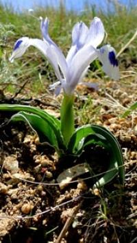
Tours for Schrenk's tulip in the Aktobe region.
State integrated nature reserve "Kokzhide-Kumzhargan" is located in the Mugalzhar district of Aktobe region. The motivation for organizing the Kokzhide-Kumzhargan integrated nature reserve was the preservation of natural complexes and the unique, vital facility of the Republican significance PZF - Kokzhide sands, the basis for the formation of the cleanest fresh water reservoir in Western Kazakhstan, which plays an important role in providing drinking water to settlements and shift camps in the region.
Preservation of a unique relic tape forest massif on the border of Kumzhargan sands and the Zhem river valley. Here is a key ornithological territory as a nesting place, resting on the flight of migratory birds; goes the way of seasonal migrations of the Ustyurt saiga population.
he relief of the elevated, slightly dissected plain, crossed by the valley of the Emba (Gem) river and its tributaries Temir, Atzhaks, channels of temporary streams Kumzhargan, Taldy, ravines and gullies. On the right bank of the Zhem River, there are massifs of relict cellular, semi-fixed, and mobile Kokzhide sands and fixed and semi-fixed tuberous sands of Kumzhargan.
Sands are lumpy-cellular, the height of sandy mounds is 4-8 m, the slopes are gentle (up to 10 °).
Semi-fixed sands stretch in a wide strip along the river, a significant area of sand is not fixed. The hillocks are arranged randomly, sometimes elongated one after another, forming short chains. The chains of tubercles articulate and intersect at different angles, sometimes almost perpendicularly, forming a cellular structure with micro hollows in the center.
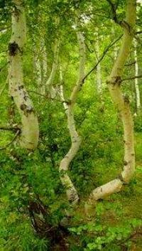
In depressions between the hillocks - cells, closed systems of condensate, melt and rain water accumulation are formed and, as a result, special conditions of moistening. Depending on the size and depth of the cells, shrub-tree communities are formed in them, which is clearly visible in the photographs.
In large cells of the Kumzhargan massif, ring associations of vegetation are formed - from reed in the center to tree-shrubby outskirts. Natural distribution of poplar and aspen is observed on the bottoms and slopes of sandy hillocks in the Kumzhargan massif.
The climate is sharply continental, characterized by high summer temperatures - the average July temperature is +23 + 24 ° С and mild winters -14 - 16 ° С. The average annual air temperature is +3.0 + 6.0 ° С. The sum of temperatures above 10 ° C is 2700 - 3000 ° C; the average annual rainfall is 200 - 240 mm; the frost-free period is 160-180 days; hydrothermal coefficient 0.5 - 0.6; humidification coefficient 0.20 - 0.30.
The average annual wind speed is 4 - 4.5 m / s, winds of the south, southeast direction prevail. Surface waters are represented by the river Zhem and its tributaries. The river begins on the western slope of the Mugalzhar Mountains and is lost among salt marshes about 5 km from the Caspian Sea in the Atyrau region and reaches the Caspian only in rare wet years.
The length of the river is 712 km, the catchment area is 40.4 thousand km2. The river along its entire length takes 12 tributaries with a length of more than 30 km, of which the largest is the river. Temir is 212 km long.
Mineralization of water during the flood period of 0.18 - 0.20 g / l, and in the low water in the upper reaches 0.65 g / l, and in the lower reaches it sometimes reaches 1.0 g / l, less often more than 1 g / l. The riverbed is meandering, meanders.
The shores are gentle in places, steep in places. Brody 0.5 m deep are found throughout the river. Food - due to snowmelt. It freezes in early December, opens at the end of March. During high water, the water rises above the average level by 1.5 - 2.0 m, but falls off within 5 - 7 days.
Groundwater is confined to aeolian deposits of fine and medium-grained sands with a thickness of up to 10 - 15 m. The water in them lies at a depth of 0.5 - 1 m in depressions to 5 - 15 m under the hillocks. Levels during the year are subject to significant fluctuations.
The water yield of the sands is low - flow rates range from 0.01 to 0.3 l / s with a decrease in water level by 0.5 - 1 m. In the riverine zones, water consumption increases to 0.4 - 0.6 l / s. Groundwaters with mineralization from 0.1 to 1 g / l of bicarbonate or sulphate-bicarbonate calcium or sodium composition circulate in waving and weakly fixed sands.
More mineralized waters (2 -3 g / l) occur in the thickness of the fixed sands; the composition is sodium sulfate or sulfate-hydrocarbonate. The waters of alluvial deposits in the Emba Valley lie from 0.5 - 5 m in the floodplain and on lower terraces to 15 - 20 m on high.
The composition is mainly bicarbonate, bicarbonate-sulphate calcium or calcium-sodium, mineralization of 1 - 2 g / l. The soil cover is represented by sand and light chestnut soils, characterized by a low thickness of the humus horizon, low humus content, and poor structure.
Genetic horizons in the sands are not expressed at all. However, in the upper layer there is some accumulation of humus (0.1 - 0.2%). Animal world. The basis of reptiles is a desert complex, represented by 12 species. During migrations (April - May, end of August - October), the number of birds increases.
Here one of the main migration routes of waterfowl and near-water birds passes. Depending on the amount of water, birds can linger here until the end of May - mid-June. Of the mammals, the most numerous is the group of rodents.
Authority:
Natural resources of Aktobe region. Ecoproject LLP. 216 p.
Photos
Alexander Petrov.