


![]()
Вы здесь
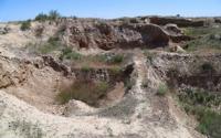
Kumkent ancient settlement.
Holiday Tours in Turkestan.
“It was up this causeway that the Tajik ancestors, the Sogdians, had fled from Arab invaders in the eighth century. For more than fifteen hundred years they had lived along the Zerafshan in a loose-linked galaxy of oasis princedoms. Rut Turkic and Arab incursions at last confined them to the great cities, where their Tajik descendants survive, or drove them deep into the mountains, and the valley which we followed still seemed to echo their desperate migration”
The Lost Heart of Asia, Colin Thubron.
Travel Tours from Shymkent to Atyrau.
The Kumkent ancient settlement (VII - XV centuries) is located on the southern outskirts of the village of Kumkent in the Sozak district of the South Kazakhstan region. Kumkent (Kumly-Kala) is mentioned in the events of the XIII - XIV centuries, primarily in the epic about Edig, which refers to the ruin of the city of Tokhtamysh at the end of the XIV century.
The town was also mentioned as Kaikan in the records of the Armenian king Getum I, who was returning from Karakorum to his homeland. Judging by the Getum route and the list of cities through which he passed, Kaykan corresponds to the city of Kumkent, located on the northern slopes of Karatau, 30 km east of the village of Chulak-Kurgan.
G.I. Patsevich also identifies the ancient town of Kumkent with the medieval town of Koykand, which in 1256 visited the Apian prince Getum on the way to the headquarters of the Mongol Khan Mengu. Mentioned in scientific literature at the beginning of the XX century. (V.P. Kolosovsky).
Surveyed by the Central Kazakhstan Archaeological Expedition (A.Kh. Margulan) in 1946, the South Kazakhstan Archaeological Expedition (A.N. Bernshtam) in 1947, and in 1957, an exploration excavation was established by the South Kazakhstan Archaeological Expedition (E. I. Ageeva).
Monument topography: in plan it is a 3-tier mound of square shape with littered corners, stretched from north to south, has dimensions - base 450 x 300 m., Upper platform (remnants of shakhristan) 200 x 160 m, height in the northern part 14 - 15 meters, in the south - up to 20 meters. In the southern part of the settlement - the remains of the citadel in the form of an elevated platform measuring 28 x 30 meters. Shakhristan from the north adjoins the remains of a slave of triangular shape with a height of 3 - 4 meters, a size in the middle part of 40 x 50 meters.
The hillfort from 3 sides is surrounded by a shaft 2.5 - 3 meters high and 2-3 meters wide. On the outside of the shaft there are traces of a moat. Around the ancient settlement in a vast area are traces of an ancient irrigation network and the remains of various household and residential buildings of the Middle Ages.
Excavations revealed the architectural features of a manor-type residential building constructed from raw brick and blocks; traces of foci, floors and walls have been preserved. Numerous ceramic material - fragments of vessels of various shapes and functional purposes (humas, carafes, jugs, dishes, mugs), ornamented with drawn wavy and straight horizontal lines; there is decor in the form of stucco rollers and streaks of light brown.
A signet ring and a small jug half-filled with grape grains were found, as well as stone and ceramic spindles, sharpeners, fragments of grain grains. The geographic coordinates of the fortification N 43` 45.573`: E 069` 36.338`
Authority:
"Code of monuments of the South Kazakhstan region." Architectural and archaeological heritage of the South Kazakhstan region. In the framework of the regional program "Cultural Heritage". http://www.farsah.kz
Photos
Alexander Peetrov.