


![]()
Вы здесь
Petroglyphs of Koshkar-ata
Cave paintings of South Kazakhstan region.
Nature lives and moves.
They grow, mature, grow stronger in them
Both states and peoples.
Periodic Law.
Life-giving idea.
Watch the running of the measured waves
Before the Secret Awe”
P.N. Savitsky. "Number and measure".
Cave draiwing of Kazakhstan.
Petroglyphs of Koshkar ata are located in the Tegistyk gorge, in the northeastern part of the Akkuz mountains on the eastern slope of the Syrdarya Karatau ridge, 19 kilometers southwest of the village of Sozak, 18.5 kilometers west of the village of Syzgan and 22 kilometers southeast of east of the village of Karakur in the Sozak district of the Turkestan region.
The petroglyphs got their name from the valley Koshkar ata located 2 kilometers to the southeast from the beginning of the rock paintings in the Tegistyk gorge. Petroglyphs were found mainly in the foothill valley and in much smaller numbers in the gorge itself.
The largest group of rock carvings is concentrated on a flat-topped remnant protruding far to the north from the main axis of the Greater Karatau and its frames. Topographically, this location resembles the Koibagar - I group, located 21 kilometers to the east.
The remnant, as in Koybagar - I, is covered with Quaternary deluvial-proluvial deposits and stretches for 700 meters along the Koshkar ata River parallel to the gorge. Its height is 70 - 80 meters. On the slope facing the river, 22 burial mounds were registered.
The rock carvings are carved on blocks and small fragments of garnet shales located on the southeastern, eastern and partly western slopes, closer to the top of the remnant. The stones were counted in a circle from the southern point of the eastern slope.
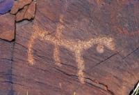
The plots in the petroglyphs of this group are close to the Koybagar engravings. They are dominated by figures of goats, argali, camels, horses. Lots of pictures of people. There are few multi-figure compositions.
This is due to the small number of large canvases suitable for multi-figure knockouts. The most common plots are: camels led by people, riders on horseback, scenes of dogs chasing goats. In three cases, chariots are carved on the stones.
All of them are drawbar, drawn by horses. One shows a chariot with four spokes in the wheels. And in the composition on another stone, small wheels are indicated by a solid knockout. In the latter case, a man with his hands raised up was knocked out behind the chariot.
Wild boars are shown twice. Their figures are conditional, their heads are hypertrophied. A complex composition, including about 100 images, is carved on a large boulder, where kulans, people with their arms spread apart, horses, camels and other figures are depicted, which are difficult to distinguish due to poor preservation.
In several cases, spectacle-shaped signs, circles with four and nine spokes are carved, occasionally there are images of snakes and a sun-headed deity. A significant part of the rock carvings has been renewed, moreover, relatively recently.
This can be seen in the patina. Such fresh engravings have a very light color. On separate stones, fresh images are carved next to the ancient ones and copy them. In imitation of the ancients, images of a domestic bull, a horse with a saddle and a dog are engraved.
The scenes and separate images described above include not only the petroglyphs of the western extreme remnant, but also those that are in the lot between it and the second, eastern, remnant and partly on the northern slope of the latter.
All these images are distinguished by their relatively small size (from 5 to 50 cm) and shallow embossing. The depth of the knockout ranges from 2 to 5 mm. Knockout is large-dotted, small-dotted is rare. Most of the engravings are done roughly. Almost all images are in silhouette.
Geographical coordinates of Koshkar ata petroglyphs located on the right side of the Koshkar ata river: N44°00'17.14" E68°19'05.13"
Geographical coordinates of petroglyphs of Koshkar ata located in Tegystyk gorge: N43°59'00.05" E68°16'56.44"
Authority:
The book "Petroglyphs of the Karatau ridge", authors M.K. Kadyrbaev, A.N. Maryashev.
Photos by
Alexander Petrov.