


![]()
Вы здесь
Imantau lake.
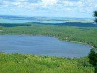
Photo tours to park Kokshetau.
“A good traveler has no fixed plans and is not intent on arriving”
Lao Tzu.
Photo Gallery Kokshetau park.
Imantau lake (Kazakh - Imantau kөli) is located at an altitude of 323 meters above sea level. It is located in a forest in the Ayyrtau district of the North Kazakhstan region in the territory of Kokshetau National Natural Park.
The length of the lake is 13.4 kilometers, the largest width in the northwestern part of the lake is 5 kilometers, the lake is stretched from the northwest to the southeast. Imantau Lake belongs to the Ishim River Basin in the Aiyrtau District of the North Kazakhstan Region.
The average depth of Lake Imantau is 5.7 meters, the maximum is more than 10 meters. The catchment area is 483 square kilometers. The southwestern shore is high, steep, Imantau Mountain, 621 meters above sea level, is adjacent to the lake, the rest of the shores of the lake are shallow.
The northwestern part of the lake is separated by a cape. In the southern part of the lake is the rocky island of Tasaral. Reed and reeds, aspen and birch forests grow on the coast. The composition of the water is hydrocarbonate, mineralization - 0.78 - 0.84 g / l.
The Imanburlyk River flows from the lake. In the lake there are a mackerel, ide, perch, pike, mirror carp, crucian carp. On the southeastern shore of the lake is the village of Imantau.
Authority:
"National Encyclopedia". Almaty "Kazakh encyclopedias." 2005 .-- T. II.