


![]()
Вы здесь
Kokshe Tau mountains.
Tours in mountains of Kokshe Tau.
“I’ve got used to the proud mountains of Kokshetau since childhood,
He strove for them, understanding their native language,
Yes, in the lakes I washed and watered a horse,
It has long been prone to these mirrors of Arches,
There’s a talnik here that fingers of a girl’s hand,
Like innocent babies, pine cuttings,
All lakes of Kokshetau - take a look to the bottom.
In fur coats live clear pupils"
Baluansholak (Nurmagambetov).
Trip from Almaty to Kokshetau.
Kokshe Tau mountains are located in northeastern part of Kazakh hilly area in western part of Burabay low-mountain massif on territory of the "Burabay" natural park in Burabay district of Akmola region.
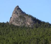
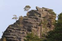
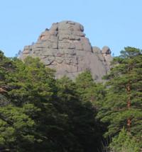
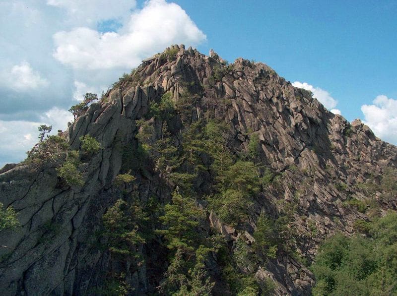
Kokshe Tau mountains rise in the northeast of the Kazakh hilly area among the Kokshe Tau upland, which is based on the ancient Kokshe Tau block, which is still experiencing tectonic uplifts. The mountains are composed mainly of granites, the weathering of which creates bizarre landforms, including in the form of mattresses lying one above the other (mattress-like units).
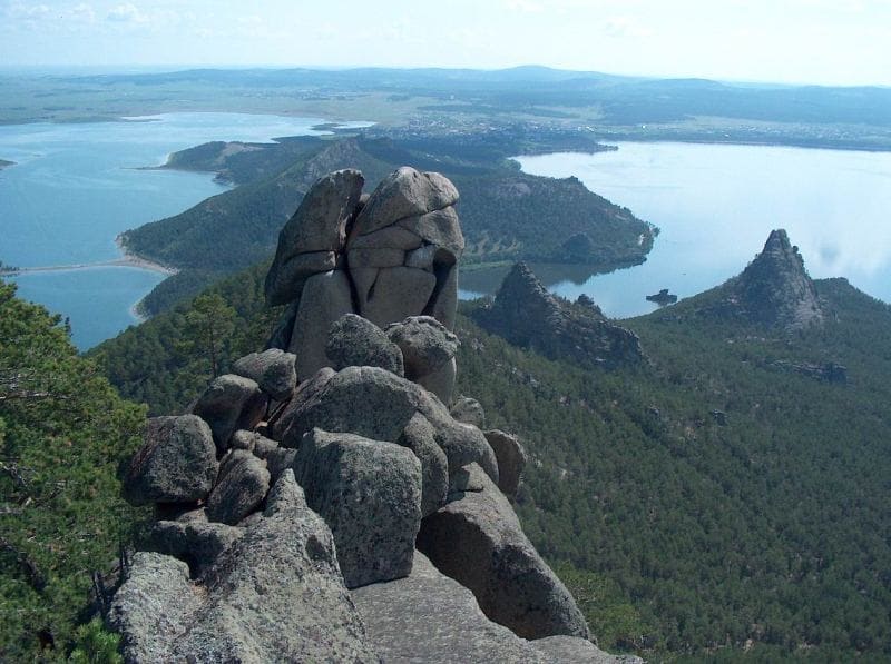
The upland landscapes of granite low mountains are very picturesque. Special beauty is given to them by “deep transparent lakes located at the foot of the mountains and the ruinous relief of weathered granite rocks, forming bizarre statues and chaotic heaps” (Gvozdetsky, Nikolaev, 1971, p. 152).
"At first, it seems like a mirage. After long hours of driving along the dry, flat and almost waterless steppe, the endless wheat fields of rare elevators, dark green mountain slopes and a spacious blue expanse of the lake with granite rocks on the shores appear outside the train window.
A cozy white town at the foot of high hills covered with pines and birches meets the northernmost oasis in the steppes of Central Asia traveling across Kazakhstan - an amazing and dissimilar region named Kokshe Tau. Geographers often call Kokshetau a hill.
The highest mountain Sinyukha - its height is less than a kilometer. Whoever travels with a backpack through the coniferous aroma of the forest trails of Kokshe Tau and climbed steep granite hills, wade the stony river beds and sailed on a boat into the picturesque bays of calm lakes, the country “Kazakhstan Switzerland” will always be closer.
This poetic name determines the appearance of a unique corner of nature, abandoned from another world here, in the heart of the Kazakh steppes. Sinegorye (as Kokshe Tau is translated from Kazakh) is located on the northern outskirts of the Kazakh small hills and extends two hundred kilometers from north to south and four hundred from east to west.
Above the surrounding area they rise only 300 - 600 meters, composed of massive crystalline rocks, crowned with pointed crests and covered with pine birch forests, these ridges of mountains create an enchanting semblance of a mountain landscape.
Its beauty is complemented by numerous lakes, spread out in the hollows between the mountains or at the foot of hills. A favorable climate, plenty of water and rich hunting grounds have long attracted people here. Archaeologists have discovered here the Stone Age sites and the remains of the dwellings of the Bronze Age.
In the second half of the XIXth century, in the center of the mountains, near Lake Burabay, the first national resort was founded, where healing mineral springs and healing mud combined with cool summer weather and pine air cured lung diseases, sciatica, arthritis and other diseases.
Today, many tourists come to Kokshe Tau from Siberia and the Urals. A small town, on the shores of Lake Shchuchye, is surrounded by wooded hills, between which there is a highway leading north to Burabay. A beautiful forest road winds among stone mountains, descending into the hollows and climbing hills.
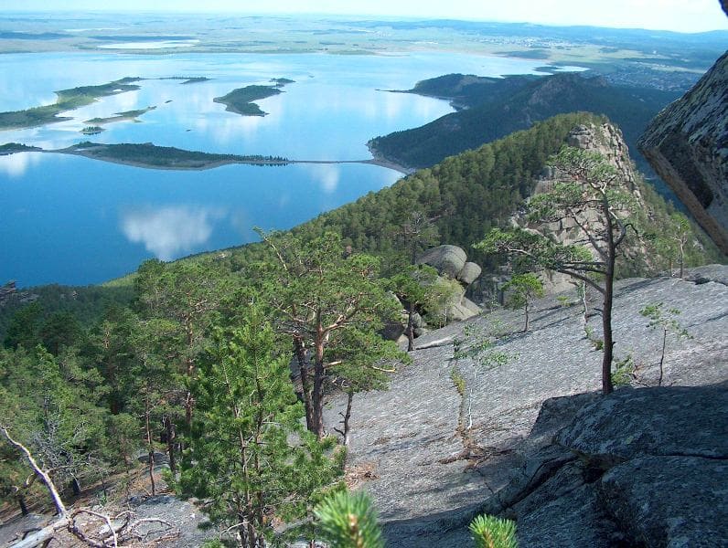
Rocks can be seen between the trunks of pine and birch trees, and springs with cold, tasty water break through nearby, at their foot. Twenty kilometers from Schuchinsk, from the next pass, a spacious lake surface opens below. The resort village lies on the isthmus between the lakes Big Chebachye and Burabay, not far from Mount Kokshe Tau (Sinyukha).
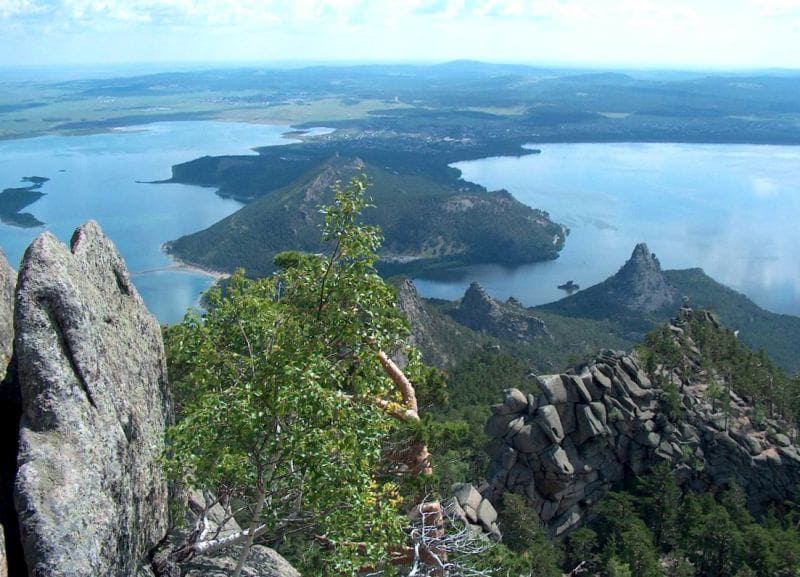
Climbing to its peak, 950 meters above sea level, allows you to enjoy the magnificent panorama of the surrounding countryside. To the north from the Kokshe Tau (Sinyukha) ridge to the horizon stretch steppes with rare lakes, in the south forests extend.
In the western part of this mountain forest, a half-ring with a length of more than twenty kilometers lies rocky ridges of Kokshe Tau, in the southeast they abut Shuchye Lake, from the west they bend around Small Chebachye Lake, and the northeastern end of the Kokshe Tau (Sinyukha) Ridge between Big Chebachye and Burabay Lakes.
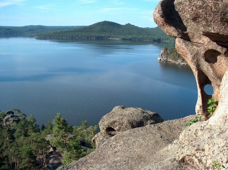
These are the largest bodies of water. In fine weather, up to seventy lakes can be counted from the top. The largest of them is the Big Chebachye with an area of about twenty-five square kilometers and a depth of up to forty meters.
Borovoye is almost twice as inferior to him; it is considered the most beautiful in Kokshetau.
The water in Lake Burabay is soft and transparent, even at great depths schools of fish and granite pebbles at the bottom of the lake are clearly visible. On the northern rocky shore of the reservoir, bathing enthusiasts expect natural flat granite slabs that look like mattresses.
An extensive sandy beach with pine trees stretches along the southern coast of Burabay. If you go along the Gromovaya River flowing into the lake to its source, you find yourself in an unusual birch grove. The trees in it are bent by winter winds, as if the plants spun in an outlandish dance.
You can admire Burabay's landscapes for hours: the water surface of the lake, the bizarre architecture of rocks and mountain ridges. In the middle of the lake there is a picturesque rock island "Sphinx", similar to the ancient Egyptian sculpture of the Valley of the Pyramids.
On the northern shore, against the backdrop of the forest slopes of Kokshe Tau (Sinyukha), there is a cone of Okzhetpes rock (in Kazakh - “No arrow will reach”), crowned with a stone statue resembling a lying elephant. In the vicinity of Borovoy hiding mysterious and deep caves in which robbers hid.
On the slopes of hills and the shores of lakes there are bizarre cliffs, many of which folk fantasy has appropriated their own names. On the crest of Kokshe Tau (Sinyukha), for example, the Three Sisters cliffs are rising, following each other. In the west, amid the forest and mountains, the profile of the rock "Sleeping Knight" looms.
Beautiful and wise legends are made by Kazakhs about each of these rocks or caves. 500 kilometers southeast, from Karaganda to the deep Irtysh, there is another island of pine forests and rocky hills - this is the famous Karkaraly oasis.
The steep, rocky slopes of the mountains, on which pine and birch are miraculously held, look more severe and outlined than the Kokshetau hills.
The mountains themselves are higher here - up to 1400 meters. Therefore, many lakes here resemble Altai or Tien-Shan ponds. The most famous of them is Shaitankol Lake ("Devil's Lake"). If you drive 150 kilometers north of the Karkaraly mountains, you can see the third natural pearl of the Kazakhstan steppes - Bayanaul mountains.
This is the smallest of the three granite massifs, towering above the plain on the left bank of the Irtysh. Bayanaul forests, mountains, caves and lakes are also covered in legends, but, having visited Kokshetau, you still perceive both Karkaralinsk and Bayanaul as just a reduced repetition of this fabulous country of green mountains of fantastic rocks.
The area of the Karkaraly mountains is about a thousand square kilometers, and the mountains of Bayanaul - half. Kokshe Tau is the best object for excursions. Traveling through them, unnoticed by yourself, you begin to love this nature, you give him a particle of your soul.
The pine land of a thousand cliffs and seventy lakes enters your mind with a poetic and colorful vision of an unusual and beautiful world. And in memory the harsh stone sphinx appears again and again, painted with a pink brush of sunset on the turquoise canvas of Lake Burabay..."
Geographical coordinates of Kokshetau mountains: N53°01'59 E70°08'40
Authority:
"100 great wonders of nature." Bertil Wagner. http://fisechko.ru/100vel/chud_prir/50.html
Kokchetav upland. TSB "Great Soviet Encyclopedia" (in 30 volumes) ch. ed. A. M. Prokhorov. - 3rd edition. Moscow, "Soviet Encyclopedia", 1969 - 1978.
A. S. Biisenova, T.G. Smagulova. "Kazakh SSR", Concise Encyclopedia, Volume 2, 1989.
Gvozdetsky N.A., Golubchikov Yu.N. "Mountains", series "Nature of the World". Moscow, Thought, 1987.
Photos by:
Alexander Petrov and Sergei Mikhalkov.