


![]()
Вы здесь
Kazakh small hills.
Traveling in nature of Kazakhstan.
“In joy or sadness flowers are our constant friends”
Kakuzō Okakura, The Book Of Tea.
Wildlife Tours Kazakh in small hills.
In the north of Central Asia there is a vast territory of the Kazakh small hills, where ancient folded structures are little covered by recent sediments and almost everywhere go directly to the surface. The western part of this space has more ancient, mainly Caledonian, folded structures, while the eastern part has Hercynian ones.
The Kazakh small hills (Sary-Arka) are called a vast hill located between the Turgai Plain and Altai. In the south, the elevation decreases to the depression occupied by lakes Balkhash, Sasykkol and Alakol and the desert plain of Betpak-Dala, and in the north - to the West Siberian Plain.
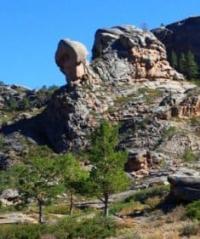
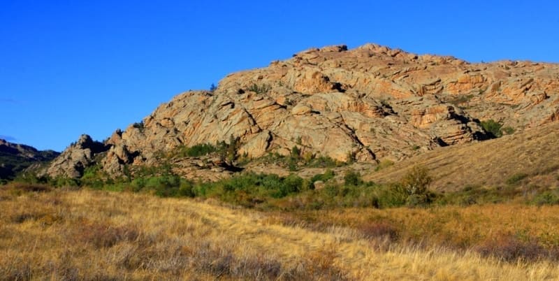
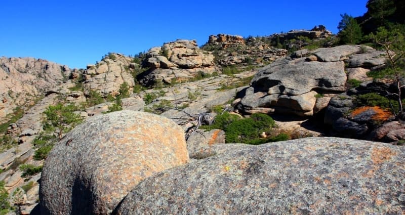
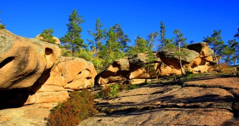
The elevation is characterized by a large number of hills and ridges, usually separated by closed depressions of various sizes and shapes. Hills have a dome-shaped or cone-shaped top, rising above the surrounding area to a height of several meters to 80 - 100 meters.
However, the relief of the small hill territory is complex, and it cannot be characterized only by a multitude of hills. In the middle, elevated part of the small hills there are mountains stretching from west to east - Ulytau (1137 meters above sea level), Karkaraly with the highest mountain Kyzyl-rai (1559 meters above sea level), Chingiz-Tau (1301 meters above sea level) .
In the northern part, on the border with the West Siberian Lowland, the Kokchetav Mountains are located separately, rising to almost 900 meters above sea level. In the eastern part, the Tarbagatai and Saur ridges rise above the Zaisan depression with peaks up to 3000 meters above sea level, bearing glaciers but not reaching the snow line.
On the watersheds there are flat areas composed of horizontally lying tertiary rocks. The central, elevated strip with mountains serves as a watershed between the depressions of the Aral Sea and Lake Balkhash in the south and the depression with Lake Tongiz and the Irtysh in the north.
From the hill, rivers flow in all directions to the south. Sarysu and the drying up northern tributaries of the lake. Balkhash, a number of rivers flow north to the Irtysh, and the Nura River flows into Lake Tengiz and does not go beyond the heights.
The rivers Ishim, Nura, Selety, Shiderty have permanent watercourses. Wide, dry, flat-bottomed valleys are a typical phenomenon for the entire strip of dry steppes and semi-deserts. They are also typical for small hills. In spring, they have temporary watercourses.
The length of these valleys reaches 700 kilometers, for example the Mointa valley is up to 15 kilometers wide. The completely flat, sometimes gravelly surface of the valley bottoms, overgrown with wormwood and solyanka, differs sharply from the surrounding small hills.
Clearly defined modern dry riverbeds up to 60 meters wide do not at all correspond to the large size of ancient relict valleys. In the strip of dry steppes and semi-deserts, erosion in the modern era occurs sporadically and does not have much significance in the formation of the modern topography of the upland.
Relict river valleys are modified and destroyed under the influence of physical weathering and aeolian processes. Erosion dissection is observed in valley strips. A large number of depressions contribute to the formation of temporary and permanent lakes.
There are a lot of lakes in the Kazakh small hills. Among them there are fresh, brackish and salty. The largest lakes of the elevation - Tengiz and Kurgaldzhin - are located at the bottom of the central depression and form a single lake-river system.
Most of the Kazakh hillocks are located in the semi-desert zone, and the northern, smaller part is in the steppe zone. The northern part of the Kazakh small hills, as well as almost the entire Turgai Plain, in its climate belongs to the West Siberian Plain.
The southern part of the small hills is characterized by great similarity with the climate of the Turan Lowland. The island mountains - Ulytau, Karkaraly, Chingiz-Tau and others - are distinguished by altitudinal climatic zonation.
Vegetation of Kazakh small hills.
The vegetation of the Kazakh small hills has a transitional character from steppe to desert. In the northern part of the small hills, in the Kokchetav region, steppes are widespread, in which turf grasses predominate. Fescue-fescue steppes; they are often disturbed, modified by dissected relief, mountains and bedrock outcrops.
In most of the small hills, fescue-wormwood semi-desert steppes are common. In their northern zone, cereals predominate, and in the southern zone, wormwood predominates. This general background of vegetation is often modified by meso- and microrelief, creating stripes and patches in the vegetation cover.
Thus, there are spots of different sizes of rocky semi-deserts, where (kara-jusan) predominates. Black wormwoods are confined to solonetzes. The stems of wormwood are up to 10 cm high; after rain, their leaves usually straighten; the root system is very powerful and reaches a depth of more than a meter.
White wormwood (ak-jusan) and other wormwoods occupy slightly saline areas. Wormwood steppes have their own special wormwood aroma associated with the essential oils contained in wormwood, especially black wormwood. Black wormwood is usually accompanied by (Anabasis sals), white winch - kokpek (Atriplex ana), (Kocia prostrata), camphorosma (Camphorosma monspeliacum), (Ceratocarpus arenarins), etc.
On salt marshes grow: saltworts, for example, (Halocnemum strobilaceum), (Statice suffruticosa), tamarisk, black wormwood. Among the turf grasses, the following are widespread: (Festuca sulcata, F. beckeri), (Koeleria gracilis), and feather grass. In spring, ephemerals develop rapidly - tulips (Tulipa biebersteiniana, T. schrenkii), (Rheum tataricum), camel grass (Ranunculus polyrhisus).
Altitudinal vegetation zones are formed on the mountains.
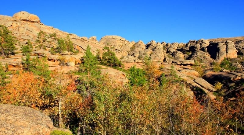
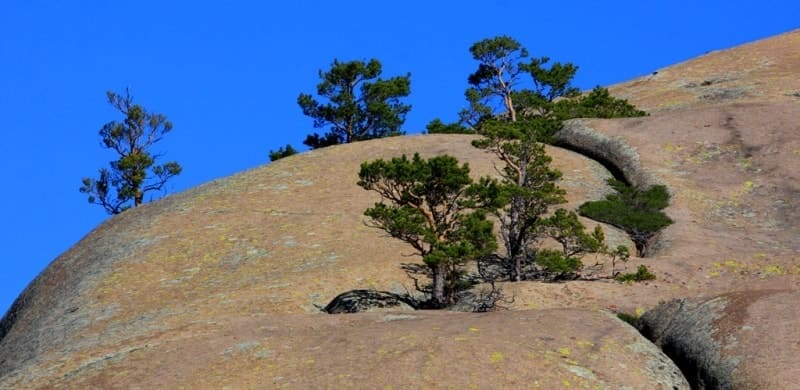
The entire elevated central strip of small hills with island mountains is occupied by feather grass-fescue, wormwood stony steppes, in which thickets of caragana shrubs (Tatagana tratex) and small birch groves are widespread. At the foot of the mountains, these steppes give way to wormwood-fescue rocky steppes.
Along the narrow, rather deep valleys cutting the lower parts of the slopes grow: birch, aspen, bird cherry, willow, hawthorn, and buckthorn. Pine forests grow on the mountains. In the northern part, pine-birch forests with aspen occupy the northern slopes of the hills. Pine on the sands extends to Semipalatinsk.
Fauna of Kazakh small hills.
Among forest animals we should name the common fox (Vulpes vulpes), wolf, teleut squirrel, badger (Meles meles), lynx; of birds - black grouse, gray and white partridge. Among the representatives of the steppes we will mention the yellow ground squirrel (Citellus fulvus), jerboa - large ground hare (Alactaga jaculus), small jerboa (Alactaga elater), brown hare (Lepus europneus), saiga (Saiga tatarica), ermine, weasel, steppe ferret, fox - corsac (Vulpes corsak), among birds - bustard (Otis tarda), kite (Milvus korschun), little bustard (Otis tetrax), steppe harrier (Circus marcourus), great black lark (Melanocorypha veltoniensis), little lark (Calandrella), white-winged lark (Melanocorypha leucoptera), horned lark (Eremophila alpestris brandti), saju, or hoofed lark (Syrrhaptes paradoxa), and among the sandgrouses - lapwing sandpiper (Vanellus gregarius).
On the lakes live: ducks, geese, seagulls, waders, swans. Among the reptiles, we will name the round-headed takyr lizard (Phrynocephalus helioscopus), the boa constrictor (Eryx miliaris), the copperhead snake (Ancistrodon halys caraganus), the fast foot-and-mouth disease (Eremias Velax), and the turtle (Testudo horsfieldi).
Mineral resources of Kazakh small hills.
Many iron deposits are known on the territory of the Kazakh hillocks; the largest of them are the Atasu and Karsakpaya deposits; there are deposits of manganese (Atasu, Dzhezdy - near Dzhezkazgan) and polymetals (Karagaily in the Karkaraly Mountains, Uspenskoye - east of Atasu, Maykain in the Ekibastuz region), gold and silver (Maykain); Between Karaganda and Balkhash large deposits of molybdenum, tungsten, copper, lead, zinc, and bauxite were discovered. The Karaganda coal basin with coking coals (geological reserves - 59 billion tons) serves as a fuel base for the metallurgy of Kazakhstan and the Urals.
The Ekibastuz coal basin has acquired great importance. Its deposits are distinguished by the significant thickness of the layers, which are developed by open-pit mining. On the basis of Karaganda coal and Atasu iron ores, the largest metallurgical plant, Kazakhstan Magnitogorsk, was built in Temirtau.
Large deposits of magnetite iron ores (Kacharskoye, Sokolovskoye, Sarbaiskoye, Kurzhunkolskoye) and phosphorous brown iron ores (Ayatskoye, Lisakovskoye), as well as bauxite (the largest is the Arkalykskoye deposit); Large coal
eserves were discovered (Ubagan basin).
The exceptional wealth and diversity of mineral resources in Central Kazakhstan contributed to the rapid growth of industry, which, however, was hampered by the lack of drinking and industrial water. The water supply problem was resolved by the creation of the Irtysh - Karaganda canal with a total length of 458 km.
Starting 30 km south of Pavlodar, it runs west through Ekibastuz to the Shiderty River, from where pumping stations supply water up the Shiderty River, through its watershed with the Nura into the Tuzda River valley, to Temirtau and Karaganda.
In the future, it is planned to supply water from here to Atasu and Dzhezkazgan. The canal provides guaranteed water supply to large industrial regions of Central Kazakhstan - Ekibastuz, Karaganda-Temirtau, and provides water for regular and estuary irrigation of lands, which allows increasing the production of vegetables, potatoes and animal feed.
The Nura-Ishim canal is also filled with Irtysh water. Groundwater will continue to play a major role in the water supply of Central Kazakhstan. In the steppe zone of Central Kazakhstan there are large tracts of fertile chernozem and dark chestnut soils.
Now high yields of grain crops are harvested here. Vast pastures of the semi-desert zone are the basis for the development of large sheep farms. Picturesque corners of nature in low mountain ranges, mineral springs and healing mud of lakes - all this makes it possible to create resorts here. The Borovoe resort in the vicinity of the Kokshetau mountains is widely known.
Geographic coordinates of Kazakh small hills: N49°17'22 E69°39'26
Authority:
N. A. Gvozdetsky, N. I. Mikhailov “Physical Geography of the USSR”, Asian part, Third edition, corrected and expanded, Moscow “Thought” 1978.
Photos by:
Alexander Petrov.