


![]()
Вы здесь
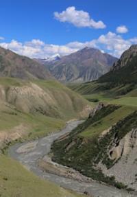
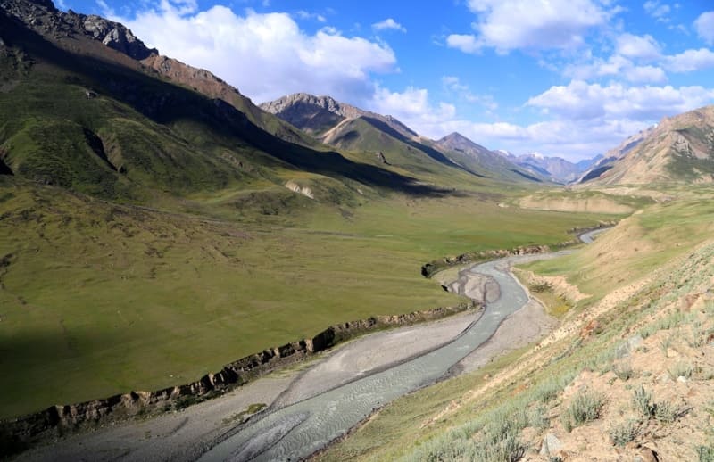
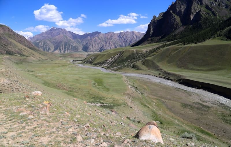
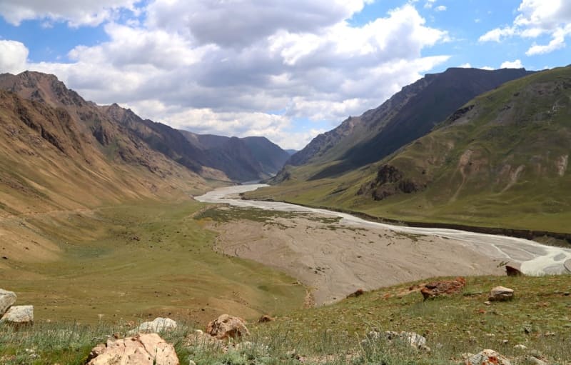
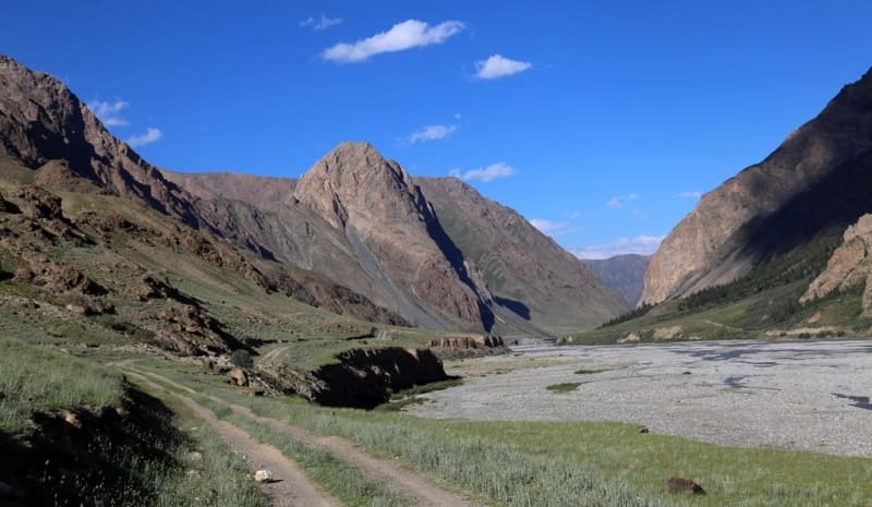
Kuilyu River.
Tourism in Issyk-Kul region.
“In the Vth century, as now, the sun rose every morning and every evening it went to bed. In the morning, when the first rays kissed the dew, the earth came to life, the air was filled with sounds of joy, delight and hope, and in the evening the same earth fell silent and sank into harsh darkness. Day was like day, night like night. Occasionally a cloud would roll in and thunder would roar angrily, or a gaping star would fall from the sky.”
A.P. Chekhov. "No title."
Rivers of Issyk-Kul region.
Kuylyu River is located at an altitude: source is 3164 and mouth is 2638 meters above sea level, it is located between northern slopes of Kuylyu ridge and southern slopes of Terskey Ala-Too ridge, in valley of same name in Ak-Suu district, in southeast of Issyk-Kul region.
89 kilometers from the beginning of the sources or 19.5 kilometers after the confluence of the Inylchek River on the left, a large tributary Kuilyu with a length of 39.7 kilometers flows into the Saryjaz River on the right. At an altitude of 3164 meters above sea level, at the confluence of the two rivers Karakol-Tor and Ashutor, the Kuylyu River is formed. The mouth of the river is located at an altitude of 2638 meters above sea level.
Geographic coordinates of Kuylyu River: N42°11'55 E78°55'11
Sources of Kuilyu River.
Karakol-Tor River.
Karakol-Tor River, 11.6 kilometers long, is a southern tributary of the Kuilyu. At an altitude of 3164 meters above sea level, the river merges with the Ashu-Tor River to give rise to Kuil. The river's sources begin with three glaciers: Karakol-Tor East, Karakol-Tor South-East and Karakol-Tor South-West.
Glacier Karakol-Tor Eastern.
The area of the glacier is 13.41 square kilometers, the perimeter of the glacier reaches 27.91 kilometers. The length of the glacier is 6 kilometers. The upper boundary of the glacier is located at an altitude of 4610, 4709, 4620, 4726 (Slonenok Peak), 5020 (Dzhigit Peak) meters above sea level.
Geographic coordinates of Karakol-Tor Eastern glacier: N42°09'58 E78°32'32
Glacier Karakol-Tor South-East.
The area of the glacier is 5.49 square kilometers, the perimeter of the glacier reaches 13.27 kilometers. The length of the glacier is 5.6 kilometers. The upper boundary of the glacier is located at an altitude of 4523.7 and 4721.3 meters above sea level.
Geographic coordinates of Karakol-Tor South-Eastern glacier: N42°13'07 E78°36'18
Glacier Karakol-Tor South-West.
The area of the glacier is 7.05 square kilometers, the perimeter of the glacier reaches 18.64 kilometers. The length of the glacier is 5.5 kilometers. The upper boundary of the glacier is located at an altitude of 4721.3 meters above sea level.
Geographic coordinates of Karakol-Tor South-West glacier: N42°12'52 E78°37'20
Geographic coordinates of Karakol-Tor River: N42°08'56 E78°40'08
River Ashu-Tor.
The Ashu-Tor River, 11.9 kilometers long, is an eastern tributary of the Kuilyu. At an altitude of 3164 meters above sea level, the river merges with the Karakol-Tor River to give rise to the Kuil. The sources of the river begin with two glaciers: Ashu-Tor Left and Ashu-Tor Right. In the eastern part of the glacier, in the watershed ridge, there is the Kuilyu Pass, 4303 meters above sea level.
Glacier Ashu-Tor Left.
The area of the glacier is 1.07 square kilometers, the perimeter of the glacier reaches 5.63 kilometers. The length of the glacier is 2.3 kilometers. The upper boundary of the glacier is located at an altitude of 4604 meters above sea level.
Geographic coordinates of Ashu-Tor Left glacier: N42°03'51 E78°36'25
Glacier Ashu-Tor Right.
The area of the glacier is 5.18 square kilometers, the perimeter of the glacier reaches 13.45 kilometers. The length of the glacier is 5.07 kilometers. The upper boundary of the glacier is located at an altitude of 4636 meters above sea level.
Geographic coordinates of Ashu-Tor Right glacier: N42°03'17 E78°37'23
After 7.3 kilometers from the beginning of its sources, the Ashu-Tor South tributary, 6.8 kilometers long, adjoins the Ashu-Tor River on the left. The sources of the tributary begin from the Ashu-Tor South-Eastern glacier. The area of the glacier is 5.65 square kilometers, the perimeter of the glacier reaches 18.75 kilometers. The length of the glacier is 3.27 kilometers. The upper boundary of the glacier is located at an altitude of 4455 meters above sea level. In the upper reaches, in the northern part of the river, there are 3 small, moraine lakes.
Geographic coordinates of Ashu-Tor South-Eastern glacier: N42°08'02 E78°35'14
Geographic coordinates of Ashu-Tor River: N42°06'00 E78°38'27
Right tributary of Kuylyu River.
Kara-Tor River.
After 834 meters from the beginning of its sources, the 6.7-kilometer-long tributary Karator flows into the Kuilya River on the right. In the upper reaches the river receives its sources from the Kara-Tor glacier. The mouth of the river is located at an altitude of 3145 meters above sea level.
The area of the Kara-Tor glacier is 9.25 square kilometers, the perimeter of the glacier reaches 27.74 kilometers. The length of the glacier is 5.52 kilometers, the glacier is located on the northern slope of the Kuilyu ridge. The upper boundary of the glacier is located at an altitude of 5203.2 (Obruchev Peak) meters above sea level.
Geographic coordinates of Kara-Tor glacier: N42°02'35 E78°41'59
Geographic coordinates of Kara-Tor River: N42°05'46 E78°42'30
Mana-Syntash River.
After 1.9 kilometers from the beginning of its sources, the Mana-Syntash tributary, 4 kilometers long, flows into the Kuilya River on the right. The river is located on the northern slope of the Kuilyu ridge in the gorge of the same name. Mana-Syntash glacier.
The area of the glacier is 2.56 square kilometers, the perimeter of the glacier reaches 7.27 kilometers. The length of the glacier is 3.4 kilometers. The upper boundary of the glacier is located at an altitude of 4745 meters above sea level.
Geographic coordinates of Mana-Syntash glacier: N42°05'05 E78°44'10
Geographic coordinates of Mana-Syntash River: N42°06'35 E78°44'02
River Bordu Tor.
5.7 kilometers from the beginning of the source after the beginning of the Kuylyu River, a 7.8-kilometer long tributary Bordu-Tor flows into the Kuylyu River on the right. In the upper reaches, at an altitude of 3268 meters above sea level, the river forms the main channel of two tributaries.
The river receives its sources from three Bordu Tor glaciers: Eastern, Central and Western, located on the northern slope of the Kuilyu ridge, in the gorge of the same name. The river receives its main source from the Bordu-Tor Central glacier.
After 3.4 kilometers, a tributary adjoins on the left, which flows from the Bordu-Tor East glacier with a length of 1.7 kilometers. After 5.5 kilometers, a tributary flows into the right, which originates from the Bordu-Tor West glacier with a length of 3.7 kilometers.
Glacier Bordu-Tor East.
The area of the glacier is 1.59 square kilometers, the perimeter of the glacier reaches 4.87 kilometers. The length of the glacier is 1.75 kilometers. The upper boundary of the glacier is located at an altitude of 4745 meters above sea level.
Geographic coordinates of Bordu Tor East glacier: N42°05'19 E78°45'18
Bordu-Tor Central glacier.
The area of the glacier is 4.88 square kilometers, the perimeter of the glacier reaches 12.87 kilometers. The length of the glacier is 3.73 kilometers. The upper boundary of the glacier is located at an altitude of 5402 meters above sea level.
Geographic coordinates of Bordu Tor Central glacier: N42°03'43 E78°45'59
Glacier Bordu-Tor Western.
The area of the glacier is 4.47 square kilometers, the perimeter of the glacier reaches 11.04 kilometers. The length of the glacier is 4.29 kilometers. The upper boundary of the glacier is located at altitudes of 5020 and 4870 meters above sea level.
Geographic coordinates of Bordu Tor Western glacier: N42°04'48 E78°48'35
Geographic coordinates of Bordu Tor River: N42°06'44 E78°46'28
Kara-Su River.
After 8.7 kilometers from the beginning of the sources, the Kara-Su tributary, 4.6 kilometers long, flows into Kuilya on the right. The river is located on the northern slope of the Kuilyu ridge in the gorge of the same name. The river receives its source from the Kara-Su glacier.
Glacier Kara-Su. The area of the glacier is 1.59 square kilometers, the perimeter of the glacier reaches 6.51 kilometers. The length of the glacier is 3 kilometers. The upper boundary of the glacier is located at an altitude of 4591 meters above sea level.
Geographic coordinates of Kara-Su glacier: N42°06'36 E78°49'38
Geographic coordinates of Kara-Su River: N42°08'03 E78°48'25
Oroi-Su River.
After 13.6 kilometers from the beginning of its sources, the Oroi-Su tributary, 8.1 kilometers long, flows into the Kuilyu River on the right. In the upper reaches of the river, on the northern slope of the Kuylyu ridge, in the gorge of the same name, there are three Oroi-Su glaciers: Eastern, Central and Western. Glacier Oroi-Su Eastern.
The area of the glacier is 1.47 square kilometers, the perimeter of the glacier reaches 5.99 kilometers. The length of the glacier is 2.48 kilometers. The upper boundary of the glacier is located at an altitude of 4704 meters above sea level. The end of the glacier is located at an altitude of 3960 meters above sea level.
Geographic coordinates of Oroi-Su Eastern glacier: N42°06'05 E78°50'36
Glacier Oroi-Su Central. The area of the glacier is 3.39 square kilometers, the perimeter of the glacier reaches 10.54 kilometers. The length of the glacier is 3.76 kilometers. The upper boundary of the glacier is located at an altitude of 4571 meters above sea level. The end of the glacier is located at an altitude of 3805 meters above sea level.
Geographic coordinates of Oroi-Su Central glacier: N42°05'57 E78°51'33
Glacier Oroi-Su Western.
The area of the glacier is 2 square kilometers, the perimeter of the glacier reaches 7.09 kilometers. The length of the glacier is 3.13 kilometers. The upper boundary of the glacier is located at altitudes of 4750 meters above sea level. The end of the glacier is located at an altitude of 3891 meters above sea level.
Geographic coordinates of Oroi-Su Western glacier: N42°04'48 E78°48'35
Geographic coordinates of Oroi-Su River: N42°08'20 E78°51'30
Kindyk River.
After 18.5 kilometers from the beginning of the source, at an altitude of 2848 meters above sea level, the 8.4-kilometer-long tributary Kindyk flows into the Kuilya River from the right. In the upper reaches of the river, at the source on the northern slope of the Kuilyu ridge, in the gorge of the same name, there are two Kindyk glaciers: Kindyk and Kindyk East.
Kindyk Glacier.
The area of the glacier is 4.37 square kilometers, the perimeter of the glacier reaches 10.85 kilometers. The length of the glacier is 3.49 kilometers. The upper boundary of the glacier is located at an altitude of 4639 meters above sea level. The end of the glacier is located at an altitude of 3842 meters above sea level.
Geographic coordinates of Kindyk glacier: N42°06'37 E78°53'40
Glacier Kindyk East.
The area of the glacier is 1.91 square kilometers, the perimeter of the glacier reaches 5.89 kilometers. The length of the glacier is 2.45 kilometers. The upper boundary of the glacier is located at an altitude of 4443 meters above sea level. The end of the glacier is located at an altitude of 3924 meters above sea level.
Geographic coordinates of Kindyk Vostochny glacier: N42°07'28 E78°55'09
Geographic coordinates of Kindyk River: N42°09'06 E78°53'53
Big Sary-Bulak River.
After 25.3 kilometers from the beginning of the source, at an altitude of 2848 meters above sea level, a tributary of 6.9 kilometers long flows into the Kuilya River from the right.In the upper reaches of the river, at the source on the northern slope of the Kuilyu ridge, in the gorge of the same name, there are two Kindyk glaciers: Kindyk and Kindyk East.
Glacier Big Sary-Bulak. The area of the glacier is 3.85 square kilometers, the perimeter of the glacier reaches 14.58 kilometers. The length of the glacier is 5.21 kilometers. The upper boundary of the glacier is located at an altitude of 4467 meters above sea level. The end of the glacier is located at an altitude of 3637 meters above sea level.
Geographic coordinates of Big Sary-Bulak glacier: N42°08'01 E78°57'06
Geographic coordinates of Bolshoi Sary-Bulak River: N42°11'03 E78°57'58
Left tributaries of Kuylyu River.
Sarychat River.
After 14.7 kilometers from the beginning of its sources, the Sarychat tributary, 15.9 kilometers long, flows into the Kuilya River on the left. In the upper reaches of the river, at the source on the northern slope of the Kuilyu ridge, in the gorge of the same name, there is a large, main glacier, Sarychat.
Big Sarychat glacier. The area of the glacier is 5.53 square kilometers, the perimeter of the glacier reaches 15.03 kilometers. The length of the glacier is 4.45 kilometers. The upper boundary of the glacier is located at an altitude of 4528 meters above sea level. The end of the glacier is located at an altitude of 3707 meters above sea level.
Geographic coordinates of glacier Sarychat: N42°13'47 E78°40'12
Geographic coordinates of Sarychat River: N42°11'54 E78°47'43
Sharkyratma River.
After 19.2 kilometers from the beginning of the sources, at an altitude of 2848 meters above sea level, the Sharkyratma tributary, 10.2 kilometers long, flows into the Kuilya River from the left. The main channel of the river from two tributaries is formed at an altitude of 3359 meters. The sources of the river are located at an altitude of 4531 meters above sea level. On the river, 440 meters before the mouth, there is a waterfall of the same name at an altitude of 2962 meters above sea level.
Geographic coordinates of Sharkyratma River: N42°13'04 E78°51'56
Mola River.
After 24.2 kilometers from the beginning of the sources, at an altitude of 2848 meters above sea level, the Mola tributary, 13 kilometers long, flows into the Kuilya River on the left. The river is located on the southern slope of the Terskey Ala-Too ridge.
In the upper reaches of the river there are 6 small glaciers located on the eastern slope of the Mola gorge. The upper limit of the glaciers is located at an altitude of 4663 and 4602 meters above sea level. The mouth of the river is located at an altitude of 2816 meters above sea level.
Geographic coordinates of Mola River: N42°14'15 E78°55'04
Authority and photos by:
Alexander Petrov.