


![]()
Вы здесь
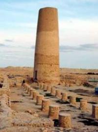
Cathedral mosque Mashad ata.
Tours on medieval town of Messerian.
"...greatness of the world and belief, protection of Islam and devout, God's shadow in the worlds, the sultan Muhammad, the son of the sultan Tekesh..."
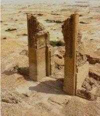
Portal inscription fragments.
Trade and craft centers of Turkmenistan.
The ruins of the cathedral mosque in the medieval city of Messerian is located at an altitude of 159 meters above sea level, located in the northern part of the Messerian plain and in the southern part of the Choganli plain, in the northwestern part of the Khurmen sands, 17.7 kilometers northwest of the village of Madau. 42.9 kilometers north-east of the small village of Indyrlan in the Etrek etrap of the Balkan velayat.
Mashad-ata is the oldest preserved mosque on the territory of Turkmenistan. In the anonymous work of the 10th century "Khudud-al-Alem" there is information about the burial of the Sufi sheikh Ali al-Sukkari near Dehistan.
There is also valuable evidence in the work of al-Maqdisi, an Arab geographer who lived in the 9th century. In his book, which contains a wide variety of information about many countries of the East, there is information about Dehistan.
The only monument of this historical period is the remains of the cathedral mosque. Preserved two pylons of the portal of the main premises of the mosque and the minaret, which now rises to a height of 20 meters. The mosque had a rectangular courtyard with a pool, surrounded by a vaulted gallery, over which an 18-meter portal towered.
In the main building of the mosque, from which two pylons remain, there is a square hall with a domed roof. The minaret, like the foundations of the portal, is made of fired bricks on alabaster mortar. Damaged, it still retained a significant part of the conical surface, laid out in paired spoons in a checkerboard pattern.
The photographs from the late 19th century still show the upper part of the minaret with brick ornaments and a Kufic inscription. The abutments of the portal, carefully laid out with paired bricks, make it possible to recreate the overall dimensions of the structure with a pointed high arch on three-quarter columns with figured gimbals.
Fragments of the portal inscription, read by A.A. Semenov and M.E. Masson, give important information about the time of construction and names. Following the Koranic text, the inscription says: "... the greatness of the world and faith, the protection of Islam and the faithful, the shadow of God in the worlds, Sultan Muhammad, the son of Sultan Tekesh...".
In addition to the ruler of Khorezm, Sultan Muhammad (1200 - 1220), the names of the builders of the mosque and the minaret - Abu-l-Hussein ibn Muhammad an-Nak and Muhammad ibn al-Hussein an-Nak were named.
Obviously, all the other buildings of the pre-Mongol Mestoriana were subsequently destroyed by pogroms. He calls the city center of Dehistan Rabat. Ar-Rabat is a word of Arabic origin which means a walled city. Along with words of praise about the cleanliness of this city, about its beautiful mosques, comfortable dwellings, well-maintained streets, he also reports about the old mosque, which was located below Ar-Rabat in a place similar to Dandanakan (a medieval town in the Merv district).
From the story of al-Maqdisi, one can also learn that in his time the building was surrounded on four sides by an arched-ayvan ceiling resting on wooden pillars. The mosque was famous not only in Dehistan, but also in neighboring regions.
And in the middle of this place (between Misrian and Mashad-ata) there was another mosque with a minaret. The latter is probably just the Shir-Kabir mosque. It is worth mentioning the truly sensational archaeological discoveries made during the implementation of this project.
For two seasons - last spring and autumn - in front of the main facade of the mosque, an experienced archaeologist Davron Abdulloev, invited from St. Petersburg, excavated the foundations of an arcade that once existed here, facing the courtyard, which was surrounded by residential buildings.
It became clear that the mosque was one with the khanaka - a Sufi abode, or a hospitable home. Numerous cells were discovered, in which the hermits-monks lived, they conducted their modest households here.
The northeastern corner of the khanaka was closed by the minaret - no one even suspected its existence here! Now scientists have a relatively complete picture of the centuries-old life of this religious complex, in the architecture of which various eras of Islamic art are reflected.
Geographic coordinates of the cathedral mosque in the medieval town of Messerian: N38 ° 15'58.64 "E54 ° 37'18.18"
Authority:
On materials of information department of the State committee of Turkmenistan on tourism and sport. "Religious and spiritual monuments to Central Asia". Author M. Hashimov. Saga publishing house, 2001.