


![]()
Вы здесь
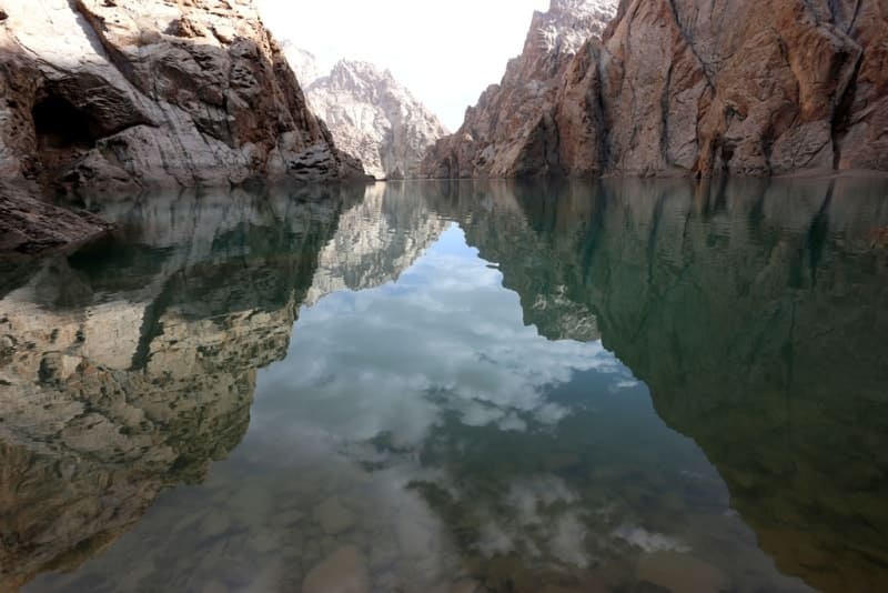
Lake Kel-Suu.
 - Russian botanist, horticultural scientist, local historian, archaeologist, teacher, winegrower, hop grower, cheese maker, livestock breeder. “Excursion to Zanaryn Mountains in 1879.”")

Travel on lakes Naryn of province.
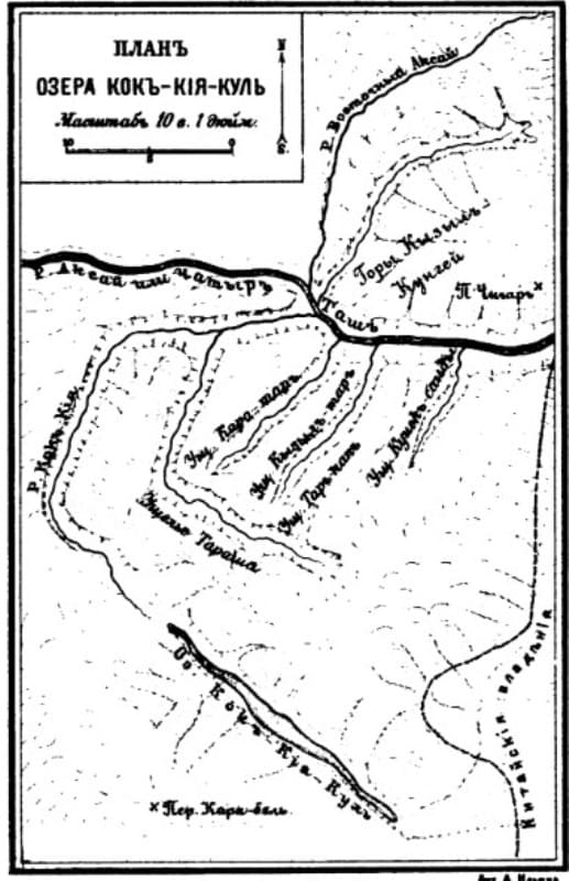
"The Kok-Kiya River flows out about thirty-five versts from its mouth from a high mountain lake, which, judging by the fall of the river, must be considered to be 12,500 feet or rather 11,000 feet above sea level. However, according to the Kirghiz, this lake is freed from ice in the summer, therefore, it is still considerably lower than the eternal snow, which confirms my calculation presented above of no less than 14,000 feet for the eternal snow at the lake and somewhat lower to the mouth of the Kok-Kiya River, but since the peaks turn their mountain slopes towards the lake, the eternal snow here can rise even higher. Having left the lake, the river immediately enters a crack between the two highest peaks of the range, and flows along this crack to Aksai itself."
"Travel through the Turkestan region and exploration of the mountainous country of Tien-Shan." N. Severtsov. 1873.
"I confess that this lake interested me, not so much because of its severe appearance among the overhanging cliffs, but because of its mystery. Besides, the insignificant open space, so to speak - those gates through which we penetrated, it was impossible to take a step along the shore of the lake: there was absolutely no shore here, except for the overhanging vertical cliffs, and therefore there was no way to examine the lake. This examination could have been done only in a boat. It turned out that no river flowed out of the lake, and the river that I saw from afar flowed not out of the lake, but directly from under the ground, cutting, apparently, that moraine-shaped rampart that separates the lake from the valley."
"Across the mountainous regions of Russian Turkestan." V. I. Lipsky. 1906.
Mountain hiking in Kyrgyzstan.
Flowing, freshwater lake Kel-Suu is located at an altitude of 3514 meters above sea level, is located to southeast and east of Sarybeles Mountains, to west and southwest of Keltau Mountains, on northern slope of western part of Kokshaal-Too ridge in Atbashi district, in southeast of Naryn region.
An almost meridional lake of the dammed type, formed from a strong earthquake, during the collapse of a mountain range. The length of the lake from the south-east to the north-west is 12 kilometers, taking into account the bends of the canyon.
From the south, the Korumduk River, 33 kilometers long, flows into the lake. After the confluence of the Korumduk River, after 2.8 kilometers, the lake expands to 907 meters. This is the widest spot in the southern part of the lake.
Most of the lake is a winding canyon. The Korumduk River in the southern part of the lake spreads out with a delta 645 meters wide.
Geographic coordinates of northern border of Lake Kel-Suu: N40 ° 42'07 "E76 ° 23'23
Geographic coordinates of southern border of Lake Kel-Suu: N40 ° 36'45 "E76 ° 24'48
The area of the lake is 4.5 square kilometers, the volume of water is 338 million cubic meters, the depth of the lake is up to 10 meters. The water level in the lake changes annually, up to shallowing. 4 rivers flow into the lake from the western slope of the Sarybeles mountains, the main of them (from south to north): Koshdzhaylo river with a length of 7 kilometers. Koshjailoo has one tributary on the left - Koshjailo Severnaya, 5 kilometers long.
The next flows into the river Karabel Western with a length of 5.5 kilometers. This is followed by two unnamed tributaries, one of which is 2.3 kilometers long. 5 rivers flow into the lake from the eastern slope of the Kel-tau ridge, the main of them (from south to north): Eshimart, 6 kilometers long, in turn, Eshimart has a tributary from the left, Ekayryk, 7 kilometers long.
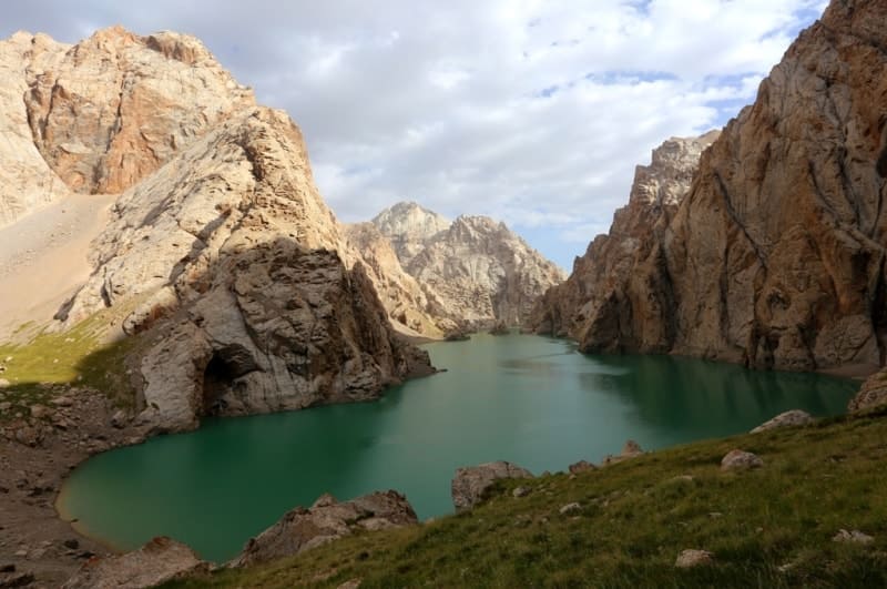
The next river is Echkilidzhilga with a length of 5.5 kilometers and Ulusbol with a length of 3.4 kilometers. Behind them is a small unnamed tributary 2.8 kilometers long. Lake Kel-Suu is one of the most beautiful alpine lakes in Kyrgyzstan.
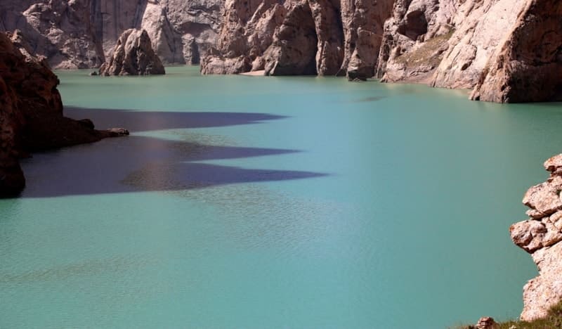
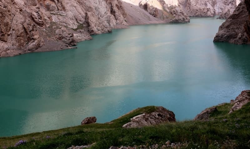
The dam offers a beautiful view of the lake with its fantastic views - sheer cliffs hundreds of meters high, waterfalls, a rocky island, bays, caves and grottoes. The turquoise bowl of water is surrounded by steep peaks, the tops of which are covered with snow even in the hottest summer.
History of study of Lake Kel-Suu.
For the first time, Lake Kel-Suu was visited on August 28, 1879 by Alexey Mikhailovich Fetisov (1842 – 1894) – Russian botanist, gardener, local historian, archaeologist, teacher, winegrower, hop grower, cheese maker, livestock breeder. In his two works, one of which was “Excursion to the Trans-Naryn Mountains in 1879.”, his work was published in the “Turkestan News” in 1881, in issues 35, 37, 38, 39,45, 46,51.
The traveler talks about the lake and a trip to the Sarybeles and Kel-Tau mountains. In these articles, A. Fetisov calls the lake Yashil-kul or Lake Kulduk.
Since 1878, A.M. Fetisov worked as a city gardener in the city of Pishpek.
In 1902, the lake was visited by the head of the Atbashinsky section, Pavel Pavlovich Ivanov.
In July 1903, the northern part of the lake was visited by Vladimir Ippolitovich Lipsky, who prepared a detailed description of the northern part of the lake in the work "Along the mountainous regions of Russian Turkestan" published in 1906.
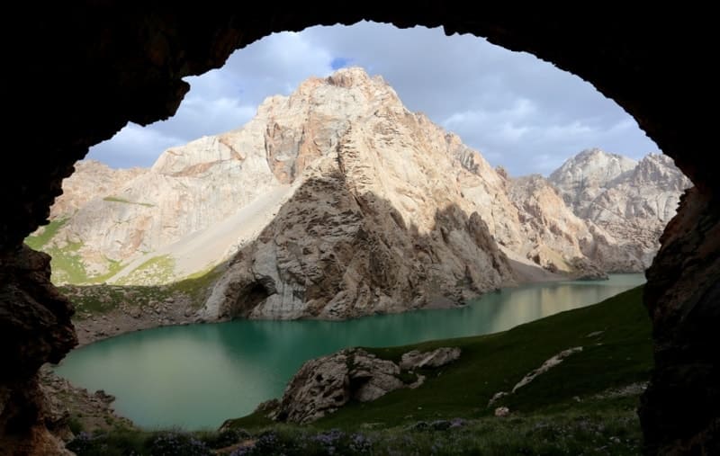
The color of the water changes constantly, depending on the lighting. Approximately two kilometers from the dam, between the sheer walls of the canyon, one can see a rock-island fifty meters high. The rocks have a bizarre relief - they are dotted with grottoes, caves and depressions.
To see the lake in full and to enjoy, you need to sail on it in boats. The caves are also very interesting. The main cave has a narrow entrance hidden in the rocks on the right side of the dam. First, you find yourself in a large high hall with an "altar", and then the cave descends and divides into two narrow passages.
There are no stalactites, although the walls of the lower corridors are covered with an interesting texture, similar to coral reefs, which are adorned with water crystals. Even in summer it is very cold there. Fantastic and unforgettable. The name of the lake is translated as “incoming water” and for good reason, because the lake tends to disappear and then fill up again.
At the entrance to the lake, the area is rather swampy. I visited the lake in July 2015 and 2022, the lake landscapes were enchanting.
Geographic coordinates of Lake Kel-Suu: N40 ° 39'04 "E76 ° 23'38
Authority and photos by::
Alexander Petrov.
www.dive.kg
www.kyrgyzstantravel.info