Вы здесь
Turgai Geoglyph in Kazakhstan.
Tours on Geoglyph Kazakhstan.
“Why do you go away? So that you can come back. So that you can see the place you came from with new eyes and extra colors. And the people there see you differently, too. Coming back to where you started is not the same as never leaving”
Terry Pratchett. “A Hat Full of Sky”.
Wildlife Tours in Kazakhstan.
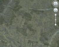
Geoglyphs are the most unusual and one of unique monuments in Kostanay region. We must mass development of new technologies for opening this monument. The enthusiast Dmitry Dey noticed unusual and visible images in the form of geometric shapes and patterns on the surface of the earth when he was considering satellite images of Google Earth in 2007.
Further study has shown that we are dealing with one of the most mysterious ancient structures - Geoglyphs. Geoglyphs are geometric or shaped patterns, which inflict to the ground with a length of more than 4 meters. Many geoglyphs are so large, that it can be seen only from the air (the most famous example - the Nazca geoglyphs).
There are several ways of creating geoglyphs: by removing the top layer of the soil around the perimeter of the pattern, by sprinkling of rubble where the line should pass pattern, by planting trees, by forming the desired patterns.
Geoglyphs are used for artistic purposes in these days. There is a fact about the uniqueness of Turgai geoglyphs - such objects are found nowhere in the world. There are vaguely reminiscent of geoglyphs in Minusinsk Basin, in Khakassia (there are very little and primitive in comparison with ours) and Peru (Chankilo city), but the South American objects were built of stones.
According to results of numerous expeditions of Turgai objects by Dmitry Dey together with Kostanay archaeologists there was a discovery of dozens of geometric shapes, including Ushtogay square, Turgai swastikas, Ekidin cross, Aschytastyn crosses, square, ring and two lines.
Objects were constructed from mounds. Today more than 50 objects are opened, and they are all located in one place - in Turgai trough. Foreign scientists investigated Geoglyphs too. Motuzayte Giedre, a scientist from Oxford (UK), visited Turgai Geoglyphs in the summer of 2013.
She took soil samples from the mound, which was best-preserved Geoglyph in order to establish their date. British scientists found out that "the youngest" Turgai Geoglyph was constructed between the first century BC and the first century AD.
It means that they are 2,5 thousand years. Meanwhile, ancient Torgai geoglyphs, which can be viewed only from space, can be aged between 7000 years of age and older. Geoglyphs remain a mystery to scientists and archaeologists. However, some of the mysteries have disclosed.
Logvin Victor, head of the laboratory of archaeological research KSU. A.Baitursynov said about this unique facility: "After analyzing the Turgai geoglyphs, we can draw the following conclusions about these monuments; apparently, it had a sacred, religious purpose, and were built for the cult-funeral rites, and could also serve as symbols of belongings to a specific territory family, tribe or tribal association. It might be left by native Hun-Sarmatian culture".
According to many scientists, the discovery of Turgai geoglyphs is completely new, not only in Kazakhstan archeology, but also has a great global importance. It is important not to destroy these objects with traditional methods of management, and save for tourists.
According to the academician of the International Academy of Tourism and Sports - Sapar Iskakov, uniqueness of Turgai geoglyphs can be revealed as an object, which will develop the tourism in Kazakhstan to the highest level, in particular in the Kostanay region.
Geoglyph "Big Ashtytasty cross” in the interfluve of Ashtytasty, which is 3.6 kilometers to the east, drying up Zhusalysai, which is 8.5 kilometers to the north and drying up Zhosaly, which is 10.5 kilometers to the east being the right tributary of the river Ashtytasty.
The village of Koktau is 18 kilometers to the east and the city of Arkalyk is 51 kilometers to the east. The geoglyph is located on the territory of the city administration of Arkalyk, Kostanay region. The “Great Ashtyasty Cross” is equally oriented to the cardinal points.
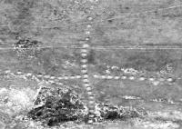
84 meters north of the northern part of the cross there is a rampart in the western part and three burial mounds to the east of it. The large "Ashtyasty cross" is a cruciform figure, which consists of 38 embankments. The figure is 436 meters long.
The geoglyph "Turgai swastika" is located in the eastern part of the Turgai hollow, on the right bank of the Kara-Torgai river in the Amangeldy district of the Kostanay region, at an altitude of 145 meters above sea level. From the village of Amangeldy to the geoglyph - 19 kilometers.
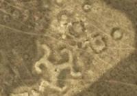
"Turgai Swastika" is located on the north-western shore of Lake Agashtykol, 411 meters and 542 meters from the village of Agashtykol to the south-east. The geoglyph is a mound in the form of a three-beam swastika. Each of the rays ends in a zigzag shape, the ends of which are bent counterclockwise.
The height of the embankment is up to 0.3 meters, the length of the beam is about 33 meters, the width at the base is 13 - 15 meters, and the width at the end is 10 - 12 meters. Zigzag shapes 40-50 meters long, 5-6 meters wide, curved parts 15 - 20 meters long. In the center of the structure there is a depression with a diameter of 4 meters and a depth of up to 0.3 meters.
The swastika fits into a circle with a diameter of about 90 meters. Near the structure there are small embankments with a diameter of 10 - 15 meters, a height of 0.2 - 0.3 meters, surrounded by a moat.
No earthworks were carried out at the facility, so as not to subject it to destruction.
It is possible to date this structure according to the available features in a wide range from the Bronze Age to the Middle Ages.
The geoglyph "Turgay ring" or "Ashtysty ring" is located in the interfluve of three rivers, Ashtytasty, which is located 1.8 kilometers in the south, the drying channel of the Zhusalysay, 15 kilometers to the southeast and the channel of the Tasty river, flowing at 13.6 kilometers in the north-west, which is the right tributary of the Ashchytasta River.
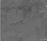
16.5 kilometers in the north-west, there is the village of Tasty, 56 kilometers in the south-east is the town of Arkalyk. Geoglyph is located on the territory of the town administration of Arkalyk, Kostanay region. The geoglyph "Turgai Ring" is a circle that consists of 25 embankments, 170 meters in diameter.
There are three ring ditches to the north of the Turgai Ring. A group of several burial mounds is located 1.2 km east of the Turgai Ring geoglyph, and three burial mounds are located 220 meters to the southwest. In 5, 2 kilometers to the northwest there is a group of 4 kurgans stretched in a line from the southwest to the northeast.
Geoglyph "Ashtysty cross" is located 19 kilometers south-east of the geoglyph "Turgai ring". Geographic coordinates of the geoglyph "Turgai Ashytasty ring" - N50 ° 22'05.82 "E66 ° 09'00.56"
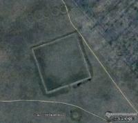
The geoglyph "Ushtogay square" is located in the eastern part of the Kostanay region, in the northeast of the Amangeldy region, 163 kilometers northwest of the city of Arkalyk. The geoglyph "Ushtogay square" is located in the southwestern part of the Saryadyr mountain range, which stretches in the latitudinal direction for 84 kilometers and has a maximum elevation of 290 meters above sea level.
In the southern part of the hilly Karakuduk mountains, which belong to Saryadyr, with an elevation of 197 meters above sea level, stretching from south-west to north-east for 9 kilometers and is the "Ushtogay square". From the village of Ushtogay to the geoglyph 15 kilometers.
"Ushtogay square" - is a geometric figure - a square with diagonals, presented out of 101 mounds in the form of mounds, approximately the same size. Burial mounds with a diameter of 11 to 15 meters, a height of about 1 meter.
The length of the eastern side of the square is 279 meters, the length of the western side of the square is 272.5 meters. The square is oriented diagonally to the cardinal points. Approximately at a distance of 112 meters from the northwest corner, three rings, each 19 meters in diameter, are located diagonally
Geoglyph "Shiiliysky square" is located in the eastern part of the Zhylanshykturme upland. In the interfluve of the Kara-Torgai, which is 7 kilometers south, the drying up Taldysai, which is 3.5 kilometers to the west, and the drying up Shilisay, which is 6 km to the east, flowing through the village of Kayindy.
The village of Kayindy is 7 kilometers to the east and the town of Arkalyk is 78 kilometers to the north-east. The geoglyph is located on the territory of the city administration of Arkalyk, Kostanay region. "Shilii square" is a square area surrounded by a rampart and a moat located on the outside.
The side of the square is about 225 meters long. The width of the shaft is 10 - 12 meters, the height is 1 - 1.5 meters, the width of the ditch is 10 - 12 meters, the depth is up to 1 meter. In the southern part, there is an entrance to the structure, represented by a rupture of a rampart and a ditch.
A hundred meters to the south of the square there is a mound with a flat top, the embankment was built of earth, the embankment diameter is 30 meters, the height is 1.5 meters, it is ringed with a moat up to 10 meters wide and up to 0.8 meters deep.
One hundred meters to the north of the square, there are five circles, which are platforms ringed with a shaft and lined up parallel to the side of the square. The diameter of the circle is 30 - 35 meters, the width of the shaft is 4 - 5 meters, the height is 0.2 - 0.3 meters.
Authority:
http://culturemap.kz and Alexander Petrov.


