


![]()
Вы здесь
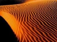
Balkhash sands of Sary-Ishik Otrau.

Sights of Saryesik sands of Atyrau.
"Closer to the edge of the Balkhash reeds, sand hills are found among the steppe. After walking about eight miles from the village, we approached the reeds, a wide strip bordering the southern shore of Lake Balkhash to the Chit-Bakanas ravine. From the top of a sand hill, a verdant sea of greenery appears before the observer."
A. M. Nikolsky. "Journey to Lake Balkhash and the Semirechye Region." 1885.
Flora of Saryesik sands of Atyrau.
Framed by the riparian fringe of Lake Balkhash and treeless mountainous uplands, pressed to the east by the Karatal River and to the west by the Ili River valley, stretches a continuous expanse of sand. This is one of the most significant sand deserts in Kazakhstan.
It stretches for 230 km meridionally and 184 km parallel to the north. Its area is approximately 35,000 square kilometers. In the southern part, they are known as Kzyl-jingil, Muyun-kum, Jenishke-kum, and others, while in the northern part, they are united under the common name of Sary Ishik-otrau.
All these sands were formed by the dispersal of lake and river sediments, and partly by the smallest particles of eroding mountains nearby. They are cut both lengthwise and crosswise by caravan tracks. From the banks of the Ili River, the sands begin as isolated mounds amid empty, level clearings.
Then the isolated mounds become gentle ridges, and further away, steep ones. The closer they get to the center, the denser and more massive the sand ridges become. They cover the entire visible area in monotonous, winding ramparts up to 10-12 meters high or more.
Chains of sand ridges and mounds, covered with sparse vegetation, stretch one after another. In places, the hilly terrain gives way to the flat ovals of takyrs. These are low, barren areas with clayey, solonetzic soil. They have a round or heaped shape and a dense, compacted surface.
During rains and snowmelt, water flows onto them, collecting in huge puddles. It slowly seeps down, liquefying the takyr bed. Therefore, in spring and autumn, takyrs are always saturated with moisture, and in summer, to such a degree that travel through them is impossible.
In summer, they dry out, cracking from the heat into parquet-like shapes. Their surface then becomes as hard as stone. The edges of the takyrs are covered with sand deposits, which are usually pitted by the pores of the earth's inhabitants. Camels and horses carefully avoid these riddled areas: as soon as they step on them, their legs instantly sink in up to the knee.
In the western part of Sary-Ishik-Otrau, large tracts of sand are covered with black saxaul. Black saxaul has an unsightly appearance. Its trunk, usually no more than 2-3 meters tall and rarely reaching 6-7 meters, is twisted in various directions into knots and spirals. Its gnarled and twisted branches form a broad crown with small, needle-like leaves.
The sun's rays penetrate freely through these leaves, and the saxaul's crown offers no protection. An axe cannot cut its wood, but it easily breaks on a rock. The saxaul forests in the sands of Sary-Ishik-Otrau occupy vast expanses. However, these forests are quite different from ordinary forests.
They are gray, dreary, and monotonous. No leaves flutter in the wind, and no voices of forest dwellers echo. There is no shade or coolness on a hot day. The tops of their trees barely rise above a rider's head. The upper parts of the roots protrude hideously to the surface.
Here and there lie fallen trees, some half-rotted, others still fresh. Intertwined, they form almost impassable barricades. Traveling through saxaul forests is dull and difficult. But without them, the sands would be even more desolate. While saxaul forests hinder travel in summer, in winter they provide shelter from frequent snowstorms.
In the case of jute, young tree shoots are eaten by livestock, thus saving them from death. But saxaul's main value is as a fuel. It burns slowly and evenly, producing a hot flame. Its use as a fuel was widespread in Soviet Central Asia. But that's not all.
Saxaul wood is rich in ash, containing a high percentage of potash and soda. The local Kazakh population uses this ash to make an excellent material for soap making. The saxaul forests of Sary-Ishik-Otrau have been registered. They are included in the republic's planned planned use of the national economy.
The most significant silt areas are concentrated in the central part of the desert. Here lie three large and several small dry riverbeds, which were once under the Ili River. The main riverbeds are named: the western one - Naryn-Bakanas, the middle one - Orta-Bakanas, and the eastern one - Chit-Bakanas.
The loose sand of the mounds and ridges is replaced by yellowish loess, several meters thick. The dry riverbeds of the bakanas extend all the way to Lake Balkhash. In some places they are well preserved, while in others they are either partially or completely buried.
They reach 100 meters or more in width and 4-5 meters in depth. Saxaul forests often cover them in dense, sprawling thickets along the bottom. Here, they dominate the surrounding vegetation. But to the east of the bakanas, the saxaul forest fades into the background, and the closer to the Karatal River, the sparser its thickets become.
Finally, it disappears almost completely, with only a few lonely specimens looming here and there. Even in the historical past, when the bakanas were under water, agriculture also existed in the sands of Sary-ishik-otrau. There were small towns here, surrounded by green fields. Now, only here and there are they found.
Various kinds of shrubs with hard, stiff stems predominate here. Among them, the previously rare jugen stands out for its unique appearance. Like a turkey with its wings spread, its broad crown bristles. Here and there, clumps of shaggy teresken flit among them.
Against the general ash-gray background, kuyan-suek (harebone) stands out picturesquely. Everything on it, from the stem to the leaves and thorns, is a uniform silvery color. But most often, tufts of prickly, squat kzylcha (ephedra) protrude along the slopes, peaks, and valleys.
Its abundance and color lend the desert a distinctive appearance. Its small bushes make the sandy ridges and mounds appear mottled. The sand covered with kzylcha is tiring to the eye. There's nothing in Sary-Ishik-Otrau more monotonous and tiring than these "pockmarked" landscapes. In places, the kzylcha is replaced by chiraldzhin, a special type of wormwood.
This is a tall, about a meter-tall grass with red panicles. When crushed in the hand, it emits a strong, aromatic scent. Sary-Ishik-Otrau's pasture resources are significant. They are especially valuable for transhumance. They provide ample nutritious fodder for camels, horses, and sheep, the main occupation of the local population. However, pasture use is most efficient in winter.
Drinking water in Sary-Ishik-Otrau comes exclusively from groundwater. It is found at depths of 4 to 7 meters or more. However, despite its relatively high water level, the desert is not fully supplied with wells. And not all wells have satisfactory water quality.
Many of them are suitable only for livestock, and quite a few have water so mineralized that even the most unpretentious animals turn away from it. The appearance of the Sary-Ishik-Otrau wells is a narrow pit, barely large enough to accommodate a bucket.
Above ground, this pit is unlined. The walls of the wells are tightly but asymmetrically lined with saxaul logs. Next to the well is a watering trough, carved from the trunk of a turanga tree. Kazakh villages usually avoid settling near these wells to protect the surrounding vegetation from excessive trampling by livestock.
They are located 2-3 km away. Even in the past, when the bakanas were rich in water, agricultural farming existed in the sands of Sary-Ishik-Otrau. There were small towns here, surrounded by green fields. Now only a few of their remains can be found here and there.
These include the half-buried ruins of three ancient settlements known as Aktam (White Fortress). On their territory, Kazakhs found household items blown out from under the sand by the wind. It is unknown when the waters of the Ili River diverted from the channels of the bakanas.
But the vast territory they left behind also bears traces of an old irrigation system. Scientific expeditions, some of which were organized by the Academy of Sciences of the Kazakh SSR in 1945-1947, crossed the Sary-Ishik-Otrau in many directions.
The Ili problem has arisen in the world of scientific thought. It is about using the river's waters for electrification and irrigation. Some of the lands proposed for irrigation will also encompass the Sary-Ishik-Otrau area. The Ili problem already has sufficient material to translate it into concrete forms.
And the time is not far off when Kazakhstan's national economy will wrest a significant portion of the Sary-Ishik-Otrau desert for more intensive and profitable use.
Geographical coordinates of Saryesik Atyrau sands: N45°35'21 E76°16'22
Authority:
"Nature of Kazakhstan in Essays and Pictures." N.N. Palgov. Publishing House of Academy of Sciences of Kazakh SSR. Alma-Ata. 1950.
Photos by:
Alexander Petrov.