


![]()
Вы здесь
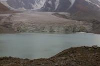
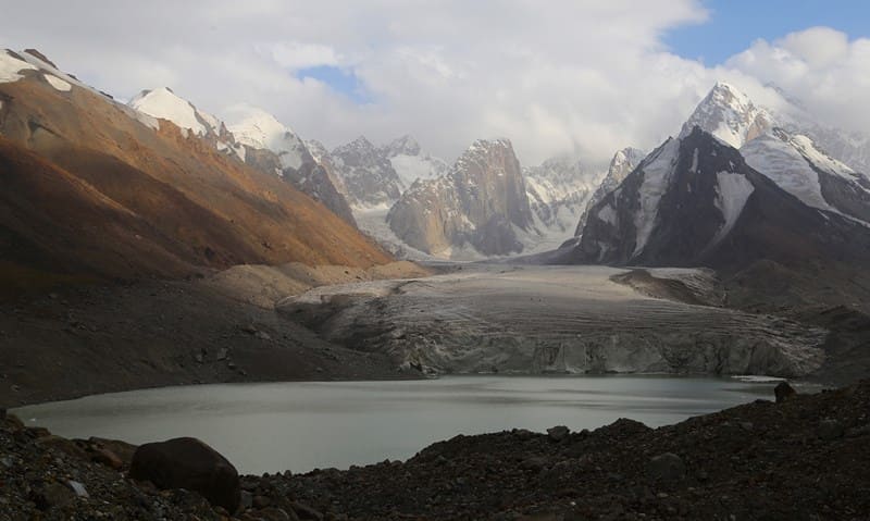
Lake Kyzyl-Asker East.
Glacial lakes in Kakshaal-Too ridge.
“To the west, on the border with Kashgaria, another ridge, Kokshal-tau, rises, significantly inferior in height to the Khan-Tengri group, but still has large reserves of snow and a number of significant glaciers.”
“Explorations in Naryn Valley.” V.V. Sapozhnikov. 1913.
Trip along northern slope of Kakshaal-Too ridge.
Glacial, dammed, flowing, freshwater lake Kyzyl-Asker East is located at an altitude of 3848 meters above sea level, at end of tongue of glacier of same name, in Kyzyl-Asker mountain range, on northern slope of west part of Kakshaal-Too ridge in At-Bashinsky district of Naryn region.
Icefall of the Kyzyl-Asker East glacier drops ice into the glacial-dammed lake of the same name. The exact date of the lake's formation is unknown, but it is safe to say that in 1988 this lake, like the Kyzyl-Asker West lake, did not exist. This fact was established by mountaineering participants in 1988, who took part in the expedition of the Central Asian Military District (SAVO) from the sports club SK-12.
The general management of the expedition was entrusted to the head mountaineering coach E. T. Ilyinsky, the ascents were led by the famous mountaineer V. N. Sedelnikov. The ascent was timed to coincide with the championship of the USSR Mountaineering Federation.
The first ascent was planned for an unnamed peak 4850 meters above sea level, after the completion of the ascent the peak was given the name - Verny. The lake is formed by a melting glacier and a snow-firn layer covering the glacier above the feeding boundary.
Since the mid-XIXth century, anthropogenic deglaciation has been occurring due to global warming. The lake is an element of the nival-glacial zone, which determines the size of the glacier in proportion to the size of the lake. The tongue of the Kyzyl-Asker East glacier ends in a flowing, freshwater lake at an altitude of 3885 meters above sea level.
The northern part of the glacier breaks off into the lake. The vertical wall of the glacier tongue rises above the lake by more than 20 meters, it is cut by extended cracks with broken-off and overhanging masses of the glacier, periodically multi-ton masses of ice break off from the glacier, which collapse with noise and rumble into the water surface of the lake.
At some time, there was a shift on the glacier, which formed a kind of dam in front of the glacier tongue. The surface part of the glacier is broken into vertical blocks, lateral faults appear along the sides, and medial moraines bend into loops. The general cause of glacier movement is the accumulation of ice mass in conditions where its flow is hampered by the narrowness of the valley, moraine cover, etc.
Such accumulation creates conditions of instability that cause ice runoff: large chips, heating of the ice with the release of water during internal melting, a decrease in the contact area on the bed, the appearance of water and water-clay lubrication on the chips, etc.
Glacier movement is very dangerous due to the damming of lateral valleys by ice, the emergence and breakthrough of glacial-dammed lakes. Water began to accumulate between the dam and the glacier, which, when heated by the sun's rays, contributed to the melting and destruction of the end of the glacier.
Thus, a lake began to form and increase in size. The length of the lake from north to south is 935 meters, the greatest width in the central part reaches 700 meters, the area of the lake is 0.51 square kilometers, the length of the coastline reaches 2.85 kilometers.
The lakes are separated by a glacial moraine 1300 meters long, in the middle of which there is a channel through which water from Lake East flows into Lake Kyzyl-Asker West. It should be noted that Lake West is more than 5 meters below the level of Lake East.
On the northern side of the lakes there is a powerful frontal moraine more than 1500 meters long, which stretches from east to west. The width of the moraine reaches almost 800 meters. In front of Lake Kyzyl-Asker East there is a more powerful moraine than at Lake West, the characteristic channel for the flow of water from the lake is absent. It should be noted that there is practically no water in the channel, the channel is dry.
Most likely, the water flow from the lake is filtered through underground channels. There are 5 large and several small lakes on the moraine. The moraine is favored by herds of argali, which settle in small groups among the rocks to rest.
Geographic coordinates of Lake Kyzyl-Asker East: N41°06'05 E77°20'10
Authority and photos by:
Alexander Petrov.