


![]()
Вы здесь
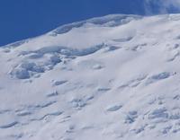
Turo Glacier.
Natural monuments of Tajikistan.
“If your friend becomes your enemy, then love him so that the tree of friendship, love and trust, which withered because it was not watered with the water of friendship and was not cared for, will bloom again.”
Muhammad ibn Ali As-Samarkandi.
Trip from town of Ayni along right bank of Zeravshan.
Turo glacier is located on southern slope of Turkestan ridge, in upper reaches of river of same name, in Kukhistoni-Mastchokh district, Sogd region. The glacier belongs to the Zeravshan River basin. The Turo River, 11.8 kilometers long, flows from the glacier and is the first, right tributary of the Zeravshan River.
The sources of the river are located at an altitude of 3289 meters above sea level. The mouth of the river is located at an altitude of 2443 meters above sea level. The Turo valley glacier, its length is 3 kilometers, area 2.2 square kilometers, the end of the glacier is located at an altitude of 3920 meters above sea level. The glacier tongue is located under the terminal moraine.
Historical information about Turo glacier.
Observations of the glacier began in 1959. The glacier is in the stage of degradation, its surface is settling by an average of 1 meter per year. The tongue of the glacier retreated from 1976 to 1988 on average 1 - 2 meters per year, but from 1988 to 1990 it retreated by 61 meters, that is, 30 meters per year, and from 1990 to 1991 it retreated another 23 meters.
Thus, we can conclude that the process of glacier degradation gradually intensified by the end of the twentieth century.
Geographic coordinates of Turo glacier: N39°31'38 E70°09'04
Authority:
"Glaciers of Tajikistan". Ministry of Nature Protection of the Republic of Tajikistan. Main Directorate for Hydrometeorology and Natural Environment Observations. Dushanbe. 2003.
Photos by:
Alexander Petrov.