


![]()
Вы здесь
Burial ground Karakuduk.
")
Ancient burial mounds in Kazakhstan.
“Look at the world.
How to unravel all the secrets of nature?
The more you look, the more confusion grows.
And in the essence of the sun, and the ray, and the atom in the ray
Partially, maybe my mind will find its way.
But how can I comprehend my coming into the world, and how can I comprehend my departure?..”
Turkic medieval Sufi poet Alisher Navoi.
Burial grounds in Kazakhstan.
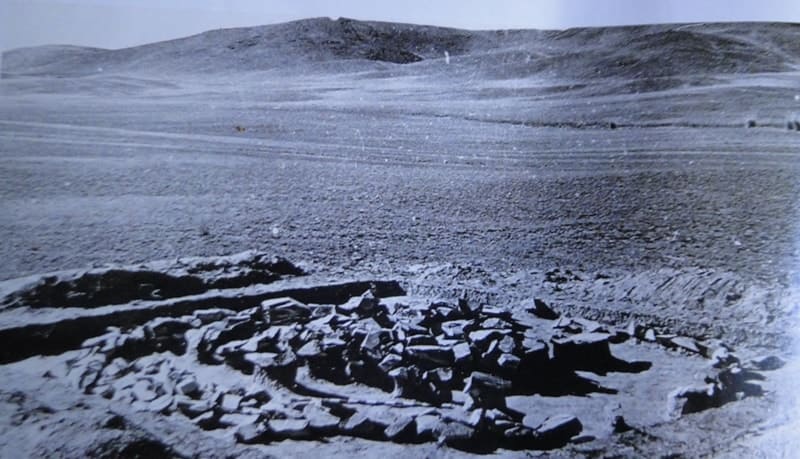
Karakuduk burial grounds are located at an altitude of 882 m. a. s. l., located in southeastern part of Karakyr Mountains, in small Tamgaly gorge, 225 meters from drying, salty bed of Tamgaly, 5 kilometers northwest of village of Karabastau, 127 kilometers on northwest of Almaty in Zhambyl district in western part of Almaty region.
Karakudyk (Karakuduk) - includes an ancient settlement and burial mound that arose in the era of early nomads (Saxo-Hunnic period). The burial ground includes four mounds and five enclosures with stone and earthen embankments. The burial grounds of the complex are located both in the hilly and flat parts of the tract.
Based on their design features, there are two types of burials: stone fences with boxes and cists inside and mounds with stone-earth embankments over the graves.
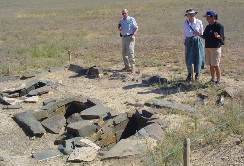
History of exploration of Karakuduk burial ground.
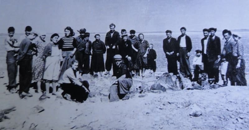
The monument was opened and explored on September 9 - 24, 1957. Semirechensky detachment of the South Kazakhstan archaeological expedition of the Academy of Sciences of the Kazakh SSR under the direction of. A.G. Maximova; excavations were carried out by A. M. Orazbaev, A. A. Charikov, O. M. Gryaznov and others.
Pottery shards were found on the territory of the settlement and burial ground. Most of the burials date back to the 1st century AD. e. They also contained hairpins, a knife and jewelry made of stone, bronze and iron. The bodies of the buried were oriented with their heads to the southeast.
Five burials of a later period (XIII - XVI centuries), covered with stone slabs, were excavated in two enclosures. The arrangement of these burials shows the influence of Islam, and the bodies of the buried are oriented with their heads to the north-west.
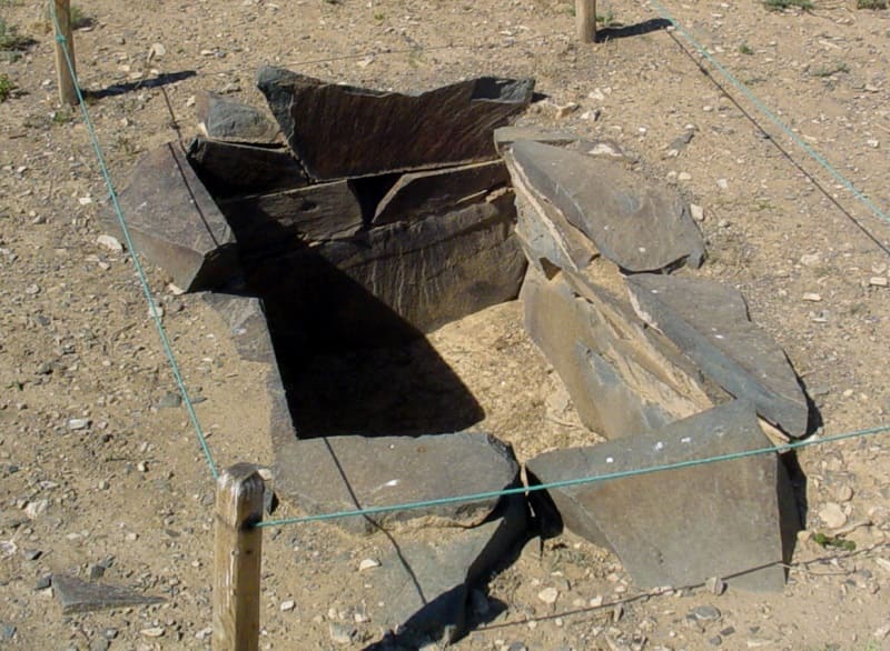
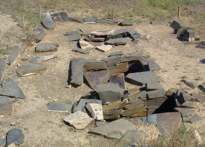
Burial ground Karakuduk I.
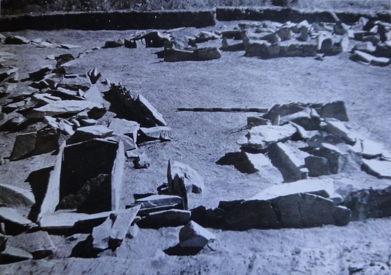
Stone boxes and cists. Bronze Age (XII-XII centuries BC). The monument belongs to the Semirechye variant of the Andronovo culture. The burial ground was the first Bronze Age burial ground explored in Zhetysu. The burial ground consists of 4 cists with burials of adults (No. 26-29) and 25 stone boxes with burials of children, symbolic cenotaph graves.
The remains of the buried and accompanying items were found in the graves: clay vessels, jewelry (earring, beads, clam shell) and a bronze plaque mirror. On the wall of stone box No. 22 a petroglyph was found - an image of a goat. During excavations of the burial ground, on September 19, 1957, photographer A. A. Popov discovered petroglyphs in the Tanbaly gorge.
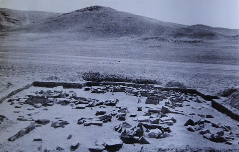
Ritual altars were also found here; early Iron Age (V - III centuries BC). The monument was explored on September 21-24, 1957 by the Semirechensky detachment of the South Kazakhstan archaeological expedition of the Academy of Sciences of the Kazakh SSR under the leadership. A. G. Maksimova.
Three ritual stone fences (altars) were intended for performing rituals in honor of deceased ancestors. Inside the middle fence there was a stone-stele (“deer” stone) with images of weapons - a quiver with a bow and a hammered battle axe. To the north of the fences there is a group of large “royal” mounds of the Saka culture.
Tanbaly II burial ground.
Northern part of the burial ground: stone fence and cists; Bronze Age (XII-XII centuries BC). The monument was discovered and explored in 1982 by an archaeological expedition of the Kazakh Pedagogical Institute named after Abai under the leadership. A. N. Maryasheva.
The monument belongs to the Semirechye variant of the Andronovo culture. In the fence with an extension there are four cist graves made of untreated stones. The cists contained the burned remains of those buried (three men and an elderly woman) and accompanying grave goods: unornamented clay vessels and bronze jewelry (beads).
Cremation took place outside the graves; burnt bones from all parts of the skeleton were scattered along the bottom of the graves. The southern part of the burial ground consists of stone cists and boxes with burials of adult women, teenage girls and symbolic cenotaph graves from the same period.
The dead were buried crouched, on their left side, with their heads to the west. Objects of grave goods were found in the graves: unornamented clay vessels and bronze jewelry (earrings, beads). For the construction of two cists, stones with petroglyphs were used: in cist No. 9 there is an image of a circle with a line extending from it (possibly a sketch of the figure of a “sun-headed” deity); in cyst No. 11 on three stones there are images of adorants (people praying), a bull (?), a goat, etc.
Tanbaly IV burial ground.
Located in the extended part of the river valley. Tanbaly, on the right bank of the valley. The burials are located on an elevated area of the second floodplain terrace, covered by slope colluvium and crossed from the east and west by two erosion valleys.
About 10 burial structures - cists in the enclosures and boxes adjacent to the outside - form a continuous chain of west-southwest orientation. One cyst in the fence is located separately 3 - 4 meters to the east. Excavations were carried out in 1992 by the Tamgaly archaeological team of the Institute of Architecture of the National Academy of Sciences of the Republic of Kazakhstan under the leadership of A.E. Rogozhinsky.
In the eastern part of the burial ground, four burials were examined. The grave goods include vessels, bronze beads and two sets of temple rings with a bell and a spiral ending. The typology of funeral structures, grave goods, as well as absolute dates make it possible to determine the dating of the burial ground in the range of the XIIIth - XIIth - Xth centuries. B.C e.
Burial ground of Tanbaly V.
It is located on an alluvial fan 170 meters south of the Tanbaly IV burial ground. The territory of the burial ground is occupied by the remains of modern residential and outbuildings. The edges of the stone box and fence protrude on the surface. The dimensions of the fence are 3x3 meters. Dating: Bronze Age.
To the west of the fence there is a mound. The mound embankment was destroyed by the road. The tentative dating of the mound is the Early Iron Age.
Tanbaly VI burial ground.
The burial ground is the largest burial ground of the Bronze Age complex of Tanbaly. The burial ground is located in the expanded part of the river valley. Tanbaly, on the second terrace above the floodplain, covered by the alluvial fan of a dry valley.
The planigraphy of the burial ground includes a system of square and rectangular fences, in two or three rows adjacent to each other in the submeridional direction. The area of the main part of the burial ground is about 1500 square meters. Excavations of the burial ground were carried out in 1986 by the expedition of the KazPI named after Abai (led by A.N. Maryashev) and in 1989-1894.
Tamgalinsky archaeological team of the Institute of Archaeology of the National Academy of Sciences of the Republic of Kazakhstan under the leadership of A.E. Rogozhinsky. Two lines of rectangular fences have been partially exposed. Inside the fences there is one burial in a box or cist.
To the north and east, near the fences, there are “children’s” boxes. Burials according to the rites of cremation and corpse deposition were discovered. The dating of the monument is established according to the typology of things and on the basis of radiocarbon dates in the interval of the second half of the XIV-XII-XI centuries. BC.
Geographic coordinates of Karakuduk burial grounds: N43°48'24 E75°32'05
Authority:
https://tanbaly.kz/burial-grounds
Photos by:
Alexander Petrov.