


![]()
Вы здесь
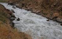
Dzhangart River.
Traveling in mountains in Central Tien-Shan.
“Follow your path and let people say what they want.”
Mountains rivers in Kyrgyzstan.
Dzhangart River is located at an altitude: sources are 3685 meters above sea level, mouth of river is at an altitude of 2341 meters above sea level, river is right tributary of Akshiyrak River, originates from northern slopes of eastern part of Kokshaal-Too ridge, is located in Jety-Oguz region in south Issyk-Kul region.
17.9 kilometers after the Tashlysu River flows into Akshiyrak, a large and full-flowing tributary Dzhangart with a length of 31.3 kilometers adjoins on the right. 33.2 kilometers from the beginning of the source (the confluence of the Cholok-Koichisai and Kayche rivers), the Dzhangart River flows into Akshiyrak from the right.
At the confluence of the Dzhangart and Akshiyrak rivers, 1.1 kilometers remain before their confluence with the Saryjaz River. The river receives its sources from six large valley glaciers located on the northern slope of the Kokshaal-Too ridge (the description of the glaciers is presented from east to west).
The easternmost tributary flows from the Chuloktor Western glacier with a length of 11 kilometers. The glacier is located on the northern slope of the Kokshaal-Too ridge; its sources are located at an altitude of 4971 meters above sea level. The glacier's area is 10.72 square kilometers. The perimeter of the glacier is 26.56 kilometers.
Geographic coordinates of Chuloktor Western glacier: N41°41'15 E78°59'35
The next river flows from the Akoguz Vostochny glacier with a length of 7.3 kilometers. The glacier is located on the northern slope of the Kokshaal-Too ridge; its sources are at an altitude of 4911.2 meters above sea level. The glacier's area is 5.05 square kilometers. The glacier's perimeter is 15.39 kilometers.
In the middle part, between the Chuloktor Western and Akoguz Eastern glaciers, there is an unnamed peak 5318 meters above sea level.
Geographic coordinates of Akoguz Eastern glacier: N41°41'43 E78°56'51
The next tributary flows from the Akoguz Central glacier with a length of 6.6 kilometers. The glacier is located on the northern slope of the Kokshaal-Too ridge; its sources are at an altitude of 4275.2 meters above sea level. The glacier's area is 9.11 square kilometers. The glacier's perimeter is 17.98 kilometers.
Geographic coordinates of Akoguz Central glacier: N41°40'29 E78°55'53
The next tributary flows from the Akoguz Western glacier. The total area of the glacier is 8.07 square kilometers. The glacier has two branches - eastern and western. The length of the eastern branch of the glacier is 5.4 kilometers. The area of the eastern branch of the glacier reaches 4.08 square kilometers, the perimeter of the glacier is 11.38 kilometers.
The length of the western branch of the glacier is 5.2 kilometers. The area of the eastern branch of the glacier reaches 3.3 square kilometers, the perimeter of the glacier is 11.6 kilometers. The glacier is located on the northern slope of the Kokshaal-Too ridge; its sources are located at an altitude of 4805 meters above sea level.
In the upper reaches of the Akoguz Western glacier in its southern part there is an unnamed peak 5291 meters above sea level
Geographic coordinates of Akoguz Western glacier: N41°40'42 E78°54'12
The next tributary flows from the Dzhangart-Tynbashi East glacier. The area of the glacier is 9.06 square kilometers, the perimeter of the glacier is 23.3 kilometers. The length of the glacier is 8.7 kilometers. The glacier is located on the northern slope of the Kokshaal-Too ridge; its sources are located in the main ridge at an altitude of 5060 meters above sea level.
Geographic coordinates of Dzhangart-Tynbashi Eastern glacier: N41°38'44 E78°53'48
The next tributary flows from the Dzhangart-Tynbashi Central glacier. The area of the glacier is 16.91 square kilometers, the perimeter of the glacier is 22.84 kilometers. The length of the glacier is 8.1 kilometers. The glacier is located on the northern slope of the Kokshaal-Too ridge; its sources are located in the main ridge at an altitude of 5048 meters above sea level.
Geographic coordinates of Dzhangart-Tynbashi Central glacier: N41°37'49 E78°52'04
The next tributary flows from the Dzhangart-Tynbashi Western glacier. The area of the glacier is 5.51 square kilometers, the perimeter of the glacier is 16.26 kilometers. The length of the glacier is 5.51 kilometers. The glacier is located on the northern slope of the Kokshaal-Too ridge; its sources are located in the main ridge at an altitude of 4977 meters above sea level.
To the west of the Dzhangart-Tynbashi Western glacier there is the Dzhangart Pass, 4181.7 meters above sea level, through which in Soviet times geologists built a survey and technological road. In the northern part, the glacier is strongly torn by transverse cracks.
The Dzhangart-Tynbashi Western glacier in the northern part ends in a vast, moraine lake with a length of 1.06 kilometers, the greatest width of the lake in the central part is 440 meters. The area of the lake reaches 0.38 square kilometers, the length of the coastline is 2.73 kilometers. The tongue of the glacier ends in a semicircle into the lake. The lake is located on the moraine part of the glacier.
Geographic coordinates of Dzhangart-Tynbashi Western glacier: N41°40'07 E78°49'37
The next tributary flows from the Dzhangart-Tynbashi Western glacier. The area of the glacier is 5.51 square kilometers, the perimeter of the glacier is 16.26 kilometers. The length of the glacier is 5.51 kilometers. The glacier is located on the northern slope of the Kokshaal-Too ridge; its sources are located in the main ridge at an altitude of 4977 meters above sea level.
To the west of the Dzhangart-Tynbashi Western glacier there is the Dzhangart Pass, 4181.7 meters above sea level, through which in Soviet times geologists built a survey and technological road. In the northern part, the glacier is strongly torn by transverse cracks.
Geographic coordinates of Dzhangart River: N41°47'34 E78°57'10
Right tributary of Dzhangart River.
Sauktor River.
12 kilometers before the confluence of the Dzhangart River with the Akshiyrak River, the 12.8-kilometer-long tributary Sauktor flows into Dzhangart on the right. After 8.4 kilometers from the beginning of the sources of the Dzhangart River, the Sauktor River flows into the right.
In the upper reaches, the river is formed from four main tributaries, which originate from glaciers: Sauktor, Sauktor West, Kichik Sauktor and Chuloktor East. In addition to the main tributaries described below, 5 small tributaries flow into the Sauktor River on the right and 4 on the left.
The easternmost tributary flows from the Sauktor glacier. The area of the glacier is 9.45 square kilometers, the perimeter of the glacier is 24.32 kilometers. The length of the glacier is 9.6 kilometers. The glacier is located on the northwestern slope of the Kokshaal-Too ridge; its sources are at an altitude of 5190 meters above sea level. In the southeastern part of the glacier there is the Sauktor pass with a height of 4583.6 meters above sea level.
Geographic coordinates of Sauktor glacier: N41°43'55 E79°06'26
To the east of the Sauktor glacier, behind a small latitudinal spur, there is the Sauktor Western glacier with a length of 4.7 kilometers. The area of the glacier is 3.6 square kilometers, the perimeter of the glacier is 12.15 kilometers. The sources of the glacier are located at an altitude of 5190 meters above sea level.
Geographic coordinates of Sauktor Western glacier: N41°44'09 E79°04'21
The middle tributary flows from the Kichik Sauktor glacier. The area of the glacier is 7.19 square kilometers, the perimeter of the glacier is 19.96 kilometers. The length of the glacier is 8.3 kilometers. The glacier is located on the northwestern slope of the Kokshaal-Too ridge, the sources of the glacier are in the main ridge at an altitude of 5025 meters above sea level.
In the southern part of the ridge, in the main ridge of the Kokshaal-Too ridge, there is the Kichik-Sauktor pass, 4678 meters above sea level.
Geographic coordinates of Kichik Sauktor glacier: N41°43'04 E79°03'08
The next tributary flows from the Chuloktor Vostochny glacier. The area of the glacier is 5.58 square kilometers, the perimeter of the glacier is 15.84 kilometers. The length of the glacier is 4.9 kilometers. The glacier is located on the northwestern slope of the Kokshaal-Too ridge; its sources are located in the main ridge at an altitude of 5025 meters above sea level.
Geographic coordinates of Chuloktor Eastern glacier: N41°42'30 E79°01'09
Geographic coordinates of Sauktor River: N41°45'46 E79°03'04
Left tributaries Dzhangart.
Achiktyshsay River.
After 6.1 kilometers from the beginning of the source, a small tributary of 3.8 kilometers long, Achiktyshsay, flows into Dzhangart on the left, at an altitude of 3448 meters above sea level. Achiktyshsay originates from the Achiktyshsay glacier located in the ridge between the Akshiyrak and Dzhangart rivers, stretching from west to east and northeast for 35 kilometers. In this ridge, in its central part, there is a vast area of glaciation stretching from southwest to northeast for 20 kilometers. The area of the glacier is 1.38 square kilometers, the perimeter of the glacier reaches 8.1 kilometers. The length of the Achiktyshsay glacier is 3.9 kilometers. The sources of the glacier are located at an altitude of 4891 meters above sea level.
Geographic coordinates of Achiktyshsay River: N41°42'39 E78°51'38
Tuzmasai River.
3 kilometers after the Achiktyshsay River flows into Dzhangart, a small tributary of 4.1 kilometers long, Tuzmasai, flows into the left. In the upper reaches, the Tuzmasai River is formed from two tributaries. One of the tributaries originates from the Tuzmasay glacier located in the eastern slope in the ridge between the Akshiyrak and Dzhangart rivers, stretching from west to east and northeast for 35 kilometers.
In this ridge, in its central part, there is a vast area of glaciation stretching from southwest to northeast for 20 kilometers. The area of the Tuzmasay glacier is 0.85 square kilometers, the perimeter of the glacier reaches 4.18 kilometers. The length of the Tuzasai glacier is 1.4 kilometers. The sources of the glacier are located at an altitude of 4361 meters above sea level.
Geographic coordinates of Tuzmasay River: N41°43'30 E78°53'24
Aksai River.
After 11.2 kilometers from the beginning of the source, a small tributary of 2.7 kilometers long, Aksai, flows into Dzhangart on the left. In the upper reaches, the Aksai River is formed from two small tributaries. The main tributary originates from the small Aksai glacier located on the eastern slope in the ridge between the Akshiyrak and Dzhangart rivers, stretching from west to east and northeast for 35 kilometers.
In this ridge, in its central part, there is a vast area of glaciation stretching from southwest to northeast for 20 kilometers. The area of the Tuzmasay glacier is 0.86 square kilometers, the perimeter of the glacier reaches 4.09 kilometers. The length of the Tuzasai glacier is 1.5 kilometers. The sources of the glacier are located at an altitude of 4730 meters above sea level.
Geographic coordinates of Aksai River: N41°43'57 E78°54'40
Sarytor River.
After 17 kilometers from the beginning of the sources, the Sarytor tributary, 5.2 kilometers long, flows into Dzhangart on the left. In the upper reaches, the Sarytor River is formed from two tributaries, which merge at an altitude of 3307 meters above sea level.
The main tributary originates from the small Sarytor glacier located on the eastern slope in the ridge between the Akshiyrak and Dzhangart rivers, stretching from west to east and northeast for 35 kilometers. In this ridge, in its central part, there is a vast area of glaciation stretching from southwest to northeast for 20 kilometers.
The area of the Sarytor glacier is 0.35 square kilometers, the perimeter of the glacier reaches 2.52 kilometers. The length of the Tuzasai glacier is 0.81 kilometers. The sources of the glacier are located at an altitude of 4730 meters above sea level.
Geographic coordinates of Sarytor River: N41°45'33 E78°55'51
Kichitashlu River.
After 19.8 kilometers from the beginning of the source, the 4.5-kilometer-long tributary Kichitashlu flows into Dzhangart on the left. The Kichitashlu River originates from the eastern slope of the ridge in the interfluve of Akshiyrak and Dzhangart, stretching from west to east and northeast for 35 kilometers. The sources of the river are located at an altitude of 4595 meters above sea level.
Geographic coordinates of Kichitashlu River: N41°47'26 E78°56'12.89"
Authority and photos by
Alexander Petrov.