


![]()
Вы здесь
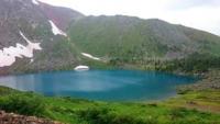
Podbelkovoe Lake in Ivanovskiy Range.
Trip to Lake Podbelkovoe (Radovnovoe) from Ridder.
“Do I look into the blue where the eagle is circling,
Where a camel caravan sails into the horizon,
To the sea or the steppe, to the mountain peaks -
I see only your whole world eclipsed."
Baba Tahir. “Both heaven and earth...” End of X – XI centuries.
Radon lake in Kazakhstan Altay.
Fresh, flowing, moraine Lake Podbelkovoe is located at an altitude of 1903 meters above sea level, located on northern slope of Ivanovskiy ridge, 1.9 kilometers north-west from peak of Vysheivanovsky Belok at an altitude of 2778 meters above sea level, 10.7 kilometers above south and a little east of village of Poperechnoye, 23.3 kilometers east and slightly south of town of Ridder, on territory of town administration of town of Ridder, in eastern part of East Kazakhstan region.
The area of the lake reaches 88,716 square meters, the length of the coastal zone reaches 1,100 meters. The Podbelkovy stream, 9.7 kilometers long, flows out of the northern part of the lake, which is the left tributary of the Poperechnaya River.
In the northern part of the lake there is a natural, ancient moraine, which served to form the lake. 1 kilometer northwest of the lake is the peak of SAVO (Central Asian Military District), 2456 meters above sea level.
The length of the lake from southwest to northeast is 400 meters, the greatest width in the central part of the lake is 335 meters. 395 meters south of Podbelkovoe Lake there is a small flowing, nameless, moraine lake 210 meters long.
In the early 70s of the last century, the Ridder Polymetallic Plant undertook a search for new developments in order to identify metal deposits. A technological road was built to the lake and to the adit developments. In 1975, next to the lake, the first trial adit was developed.
At this time, a stream flows out of the adit. There is an assumption that radon is present in the lake, so sometimes this lake is called Radon. The lake is incredibly beautiful. The color of the water during the day can change several times from bright blue to lead-black.
Lake Podbelkovoe is a local natural attraction and is often visited by tourists. The length of the highway from Lake Podbelkovoe to the Ridder highway - the border of the Republic of Kazakhstan and the Russian Federation is 10 kilometers.
Geographic coordinates of Podbelkovoe Lake: N50°18'52 E83°50'41
Authority:
Alexander Petrov.