


![]()
Вы здесь
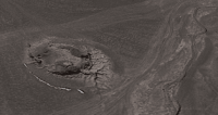
Murghab crater.

Meteor craters in Tajikistan.
"The researcher must have boundless faith - and yet still doubt"
Claude Bernard.
Mysteries of Pamirs in Tajikistan.
The Murghab crater is located at an altitude of 3686 meters above sea level, located in the northwest of the Koo-Shagyl valley, in the Eastern Pamirs, 832 meters west of the left, gentle bank of the Aksu River, 28.6 kilometers southeast of the village of Murghab , in the Murghab district of the Gorno-Badakhshan Autonomous Region in the eastern part of Tajikistan.
The Murghab crater is located between the western spurs of the Sarykol ridge, the eastern spurs of the North Alichur ridge, in the southwestern part of the Tura-Kulama ridge. The crater is round in shape. The diameter of the funnel is 51 meters, the depth is up to 18 meters.
In the early 50s, a new one appeared on the list of meteorite craters in the USSR: the Murghab crater in the Eastern Pamirs. This name was invariably accompanied by an explanation: supposed. The first researchers of the Murghab crater, who organized a special expedition to study it in 1951, were Dushanbe astronomer A. M. Bakharev and geologist S. A. Zakharov. Interest in this crater did not arise by chance.
Back in 1927, a short message by geomorphologist Kh. D. Klyavin entitled “The Mystery of the Pamir Heights” appeared in the journal “Science and Technology.” The author of the note, according to local Kyrgyz people who call the Cholgan crater Tumshu (“the place where a fiery star, lightning fell”), conveyed the stories of eyewitnesses of the fall of an alleged meteorite.
They said that this happened 200 - 250 years ago, when in the morning a fireball the size of a kutas (the Pamir name for a yak) flared up high in the sky. From the nearest Kyrgyz camp they saw how the ball split into several parts, and a terrible crash was heard.
One large luminous fragment fell to the ground, "emitting a sharp spear of red color." Then a rumble was heard, an explosion was heard and “the earth shook as if from a falling rock.” For some time, bluish lights shone from the deep hole at the crash site; for a long time they did not dare to approach it, since “a lot of fire and steam” was coming from below.
Much later, a kutas fell into the crater. They tried to get it, but a rope of 20 lasso (1 lasso - 9 meters) never reached the bottom. According to the stories of the aborigines, somewhere in the 70s of the last century, the walls of the crater began to crumble and it gradually began to fill with earth.
In the 20s of the last century, according to measurements by Kh. D. Klyavin, the depth of the funnel was 15 - 18 meters, and its circumference at the top was approximately 400 meters. The colorful descriptions of the meteorite fall were so plausible that the first researchers did not have the slightest doubt about the truth of what happened.
After all, the Kyrgyz nomads could not just come up with a completely reliable picture of such a rare phenomenon of a meteor-bolide-meteorite; in addition, among them there were no literate people who were at all familiar with the scientific literature of that time.
True, the light effects observed after the fall and the colossal depth of the crater with its relatively small diameter seemed somewhat exaggerated. But all this could be attributed to a completely understandable fear and superstition of the “holy lightning of Allah.”
And the first special observations and discoveries made more than 30 years ago, at first seemed to completely confirm the legend told. From the north, the relatively low Mynkhadzhir limestone massif, composed of rocks of Permian-Triassic and Jurassic age, approaches the Murghab crater, and to the west and south of the crater lies the endless Koo-Shagyl tract, as flat as an airfield.
In this entire multi-kilometer space, perhaps one crater is a pronounced depression in the relief. All other depressions are confined to dry beds of temporary watercourses, which have slightly curved and strongly smoothed outlines.
The crater itself, to a depth of 5 - 8 meters, is a rounded funnel-shaped expansion with a diameter of 80 meters, and in the lower part it is characterized by an almost regular cylindrical shape with a diameter of 45 meters.
Its steep walls, composed of small rubble and pebbles, are furrowed in places with narrow gullies from melt water. The bottom of the crater is very uneven, hilly due to the collapse and washing away of the upper part.
In the northwestern corner is a rounded depression, rumored to have been dug “for luck” by a lone prospector somewhere back in the 1930s. It remains unknown whether the unknown digger was lucky enough to find something or whether he, like many amateur seekers of “tillo” (Taj. - gold), was disappointed. It must be said that the main Murghab crater also has a small satellite - a bowl-shaped funnel with a depth of 1.5 and a diameter of 16 meters, located 263 meters to the south.
Even according to the most rigorous assessment of the possible causes of the formation of the Murghab crater and its satellite, their meteorite origin could not cause sharp objections among specialists. Indeed, karst formation was rejected due to the absence of easily soluble rocks at depth, and the permissible suffusion or thermokarst subsidence of loose sediments of the river terrace could not explain the regular well-shaped shape of the main crater.
So it turned out that his cosmic birth was most likely. Now all that remained was to find at least fragments, small particles of the culprit of the incident - the meteorite. However, neither the first expedition nor the second, undertaken in 1953 and equipped, by the way, with magnetometric equipment, discovered meteoric matter.
True, with the help of mine detectors several pieces of highly ferruginous rocks were found; elevated iron and nickel contents were also recorded in samples taken directly from the bottom and walls of the crater. All this, of course, led to corresponding thoughts that, for example, the meteorite could be from the group of iron ones for which nickel admixture is common.
The absence of the meteorite body itself ultimately had to be explained by its complete evaporation at the moment it hit the ground. It is curious that it was precisely this point of view that was adhered to by the famous meteorite specialist L.A. Kulik, who compared the Murgab mystery with the Tunguska catastrophe that erupted in the Siberian taiga on June 30, 1908.
The fall of the Tunguska meteorite, observed from afar, at a distance of many tens and even hundreds of kilometers, caused a massive fall of trees and a large forest fire. And this is not surprising, since the temperature of hot gases during the explosion of meteorites reaches several thousand degrees.
But in this case, the Murghab alien had to inflict some kind of “burns”, if not on vegetation, which in the Eastern Pamirs, except for low teresken bushes, is practically non-existent, then at least on nearby rocks. And already on the first expedition, scientists drew attention to the brown-black ferruginous crusts covering the limestone rocks of Mynkhadzhir near the crater.
These crusts, from 2 to 5 millimeters thick, had a characteristic bubbly structure and were very similar to the products of melting and slagging. But, unfortunately, a microscopic study of these “burns” did not bring any clarity, and this question remained in the air, without finding a subsequent resolution.
And the entire subsequent fate of the Murghab crater was surprisingly unsuccessful; the first outbreak of interest in it quickly faded due to the lack of direct evidence of meteorite origin. Fortunately, none of the experts raised their hand to make a final and ruthless decision, crossing off this object from the list of even “alleged” ones.
This was explained not only by the absence of other, more or less provable versions, but also by the amazing proportionality of the Murghab crater: the ratio of its diameter and depth ideally corresponds to the logarithmic dependence long established for explosive meteorite craters (this dependence was named after the name of the scientist Baldwin who determined it).
Almost all lunar craters, many cosmogenic formations on Earth, as well as craters from explosions of aerial bombs obey Baldwin's law. Otherwise, the meteorite would have hit the Mynkhadzhir Hill without forming a crater.
Imagine the surprise of most researchers when, in the first half of the 70s, along the expected trajectory of the fall of the Murghab meteorite, massive accumulations of meteorite balls were discovered in the loose river sediments of the North Pamir rivers - products of melting and splashing droplets of meteoric matter in the atmosphere.
The dust trail of the meteorite meteorite was recorded in the terraces of the Eastern Chuguldai (near Lake Rangkul) and Uysu (north of Lake Karakul) rivers. Externally, meteorite balls were black, shiny, spherical, or had a drop-shaped, sometimes pear-shaped shape; their sizes fell within the range from 0.1 to 2.5 millimeters.
Most of the balls had a two-layer structure: an iron core and an outer crust up to 0.1 - 0.2 millimeters thick, consisting of two minerals: magnetite and wustite. As for the second mineral, scientists were immediately interested in it.
The fact is that wustite is an extremely rare mineral on Earth; in chemical composition it corresponds to ferric oxide and can be obtained artificially by oxidation of iron at temperatures above 570° C. The discovery of wustite, thus, indicated high-temperature oxidation of meteoric iron at the moment the cosmic body passed through the low layers of the atmosphere.
New data significantly strengthened the shaky positions of the Murghab crater. However, no one could guarantee that the found balls were connected specifically with the problematic funnel. This is understandable; every year 104 - 105 tons of cosmic dust not associated with meteorites fall on Earth.
In addition, microscopic balls of industrial dust accumulate on the earth’s surface in no lesser quantities, differing little in appearance and composition from cosmic ones (these are products of the activities of metallurgical, chemical and other enterprises, emitted into the air by factory chimneys).
Perhaps the last straw in favor of the cosmogenicity of the Murghab crater were the finds of our days. Geologist L.I. Ageeva, examining under a microscope a thin aggregate of minerals obtained by crushing granite samples, discovered the same magnetic balls, exactly reminiscent of the North Pamir ones.
This discovery initially caused complete bewilderment: granite is an igneous rock, formed at depth, and therefore the direct impact of balls into the crystalline melt is completely excluded. Cosmic dust most likely “leaked” into the sample from the surface of the granite outcrop.
But why then did these tiny particles not immediately separate when the samples were taken, or at least during the process of crushing the sample? The solution turned out to be completely unexpected: the cosmic balls stuck, or rather “welded” to the surface of granite rocks, while still hot.
This led to the assumption that the culprit of the incident could be a low-flying hot meteorite, quickly losing its mass due to the splashing of droplets of iron melt. Now all that remains is to add that the mentioned granites were brought from the Pamirs, the field of their distribution is located on the right bank of the Aksu River, 10 - 15 kilometers north of the Murghab crater.
The new find allows us to speak more confidently, and perhaps irrefutably, about the meteorite nature of the Murghab crater. The history of this crater, dating back almost 60 years since the first mention, once again shows how complex the fate of geological objects suspected of cosmic origin can be.
All this can fully apply to the second crater in the Pamirs - Alichur crater - which has a long history of study. unlike Murgabsky, it is just beginning.
Geographic coordinates of Murghab crater: N38°05'39.30" E74°16'57.62"
Geographic coordinates of satellite of Murghab crater - funnel: N38°05'30.87" E74°16'57.13"
Note:
If you are using geographic coordinates for Google Earth or Google Maps navigation systems, you must remove the last two digits from geographic coordinates and " (hundredths of a second) and enter the result in the input line. Example: N51°44'09.67" E72°39'40.81" = N51°44'09 E72°39'40
Authority:
Baratov Rauf Baratovich, Novikov Valery Petrovich. “Stone miracle of Tajikistan.” 2nd edition revised and expanded. Dushanbe: Ifron, 1988.
Photos by:
Alexander Petrov.