


![]()
Вы здесь
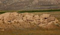
Kokand fortification Kurtka.
History Kyrgyzstan.
“During the unrest in Kokand, the Kirghiz did not obey the Kurtka commandant at all, because with the change of the khan, all authorities are usually renewed.”
Ch. Ch. Valikhanov.
Great Silk Road in Kyrgyzstan.
Kurtka fortification is located on a natural hill, at an altitude of 1643.9 meters above sea level, located in the interfluve of Naryn and Kurtka, 150 meters from the right bank of the Naryn River, 150 meters from the Aktal - Dzhangi-Talap highway, 880 meters to the south from the mausoleum of the batyrs Atantay and Tailak in the Ak-Tala district of the Naryn region.
The literature contains especially a lot of information about the Kokand fortress of Jacket, which is associated with the events of the 30s of the last century, when the Kyrgyz people began the national liberation struggle against the Kokand colonialists.
It was headed by the Kyrgyz warrior Tailak. The Kurtka fortress was protected on one side by the cliff of the Naryn River, on the other by the cliff of the Kurtka River. The other two sides, vulnerable to the enemy, were fortified with powerful walls and towers.
The recovered material collected during the expedition consisted of amorphous fragments of late ceramics and the rim of a vessel. One of them turned out to have a scratched striped pattern. The other is a type of faience fragment with a light emerald glaze.
Several meters of ash layer can be traced in the quarry - traces of a fire that once burned here. Research has shown that the fortress did not exist for long (this is confirmed by written sources) and it was founded in a new place and did not have a medieval predecessor.
Only isolated sections of the fortress have survived; the southern half was destroyed by a landslide into the Naryn River. The western part of the fortress was completely destroyed as a result of quarrying. Only the remains of the walls in the northeastern part of the fortress have survived.
On the eastern side the wall goes to the confluence of the Kurtka and Naryn rivers, and on the southern side - to the Naryn river. Traces of the northern and western walls of the fortress are visible only to specialists, but the fortress walls are completely destroyed.
The fortress was rectangular in plan, with towers located at the corners (only traces of the southeastern and northeastern towers have been preserved). Inside, the fortification was divided into two parts: southern and northern.
In the southern part, apparently, there were buildings (it is difficult to judge now, since quarrying was carried out in this place). According to sources, the fortress was built in 1832 and was also known among the Kyrgyz as Kakyr-Korgon.
In the folk poem about the heroes of the liberation struggle against the Kokand people - Tailak and Atantay, recorded by A. Chorobaev, there are the following lines:
- “Atantay and Tailak were warriors. They lived near the Kakyr-Korgon fortress, then the Kokand Khan ruled the Kirghiz, who sucked Kyrgyz blood.”
Tailak's appeals to fight against Kokand oppression found the support of ordinary Kyrgyz workers. They refused to pay extortionate taxes and rose in open rebellion.
A punitive detachment under the command of Arap-Batyr was sent to the Kurtka area; it moved from the Fergana Valley through Toguz-Toro. Here, in the area of Bycha, a battle took place between the Kokand detachment and the Kyrgyz militia that came out to meet them.
The rebels won, the punitive detachment was defeated, and Arap himself was killed. Tailak occupied the fortress, capturing 60 Kokand officials. Only after the treacherous murder of Tailak, the khan’s troops again captured Kurtka and restored the destroyed fortification.
The new commandant of the fortress, Mamrazyk, elevated Tailak's son, Osmon, even entering into a family relationship with him and granted him the ranks of pansat (colonel) and dathi - high official ranks of the khan's court.
This flattered the ambitious Osmon, who constantly kept 500 horsemen ready to serve the commandant. However, the people continued to resist the khan's despotism and the tyranny of his henchmen in Kurtka. The Cheriks, led by Turduke, rebelled repeatedly and generally refused to pay zyaket to the khan’s Kurtka proteges.
For two years, the commandant of Kurtka Mamrazyk appealed to the Andijan governor with a request to send a punitive detachment of 700 people. But the central authorities, busy with their court intrigues and feudal strife, they were unable to send a detachment to help in Kurtka.
In 1862, during a military-scientific expedition to the Tien-Shan, Captain Protsenko also visited Jacket, already abandoned by the Kokands, and left a description of it, using data from Ch. Valikhanov. Here is an extract from this archival note:
“All Tien-Shan and Naryn Kyrgyz recognize the authority of the Kokand Khanate over themselves. Most of them belong to the department of fortification of Kurtka, which is part of the Andijan governorship: some of the sayaks are subordinate to other mounds of Toguz-Torau and Dzhumgal...
The Kirghiz generally listen little to the Kokand people, and only the delay in strengthening the amanates of their honorary families keeps them in peace. But even then, disobedience happened here very often, and Jacket was even blocked several times, besieged by the Kyrgyz...”
The final fall of Kurtka as a fortification and administrative center of Kokand power occurred in 1863 as a result of the uprising of the Tien Shan Kirghiz against the Khan's yoke. The Tien Shan Kirghiz became part of Russia.
The text of the oath of citizenship read:
- “We, entrusted by the manaps, biys and other ancestors and elders of the Cherik clan, who are not subordinate to any government, promise and swear that the Cherik clan wants to be faithful, kind, obedient and eternally subject and not to enter into foreign service anywhere, also with enemies not to have sabotage frankness.”
The oath of the Kyrgyz representatives was taken in Omsk on October 13, 1863, written in Turkic and Russian. The most numerous group of Kokand fortifications were small fortresses. The individual surviving fortresses are small areas outlined by the eroded ridges of once towering walls.
Based on the surviving drawings, drawings and descriptions compiled in 1862, one can imagine the general configuration and internal layout of the fortresses Ak-Suu, Tokmak, Shish-Tyube, Tash-Kurgan and others.
As a rule, these are rectangular or oval-shaped fortifications with an area of up to 0.2 hectares. Quite high battlements with projections or towers at the corners were surrounded by a moat on the outside. The garrison consisted of approximately 20 - 50 soldiers.
He monitored the migration of the Kyrgyz and collected zekets from them, and as danger approached, he gave a distress signal and began moving to a neighboring, more powerful fortification. The literature and archives also mention fragmentary information about such Kokand fortresses of the Central Tien-Shan as Toguz-Toroo, Atbash, Kochkor and many others, but at present it has not been possible to localize them on the ground.
Almost no traces of the Issyk-Kul fortresses have survived. During the uprising of the Kyrgyz population against Kokand oppression, taking advantage of the murder of Khan Madali and the feudal strife that broke out after that in the struggle for the khan's power, the Kokand garrisons from the fortresses of Karakol, Barskaun and Konur-Ulen were expelled in 1842, the fortresses were destroyed.
As contemporaries wrote, the Issyk-Kul Kyrgyz “recognized themselves as independent and expelled the Kokand people from small fortifications built on the Karakol, Barskaun and Konur-Ulen rivers.” The power of the Kokand Khan in this area was temporarily destroyed, and thirteen years later the Issyk-Kul Kyrgyz voluntarily accepted Russian citizenship.
Turning retrospectively to the history of the Kokand fortresses and assessing their current state, we can conclude that at least of the many mentioned in the sources, only three fortresses can now be confidently localized on the ground and only four of them can be reflected in the “Code of Historical and Cultural Monuments” - these are Cholok-Korgon, Jumgal, Kan and Daraut-Kurgan.
Three of them - Cholok-Korgon, Kan and Daraut-Kurgan can be classified as monuments of republican significance.
Geographical coordinates of Kurtka fortification: N41°25'50.61" E75°02'07.02"
Authority:
https://open.kg/about-kyrgyzstan/history/1888-krepost-kurtka.html
Photos by:
Alexander Petrov.