


![]()
Вы здесь
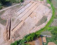
Caravanserai Shengeldy.
Caravanserais on Great Silk Road.
“A thousand chosen camels walked with him,
And there were no loads of rich people.
A hundred red camels carrying dirhams walked
And forty camels carried dinars...
With packs, where there is musk and the best scarlet,
With silks that amaze the eyes with beauty,
Their Chin supplies both Mysr and Iran -
here was another caravan of thirty camels."
Poet of the medieval East Ferdowsi.
Archaeological excavations in Almaty region.
Shengeldy caravanserai (Shengeldi) is located at an altitude of 530 m. a. s. l., located in central part of village of same name, which is subordinate to city administration of town of Konaev in Almaty region.
The first exploratory excavations of the caravanserai were carried out in 2014; based on small excavations, archaeologists came to the conclusion that there was an ancient settlement here. During the period from June 15 to July 30, 2018, the Archaeological Expedition company carried out research work on the Shengeldy caravanserai.
The area of research and excavations amounted to 1000 square meters, the monument was prepared for further museumification. The development of trade was the impetus for the construction of caravanserais, which served as transit points for trade caravans moving along the routes of the Great Silk Road.
Caravanserais were inns surrounded by walls. They combined many functions: they were hotels, trading posts, warehouses, fortified camps. International and domestic trade are closely connected with these structures. During the excavations, original information was obtained that complemented the data of scientists about the planigraphy, functioning, stratigraphy, and fortification of caravanserais located on the Semirechensky section of the Great Silk Road.
As a result of research, a large number of tools and ceramic products were discovered. The caravanserai was located at a busy crossroads of regional trade routes and connected routes coming from Central, Eastern and Southern Kazakhstan, Central Asia.
Having arisen in the Xth - XIIth centuries, the caravanserai survived several raids, was subjected to looting and destruction, and finally ceased its functioning in the XIIIth century during the period of the Mongolian internecine wars. Almost a thousand years later, through the efforts of archaeologists, it is destined to find a new life as an open-air museum.
The monument miraculously survived destruction among the surrounding houses in the village. During the excavations, archaeologists found a large amount of ceramics: remains of pots, bowls, jugs and other household utensils. At the end of the XIXth century, the settlement was explored by N.A. Abramov and N. Pantusov, in 1939 by A.N. Bernshtam, in 1969 by K. Baipakov.
Geographic coordinates of Shengeldy settlement: N43°58'49 E77°27'45
Authority and photos by:
https://www.archeology.kz/ru/1782-karavan_saraj_shengeldy.html