


![]()
Вы здесь
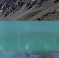
Lake Bogoshty in At-Bashi Range.
Tours from Naryn town to mountains of At-Bashi.
“The nature of our planet is secretive. And how much effort, time, patience is needed to answer her riddles! A discovery has been made. It would seem that everything is clear, but the time of joy is short. Again, many questions arise, and all of them are waiting for resolution.”
"Years of searching in Asia.". EM. Murzaev.
Lakes in At-Bishi Range.
The flowing, fresh, moraine lake Bogoshty is located at an altitude of 3809 meters above sea level, located 25 kilometers southeast of the village of At-Bashii, 13 kilometers southwest of the village of Taldy-Suu on the northern slope of the At-Bashi ridge in At-Bashinsky district of the Naryn region.
The length of the moraine lake is 380 meters, it stretches from the southwest to the northeast, the lake area is 0.07 square kilometers, the perimeter is 1.02 kilometers. The southern and southwestern parts of the lake are closely adjacent to the Tuyuk-Bogushty Zapadny glacier with a length of 807 meters.
The area of the glacier is 0.27 square kilometers, the perimeter of the glacier reaches 2.4 kilometers. From the eastern part of the lake flows the river Zhol-Bogoshty with a length of 15.5 kilometers. 1.7 kilometers northwest of the lake is the Uyurme Pass, located at an altitude of 3851.4 meters above sea level.
From the northern side of the pass flows the Uyurme Severnaya River, which is the left tributary of the At-Bashi River.
Geographical coordinates of Lake Bogoshty: N41°05'00.95" E76°04'34.19"
Authority and photos by
Alexander Petrov.