


![]()
Вы здесь
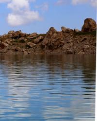
Lake Kel-Ukek.
Trip to lake Kel-Ukek from Kochkorka.
“Travel is a book. Only those who can read between the lines of observed life can read it. The one who is looking for the original, the exotic, is set "poetically", inevitably falls into error, because in normal conditions of life he is looking for the abnormal.
E.M. Murzaev.
Lakes of Northern slope in Terskey Ala-Too ridge.
The fresh, flowing lake Kel-Ukek is located at an altitude of 3048 meters above sea level on the northern slope of the western part of the Terskey Ala-Too ridge, in the eastern part of the Kekbuka mountains and in the western part of the Chunkurtor mountains, 19.3 kilometers southeast of the village of Kochkor, is located in the Kochkor district of the Naryn region.
The lake was formed as a result of an extensive landslide almost 3 kilometers long, which descended from the right (western) slope of the gorge, blocking the river. In the northern part of the lake there is a small island, which was formed as a result of subsequent landslides from the western slope.
The island formed another lake in the northern part, which tourists call the Aral. In the western part of the island there is a small channel that connects these two lakes. The length of the lake from southeast to northwest is 2.9 kilometers, the largest width in the central part reaches 770 meters.
The area of the lake is 1.5 square kilometers, the perimeter is 7.8 kilometers. From the southeast, the Kel-Ukek River, 13.2 kilometers long, flows into the lake. The sources of the river are given by two glaciers located on the northern slope of the Terskey Ala-Too ridge: the Ukek East glacier and the West Ukek glacier.
The Ukek Vostochny glacier, 880 meters long, stretches along the slope from west to northeast for almost 2 kilometers. The area of the glacier is 1.17 square kilometers, the perimeter is 5.63 kilometers. The Ukek Central glacier, 680 meters long, stretches along the slope from west to east for 3 kilometers.
The area of the glacier is 2 square kilometers, the perimeter is 8.4 kilometers. A small tributary flows into the Kel-Ukek River on the left, flowing down from the Ukek Pass, 3845 meters above sea level, located in the main ridge of the Terskey Ala-Too ridge.
Almost 5 kilometers west of the Ukek Central glacier, there is a group of Ukek West glaciers. There are two glaciers in this group. The westernmost glacier is 2.2 kilometers long. The area of the glacier is 1.04 square kilometers, the perimeter is 5.67 kilometers.
The Eastern Glacier, in this group, is 1.3 kilometers long. The area of the glacier is 1.02 square kilometers, the perimeter is 5.31 kilometers. From the south side, another river flows into the lake - the Karakum, 3.4 kilometers long. The river originates from 4 moraine lakes, three lakes are small and are located at the end of the tongues of glaciers.
One of them is the beautiful lake Kel-Tor, located at an altitude of 3478 meters above sea level. The origins of the Karakum River, it receives from 3 glaciers: Western Karakum with a length of 1.8 kilometers, Central Karakum with a length of 1.4 kilometers and East Karakum with a length of 1.8 kilometers.
The distance from the township of Kochkor to Lake Kel-Ukek is 21 kilometers. It should be noted that it is very difficult to get to the lake itself, so it is better to leave the car at the place where the road ends and walk the remaining distance (1 kilometer).
Geographical coordinates of Lake Kel-Ukok: N42°05'18.68" E75°54'59.99"
Authority and photos by
Alexander Petrov.