


![]()
Вы здесь
Khazar reserve.
Tours to Khazar Reserve.
“I miss my hometown.
Have you walked with her in the mountains?
Let me know if it's still there
Is it raining, gray fog is swirling?"
"Swans". Translation by A. Tarkovsky. Makhtumkuli.
Ecological tours to Khazar Reserve.
The reserve is located in the southeast of the Caspian Sea and the sandy coast adjacent to it, occupies the ecosystems of deserts, dry subtropics and sea shallow bays on the southeast coast of the Caspian Sea.
Administratively, the territory of the reserve is located in the Turkmenbashi and Esenguly etraps of the Balkan velayat, subordinate to the local authorities of the cities of Khazar and Balkanabat. The Khazar reserve is distinguished by the amazing richness of the animal world.
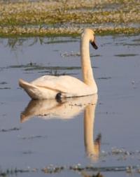
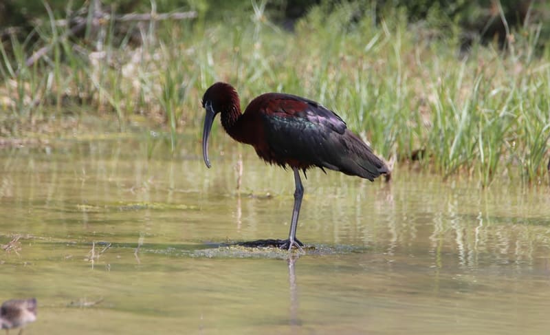
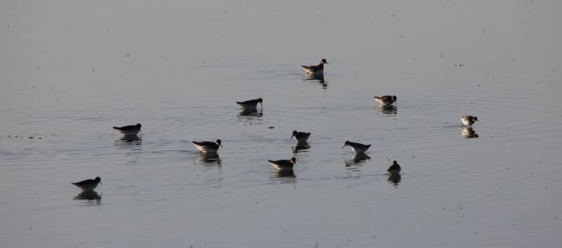
According to the Ramsar Convention, this unique corner of the Turkmen nature is recognized as a land of world importance. Only birds here there are almost three hundred species. The total area is 269,000 hectares, of which 226.6,000 hectares are strictly reserved (including about 80% of the area of the sea area, which depends on the level of the Caspian Sea - 192047 (the given data correspond to the beginning of the 1980s - before the beginning of modern transgression), 35.4 hectares - buffer zone and 7,000 hectares - reserve.
The reserve is represented by two sections, almost 300 kilometers distant from each other: Esenguly (opened in 1932 - 69.7,000 hectares) and Khazar (opened in 1968 - 192.3,000 hectares).
Esenguly section of the reserve, in turn, is divided into two parts:
- the coast itself and shallow waters between Esenguly, Chekishlyar and Okarem, and the system of lakes Small and Big Delili in the lower reaches of the Atrek.
The reserve has a buffer zone and one reserve on the Ogurchinsky island (7,000 hectares), created in 1982, located in the Caspian Sea between the Esenguly and Khazar sites.
Description of the boundaries of the Esenguly branch. Located between 53 50' - 54 30' in. and 37 20' - 37 50' s. sh.
Esenguly branch is divided into 4 sections:
The 1st section of the Esenguly branch is located north of the state border along the coastal strip of the Caspian Sea for 80 kilometers, the width of the land strip is 3 kilometers, the water area of the Caspian Sea is 4 kilometers, which is 56,000 hectares. On the traverse of the villages of Esenguly, Chekishlyar and Kuydzhuk, passages to the sea 500 meters wide are being installed.
The 2nd section of the Esenguly branch, located along the state border from the border of Gyzyl-Etrek and Esenguly etraps in the northeast to the border of the lands assigned to the Chalayuk agricultural association in the southwest. The total area of the plot is 1700 hectares.
The 3rd section of the Esenguly branch includes Lake Small Delili and the bed of the dried-up lake Big Delili. General plot area 1240 hectares. At present, Lake Small Delili has changed its shape and size: width is 1.7 kilometers, length is 4.6 kilometers, the length of the coastline is 11.5 kilometers, i.e. The lake stretched out in a northeasterly direction.
The 4th section of the Esenguly branch is located on the territory of the former Esenguly Bay. At present, the territory of this site includes the southwestern half of the Adzhiyab spawning ground. The total area of the site is 10760 hectares.
Description of the boundaries of the Khazar section. The starting point is the pier in the village of Ufra, located about 5 kilometers east of the city of Turkmenbashi. From here, the border passes through the navigable channel until it exits through the spit from the Turkmenbashi Bay, then turns southeast along the Krasnovodskaya spit, embracing the Adzhi Bay, Kyzyl-Su, and goes to the Osushnye Islands along the Bekovich spit.
From them, through the entrance to the bay, it goes in a straight line to the North Chelekenskaya Spit, crosses it to the water's edge of the North Chelekensky Bay and goes around the entire bay along its shore, then along the outer edge of the Mikhailovsky Bay it passes to Darja peninsula, goes around the entire coastal part of the Balkhan Bay, goes back to the coast Turkmenbashi Gulf.
Thus, almost the entire water area of the Turkmenbashi North-Chelekensky, Mikhailovsky and Balkhansky bays with a total area of 154,910 hectares, a section of the Krasnovodskaya Spit and the islands of Osushnye, Dag-Ata and others - a land area of 416 hectares.
Along the entire described border there is a kilometer-wide security zone: sections of the coastal water area of the Caspian Sea, with a total area of 2613 hectares, the water area of \u200b\u200bthe Turkmenbashi Gulf (18000 hectares), as well as land areas on the Krasnovodsk, North Cheleken Spit, the Darja Peninsula, along the coast of the Balkhan Bay, at the foot the Kaili-Daga ridge and on the Ufrinosky peninsula - with a total area of 16398 hectares.
Coordinates: between 52° 50 - 53° 42 E d. and 39 ° 30 - 40 10 s. sh. The movement of ships is allowed only along the shipping channels, outside - only with the permission of the reserve. The anchorage for anchoring ships during a storm is located in the area of the Osushny Islands, where launching small watercraft from ships is strictly prohibited.
The Ogurchinsky nature reserve was organized to create a reserve stock of goitered gazelles (Gazella subgutturosa Guldenstaedt, 1780). In 1982 - 1983, 13 adult gazelles were delivered from the Badkhyz State Reserve to Ogurchinsky Island.
ver the past years, there has been a systematic increase in the number of animals (by a factor of 1.6 - 1.8), which by 1999 amounted to about 1000 animals. Reserve coordinates: between 38 55 - 39 10 s. sh. and on the 53rd c. e.
Area 7000 hectares. With a reserve the large port city of Turkmenbashi, the settlements of Okarem and Esenguly are directly adjacent. All settlements are connected by highways. The city of Turkmenbashi also has a railway station, an airport and a seaport of international importance.
In terms of their accessibility, the sections of the reserve differ significantly: the Khazar branch actually adjoins the large industrial center of the country, the city of Turkmenbashi, located 1 hour by air from the capital of Turkmenistan, the city of Ashgabat.
Esenguly is located 4 - 5 hours by car from the city of Balkanabad - the administrative center of the Balkan velayat, which also has an airport of national importance; The Ogurchinsky nature reserve is accessible only to sea transport in favorable weather conditions. The central estate of the reserve is located in the city of Turkmenbashi.
Geographical coordinates of Khazar Reserve: N37°39'57.59" E53°52'40.54"
Authority:
"Reserves of Central Asia and Kazakhstan". Under the general editorship of R.V. Yashchenko. Tethys edition. Editorial Board of the Scientific Society "Tethys": R.Ya. Yashchenko chairman), O.V. Belyalov, V.P. Krivenko, O.E. Lopatin, I.V. Mitrofanov, K.M. Pachikin. Marmazinskaya N. July 25, 2006. Berkeliev T. http://iucnca.net
"Where dunes meet the sea..". Oleg Vinokurov.
Photos by
Alexander Petrov.