


![]()
Вы здесь
Chingiztau ridge.
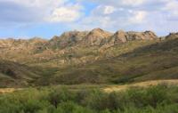
Nature of Chingiztau ridge.
“It’s important along the shore in the wreck,
Geese-swans pass imposingly.
Happy kids, up and down
- Scouring for eggs.
Gyrfalcon takes off, rushing up,
Birds are hunted on horses.
Full of prey toroka - for show,
The beauties run to the lucky ones, flattering themselves.
Abai Kunanbaev. "In anticipation of summer." Translation by M. Adibaev.
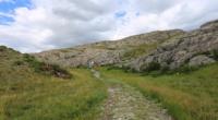
Sights in Chingiztau mountains.
Chingiztau ridge is located in the eastern part of the Kazakh uplands in the western part of the Abai region.
The northern border of the ridge runs along the watershed of the Shagan and Ashchysu rivers. The southern border runs along the watershed of the Ayagoz River. The Chingiztau ridge stretches for 208 kilometers from the southeast to the northwest, its maximum width in the northern part is 127 kilometers.
The highest peak in the Chingiztau ridge is Mount Mashan, 1158 m. a. s. l., located in the mountains of the same name in the northern part of the ridge. The second highest peak of the ridge is Mount Karakshi, 1151 m. a. s. l., located in the Aashatau mountains in the central part.
The third highest peak is Mount Sandyktas, 1125 m. a. s. l., located in the Kyzylzhartas Mountains in the southern part of the range. At 66 kilometers from the northern border of the ridge to the northwest is the low-mountain Degelen massif with a dominant peak 1084 m. a. s. l.
Until 1991, the test site "D" of the Semipalatinsk nuclear test site was located in the Degelen mountains. In total, between 1961 and 1989, 215 nuclear explosions were carried out in the Degelen mountains, all in horizontal adits. The Kent Mountains are located 245 kilometers northwest of the Chingiztau Range.
Northern part of Chingiztau Range includes small mountains and ranges:
The Karatau Mountains with the highest peak 961 meters above sea level, ridge Karazhal with the highest peak 925 m. a. s. l., the Kyzylzhal ridge with the highest peak Tokabai, 888 meters above sea level, Suykzhal ridge with the highest peak 819 m. a. s. l., Saryadyr mountains with the highest peak 1044 m. a. s. l., the long Kanchingiz ridge with the highest peak 984 m. a. s. l., Mount Kungei, located in the eastern part of the Chingiztau ridge with the highest peak 1063 m. a. s. l.
Central part of Chingiztau Range also includes small mountains and ranges:
The Kuyikadyr Mountains with the highest peak 926 m. a. s. l., the Balaurpek Mountains with the highest peak 958 m. a. s. l., the Shot Mountains with the highest peak 1039 m. a. s. l., Kyzylkaynar mountains with the highest peak 1068 m. a. s. l., Karamola mountains with the highest peak 1043 m. a. s. l., Akkoitas mountains with the highest peak 1088 m. a. s. l., Zhakpartas mountains with the highest peak 1011 m. a. s. l., the Shakpaktas mountains with the highest peak 1039 m. a. s. l., the Kungei ridge located in the western part of the Chingiztau ridge with the highest peak 944 m. a. s. l., the Karashoky mountains with the highest peak 882 m. a. s. l., Karaadyr Mountains with the highest peak 1002 m. a. s. l., Ayubay Mountains with the highest high peak 965.8 meters m. a. s. l., the Kyzylzhal Mountains with the highest peak 946 m. a. s. l., Akirek mountains with the highest peak 928 m. a. s. l., Akshatau mountains with the highest peak 883 m. a. s. l., the easternmost Okpekty mountains in the range with the highest peak 938 m. a. s. l., Konyrtau mountains with the highest peak Baltakyzyl 1038 m. a. s. l., Arsalak mountains with the highest peak 1038 m. a. s. l., Saryshoky mountains with the highest peak 1048 m. a. s. l., Kyzylzhal mountains with the highest peak 1025 m. a. s. l., Kyzylkaiyn mountains with a dominant mark 836 m. a. s. l.
Southern part of Chingiztau Range includes small mountains and ranges:
The Bopay Mountains with the highest peak 860 meters above sea level, the Zhamantas Mountains with the highest peak 1122 m. a. s. l., the Kyzylzhilak Mountains with the highest peak 1002 m. a. s. l., the Kyzylzhartas mountains with the highest peak Sandyktas 1125 m. a. s. l., the Karashok mountains with the highest peak Uygentas 912 m. a. s. l., in the southernmost part of the Chingiztau massif there are Kyzylsengir hills with the highest peak 659 m. a. s. l.
In the east, among the semi-desert latitudinal zone, stretches the Chingiztau ridge, also belonging to the region of the Hercynian folding. It is an anticlinorium elongated from the northwest to the southeast, abruptly breaks off to the northeast and descends in steps to the southwest.
The top surfaces of the ridges are leveled, plateau-like. Stony sheep, fescue and feather grass steppes dominate on the flat tops and slopes of the mountains. There are many rivers, springs and small lakes in the Chingistau mountains. Here, in the Maibulak tract, north of the Shakpaktas mountains, the sources of the Shagan River begin.
The Shagan River starts from two tributaries - Karasu and Esentai-Maibulak. In the eastern part of the ridge, the sources of the Kalgutta and Koldekek rivers begin. In the western part of the range, Mount Bakanas collects numerous tributaries and flows south.
The mountain-steppe landscape is enlivened by aspen-birch woods, willow thickets, and along the valleys of rivers and streams and near groundwater outlets - forb-cereal wet meadows. Mountain steppes are mainly used as summer pastures for small cattle.
Geographic coordinates of Chingiztau ridge: N48°37'28 E79°08'13
Authority:
Alexander Petrov.
Gvozdetsky N.A., Golubchikov Yu.N. "Mountains", series "Nature of the World". Moscow, Thought, 1987.
Photos by
Alexander Petrov.