


![]()
Вы здесь
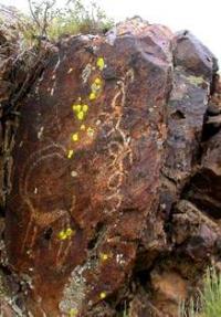
Rock paintings in Terekty gorge.
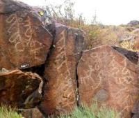
Petroglyphs in Almaty region.
"Basalt blocks of hodgepodge
bowed over the stormy river.
On the rocks - ocher painting
written by an ancient hand»
Petr Korytko.
Petroglyphs in mountains of Dzungarian Alatau.
Rock paintings in the Terekty Gorge are located at an altitude of 1120 meters above sea level, located on the right bank of the Bolshaya Terekty River, in the western, final part of the mountains of the Dzhungar Alatau, in the Eskeldin district of the Almaty region.
Rock paintings are located 2.3 kilometers southeast of the village of Bigash, which is part of the Zhalgyzagash rural district. Ancient petroglyphs date back to the Bronze Age, the Early Iron Age, and the Middle Ages. The Oirat inscriptions and accompanying images date from the end of the XVIIth to the middle of the XVIIIth centuries.
The ruins of stone structures at the bottom of the valley near the petroglyphs are the remains of residential and household buildings of the XVIIth - mid-XVIIIth centuries. The burial ground on the left slope of the valley belongs to the same period.
The location of petroglyphs and Oirat inscriptions in the Terekty gorge was discovered in 1886 by the Cossacks of the village of Koksuyskaya and the village of Zhangyz-Agach D. Kashkarov and M. Khmylev and was first examined in 1899 by N.N. Pantusov.
According to the information of the discoverers and the first researcher, there are about 60 inscriptions in the Bolshoy Terekty gorge, which is not confirmed by the studies of the monument carried out in our time. In the XXth century, in different years in the Terekty region, near the villages of Bigash and Zhalgyzagash, archaeologists E.I. Ageeva, K.M. Karabaspakova and A.N. Maryashev (in 2005 - 2006, together with M. Frachetti, USA) studied burial grounds and settlements of the Bronze Age.
The study of petroglyphs in the Terekty gorge indirectly contributed to the discovery in 1982 of petroglyphs in the nearby Eshkiolmes mountains. A field road runs along the bottom of the valley and along the left slope of the gorge from the village to the gorge.
Stone ruins are available for viewing up close; to view petroglyphs, you need to climb to the rocks, which, in the absence of well-maintained paths, is difficult or even impossible for older tourists and the disabled. Inspection of Oirat inscriptions and drawings is possible from the foot of the rocks, from the bottom of the valley (recommended).
Description of petroglyphs in the Bolshoye Terekty gorge.
At the mouth of the Terekty gorge, at the bottom of the valley, the remains of stone buildings are visible, a canal cut partially in the rocks and leading water along the high banks of the terraces to the buildings and fields located below.
On the surface of the buildings there are fragments of porcelain dishes, metal products, etc. On the right slope of the gorge, on the rocks covered with black patina, there are images of animals and anthropomorphic figures. There are several Oirat inscriptions and drawings on the vertical rocks.
On the left bank of the Terekta valley, opposite the rocks with petroglyphs, there is a burial ground; depressions of different diameters and depths are visible on the gently sloping terraced loess surface. The slope of the terrace is cut by a small erosional valley that divides the burial ground into two parts.
The graves are not marked on the surface and look like small rounded depressions, reaching 2 meters in diameter and up to 0.3 meters deep. In total, there are about 70 depressions-graves, including 40 in the eastern part of the burial ground.
The graves are located in a heap, not overlapping each other. Above the burial ground, along the edge of the terrace, there is a canal drawn from the Bolshaya Terekta River about 1 km above the burial ground. “I went on horseback,” N.N. wrote in 1899. Pantusov, - from the settlement of Dzhangyz-Agacha in the Terekty gorge to take photographic inscriptions on the stones near the Kyrgyz wintering.
The inscriptions are two and a half versts from the postal road. There is no population here in summer; there are only miserable arable lands on the slopes of the gorge. The river Terekty flows here, and several ditches have been developed.
The inscriptions are on sheer stones and face south. Four inscriptions. On one of them is a goat with huge horns. The Terekta inscriptions were read in the city of Chuguchak by the learned Manchu Jalanga. They are nothing special…”
Modern translation by N.S. Yakhontova (IWR RAS, St. Petersburg, Russia) clarifies the preliminary reading of the Terekta inscriptions: on four separate planes, from left to right, it is written in vertical Oirat writing "I worship - the three highest - jewels - om ma-ni padme hum."
These epigraphic texts, together with several others found in the gorge, constitute a single complex with the remains of numerous stone buildings concentrated at the mouth of the valley, a large necropolis and an extensive network of irrigation ditches.
Among the ruins of this large settlement, there are fragments of agricultural tools and other finds indicating the settled life of its inhabitants and the dating of the complex no later than the XVIIth - XVIIIth centuries, which makes it possible to associate it with the time of the rule of the Oirats in Semirechye.
An exceptionally important role in the life of the nomadic Oirat society and state was played by lamaist monasteries (sume), which were not only religious and cultural centers, but at the same time centers of settlement and arable farming.
On the map of the Swedish junker bayonet Johann Gustav Renat, who was in 1716 - 1733. in the Dzungarian captivity, in the upper reaches of the right tributary of the Koksu, a lamaist monastery is marked, the remains of which, probably, are the monuments of the Terekty gorge.
Geographical coordinates of rock paintings in Terekty gorge: N44°43'48.29" E78°37'18.12"
Authority:
Pantusov N. N. “The Gorge of the Terekty and the river. Koksu near the settlement of Dzhangyz-Agach of the Kapal district. PTKLA. Issue. V. Tashkent, 1900. S. 26 - 28.
A. Rogozhinsky, Archives and Archeology of Semirechye in the 19th century: Cases of Past Years and Some Circumstances of the Current State of the Monuments of the Chu-Ili Mountains. Scientific readings in memory of N. E. Masanov: Collection of materials of scientific and practical conference. Almaty, 2009. S. 97 - 98.
Rogozhinsky A. E. "The history of one half-forgotten find and the experience of organizing the protection of archaeological sites of Semirechye at the end of the 19th century." (according to archival sources). Proceedings of the National Academy of Sciences of the Republic of Kazakhstan. Series of social and human sciences. Almaty. No. 3 (282). 2011. S. 184 - 195.
Date of drawing up the card, personal data of the compiler. October 2018 A.E. Rogozhinsky, Candidate of Historical Sciences, Leading Researcher of the Research and Restoration Laboratory "Crimea Island", Almaty.
Photos by
A.E. Rogozhinsky. 2008