


![]()
Вы здесь
Komarov Central Glacier in Kakshaal-Too Range.


Glaciers of Naryn region.
"Since none of the glaciers in the region I am describing have specific names on the military topographic map, I have named each of them in honor of prominent scientists known for their research in the Asian part of our USSR. The glacier lying at the headwaters of the Kyzyl-Unet was named after V. L. Komarov, Vice President of the USSR Academy of Sciences and Scientific Secretary of the State Russian Geographical Society."
N. N. Palgov. "Along the Central Tien-Shan." 1929.
Glaciers on northern slope of Kyzyl-Asker mountain-ice massif.
Komarov Glacier (Kyzylunet) Central No. 78 is located in Kyzyl-Asker mountain range, on northern slope of western Kokshaal-Too Range, at headwaters of Kyzylunet River, in Atbashi district of Naryn region. The upper boundary of the glacier is at an altitude of 5,282 meters (Babushka Peak) above sea level, and the tongue of the glacier is at an altitude of 3,949 meters above sea level.
The length of the Kyzyl-Asker Central No. 78 Glacier is 9.4 kilometers, the area reaches 9.76 square kilometers, the perimeter is 24.68 kilometers, and the greatest width at the top reaches 1.8 kilometers. The glacier is divided by two parallel spurs that extend from the main ridge of the Kakshaal-To Range and descend along the northern slope.
Beyond the right spur lies the Kyzyl-Asker East Glacier No. 78, a 7.4-kilometer-long glacier with an area of 8.36 square kilometers and a perimeter of 19.46 kilometers. Its greatest width in the central section reaches 1.1 kilometers. Behind the left spur lies the Kyzyl-Asker West Glacier No. 78, a 7.6-kilometer-long glacier with a maximum width of 1.1 kilometers in its lower section and a maximum width of 1.1 kilometers in its central section. Its area reaches 8.27 square kilometers and a perimeter of 19.3 kilometers.
To the south, the upper reaches of the glacier border the ice massif of the Rudnev East Glacier, located on the southern slope of the Kokshaal-Too Range in the People's Republic of China. The glacier terminates in a sheer ice wall up to 25 meters high.
Halfway up the glacier, the main stream of the Kyzylunet River, belonging to the Eastern Aksai basin, roars out of a large ice grotto. Streams flow down the entire surface of the wall, cut by vertical cracks and covered with streaks of mud flowing from the surface of the moraine. In the southwestern part, the glacier is joined for 500 meters by the Western Komarov Glacier.
History of Komarov (Kyzylunet) Glacier Exploration
1929.
An expedition led by glaciologist Palgov was sent to study the glaciers of the Western Kokshaal-Too. During his exploration of the glaciers of the Kyzylunet Gorge, Nikolai Palgov named the glacier after the renowned Soviet scientist Komarov.
1933.
In August, a Moscow expedition led by Professor A.A. Letavet visited the glacier.
Description of Komarov (Kyzylunet) Glacier by Nikolai Nikitovich Palgov in 1929 in his book "Along Central Tien-Shan."
"The glacier near which I stopped on the Kyzyl-Unet River was the first from the west. Nearby, west of it, was another glacier, which could be considered a large one. Its cirque is capped by a massive peak 5,895 meters above sea level. It is not visible from the Kubergenty Pass.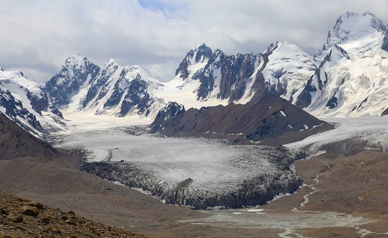
Having little time, I left this glacier unexamined, beginning my work from the upper reaches of the Kyzyl-Unet. As mentioned, this glacier is striking in the abundance of ice masses spread widely across the gorge. With a maximum length of 11.9 kilometers and a maximum width of 4.2 kilometers, its configuration seems not like a vast ice river, but something akin to a sea bay.
I spent the days of July 25th and 26th examining it. On the first of these two days, I determined the altitude of the glacier's terminus at the base of the glacier's forehead. The air temperature, measured at 3:30 PM, was 12°C. The sky was lightly covered with cirrus clouds, the atmosphere was veiled in a light haze, and a light wind blew from the south.
On the second day, with the weather worsening (almost completely cloudy, with the wind still blowing from the south and increasing haze), I, accompanied by two workers, ascended the glacier. The glacier is inaccessible directly from the forehead.
Therefore, our route detoured along the left side of the valley and further along the left coastal moraine, 4 kilometers from the end. Along this stretch, the left flank of the glacier is also inaccessible due to its steepness of 15 - 20 meters. However, the coastal moraine then adjoins it closely, merging with the lateral moraine, and here it is possible to climb onto the ice field.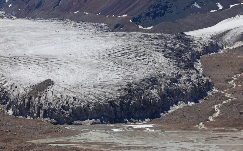
Having climbed the latter, we walked across the glacier, keeping approximately 3 kilometers from its end. Halfway between its left and right edges, the hypsothermometer indicated an altitude of 4,085 meters above sea level. The air temperature on the glacier in the morning fluctuated between 6.5 and 8°C.
It was somewhat warmer during the day. Our path was riddled with crevasses, but we maneuvered easily between them. After crossing the glacier, we emerged onto the right lateral moraine, from where we reached camp along the right bank of the valley.
The V. L. Komarov Glacier consists of three parallel branches, separated from each other by two longitudinal spurs. Each branch lies independently in a gorge, with its own cirque of nourishment. But where the dividing spurs end, they merge and form a striking width and power that dramatically sets the glacier apart from the wild mountain slopes and bleak cliffs.
The left branch of the glacier, 10 km long and 800 m wide on average, begins at a saddle on the main ridge. Loose drifts of snow slide down from it, falling steeply but without forming crevasses. The firn field is smooth and clean. From a distance, its slope appears gentle, no more than 3 - 4°.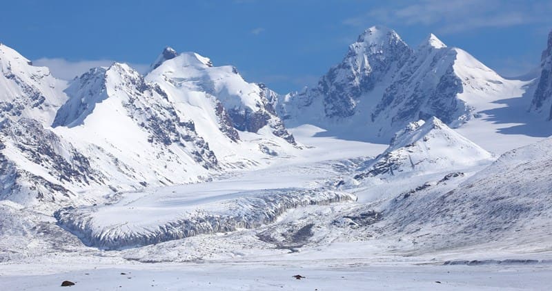
Below the split spur (we'll call it the Western spur to distinguish it from the second, Eastern spur), the branch joins with the middle one, forming a basin whose slopes are cut by wide crevasses, half-buried in snow. On the left slope of the mountains, accompanying the branch, there's a small trough filled with dense snowdrifts, which transitions below into a hanging glacier.
Its end, a low wall, stops on the slope. The branch's ridge is rougher. Shallow, narrow marginal crevasses are present. The dip ranges from 3 to 6°. There is very little moraine material on the surface. The middle branch is the longest of all. It stretches for 11.9 km and is 800 to 1000 m wide.
The cirque, initially heading west, then turns south, from where the branch emerges, maintaining the same direction. Steep, precipitous mountain faces line the upper reaches of the glacier. Masses of snow cover them wherever they can hold. The firn field is level, but as it hugs the Western Split Spur, it leaves a gap where it falls in precipitous columns and boulders.
The slope of the tsung is the same as that of the left branch. Passing the ends of the Western and Eastern Split Spurs, the glacier retreats slightly from their base, forming ravines 20 meters or more wide. Here, its sides, facing the ravine, take on a sheer appearance and, eroded by streams and thawed by the sun, transform into bizarre cliffs and peaks.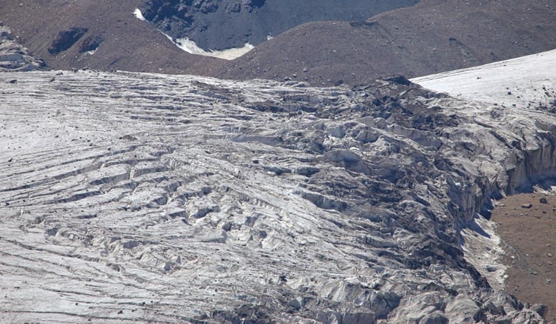
The walls are 20-30 meters high. The Split Spurs, subject to weathering, give rise to lateral moraines on the adjacent branches. These lateral moraines, merging in pairs, transform downstream into medial moraines, of which there are two on the glacier.
The left medial moraine appears as small hummocks composed of fine, loose material; the right is distinguished by its short length. The first branch is approximately the same length as the left, but wider, and originates from a high-lying trough lying on the rear wall of the cirque.
Snow falls steeply and heavily from the trough, creating a series of breaks along the slope. The firn field is as level as that of the other branches. Compared to the location at the tip of the Eastern Separate Cape, it appears 50 - 100 meters higher. The slope dips at 4 - 6°.
Like the others, the right branch has no particularly steep slopes, flowing in smooth, gentle ridges. In the area opposite the tip of the Eastern Razdelny Cape, the right branch rises as a hummock and breaks into wedges with wide transverse cracks. Crossing them is easy.
The surface of the glacier in its upper and middle sections is free of rocks; only on the right side, near the edge, do they form a dense blanket. The absence of large streams on the surface is conspicuous. The lateral moraines of the V. L. Komarov Glacier cannot be considered particularly well-developed.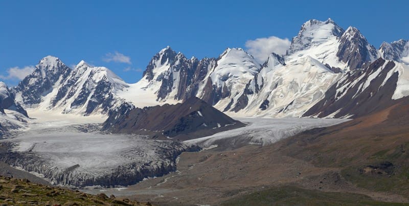
To some extent, this is due to the smooth relief of the adjacent mountain slopes, which in the lower reaches were once sculpted at a considerable height by an ancient glacier. The glacier's former, higher elevation left behind coastal moraines.
On the left side, the upper reaches of the glacier are accompanied by a single moraine, but further down, a separation becomes noticeable.
Two to three kilometers before reaching the tip, a single, powerful ridge remains isolated on the slope. Between it and the glacier there grows a spacious sloping ravine, along the thalweg of which flows. small stream. Behind it rises a pile of rock debris, stretching in a narrow ribbon along the foot of the glacier.
This is a lateral moraine, corresponding to the current state of glaciation. Nowhere does it reach such a height as to extend above the surface of the ice field. At most, it armors the slopes of the glacier, forming low piles below. On the right side, the lateral moraine has a slightly different character.
While remaining the same height, it is significantly sharper and more convex in relief. Separated from the glacier by a similar ravine, which widens closer to the end, it has preserved large masses of ice beneath it. The moraine is dissected into a series of small ridges, 15 to 20 meters high.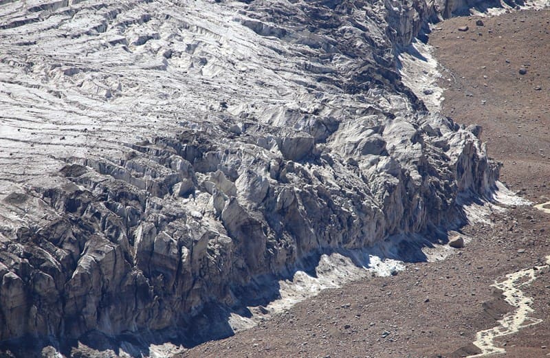
Here and there, tiny streams meander between them, turning into muddy torrents during the hot hours of the day. As all the branches join, the glacier becomes more fissured. Most of the crevasses have closed, leaving traces in the form of troughs with ridges along the edges.
On the right side, the glacier transitions into a smooth rocky ledge connecting the Eastern Separate Spur with the lateral mountain. Passing over this ledge, it plunges deeply, forming a series of giant steps with deep fissures between them. The glacier's end, tapering into a rounded triangle, is covered in mud, through which comparatively white stripes of the surface occasionally break through.
Closer to the forehead, moraine deposits are scattered sparsely. The glacier ends in a very steep, broken slope, giving way to a sheer, in places even overhanging, wall 15 - 20 meters high. The wall is scarred with vertical cracks and covered with streaks of mud running from top to bottom.
Scattered within it are the occasional stones of the internal moraine. At the foot of the wall lie blocks of white, bubbly ice, which breaks off abundantly from melted columns. Numerous streams flow from the face. In two places, at some height, gaping grottoes open up.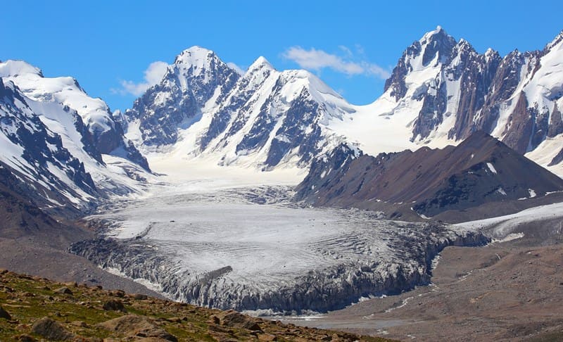
Streams cascade noisily from them. The first, to the west, falls in a single cascade of dirty water; the second falls in two cascades with clear, bright streams. The glacier's frontal moraine has two rows, with a combined length of approximately 1 km. The first row, 5 - 10 meters high, closely adjoins the face; beyond it lies a sandbar platform with streams spilling over it.
150 - 200 meters later, the second row, 10 - 15 meters high, rises; to the west, they rise higher, reaching 20 meters or more. There is no doubt that, not very long ago, the glacier reached this last row of moraines. Its new stationary state after retreat produced the first ridge, and this stationary state apparently continues to this day.
The moraine rocks consist of a wide variety of sedimentary and igneous rocks. Large boulders are rare, but cone-shaped mounds with small pebbles and clayey, powdery sediments are numerous. treams flowing from the glacier, after passing the first (recent) frontal moraines, form three powerful, muddy streams, which then spread into numerous branches, occupying a smooth, gravelly bed 300 - 500 meters wide.
The banks of the bed are often heavily saturated with water. This water, swamping the area by forming expanses of saz, comes from the lateral slopes of the mountain spurs surrounding the valley. The upper portions of these spurs bear snowfields, producing numerous streams.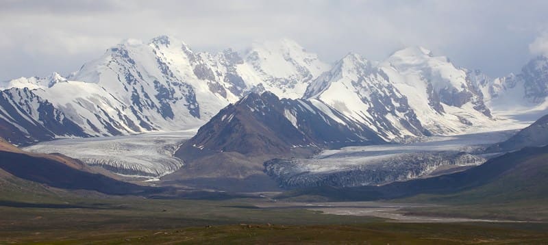
One such waterfall on the right side of the glacier is quite spectacular. Running down the slope, it forms a long, thin waterfall, some ten meters high. By collecting a significant amount of water in this manner, the streams attain impressive dimensions. If they were all concentrated in a single channel, fording such a river would be impossible.
Despite the very slight slope of the valley (only 1°), the streams flow quite swiftly. The lowest point of the V. L. Komarov Glacier's terminus lies at an altitude of 3,852 m. The upper boundary of its firn fields, according to rough estimates (angle of dip and glacier length), is at an altitude of at least 4,600 m.
The thickness of the glacier at its lower end, approximately at the line of the highest point of its forehead, is 50 - 70 m. The glaciated area within the boundaries of the military topographic survey is 24.6 km2, and with the slopes feeding the glacier, it is significantly larger.
Geographic coordinates of Komarov (Kyzylunet) Central glacier: N41°04'06 E77°23'16
Authority and photos by:
Alexander Petrov.