


![]()
Вы здесь
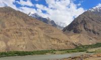
Western Tajik depression.
Tourist routes of Tajikistan.
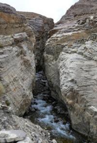
“The high mountainous shores gradually converged, the valley narrowed and appeared in front of a gorge; the rocky mountain, about which we were driving, was hammered by nature from huge stones, which pressed each other against each other with such terrible force."
A.P. Chekhov. "Duel".
Nature of Western Tajikistan.
The Western Tajik depression is located in the Khatlon region, including the Kurgan-Tyubinsk and Kulyab regions, in the southwestern part of Tajikistan. To the south of the ridges of the Gissar-Alay system is the Tajik, or Western Tajik, depression.
This part of the Pamir-Alai is represented by numerous low (1000 - 2000 meters above sea level) folded ridges, separated by longitudinal valleys of the Pyanj River tributaries. The ridges stretch from northeast to south-southwest, have a sharply asymmetric structure - long and gentle western slopes and short, steep, in places almost sheer eastern.
The relief has distinct cuesta and cuesta-like scarps. The river valleys of the depression are well developed, have wide floodplains, in most cases swampy. The Western Tajik Depression belongs to the Epigercynian platform.
An exception is the narrow strip of the eastern part of the depression, which is part of the Predamir foredeep of the Alpine geosynclinal area. The region is composed of a thick layer of Upper Cretaceous and Lower Paleogene marine sediments.
The deposits are represented by limestone, gypsum and salt. They are overlain by coarse-clastic variegated and colored continental rocks, expressed by sandstones, breccias, and conglomerates of the Neogene age.
Meso-Cenozoic deposits are collected in folds. Karst processes are developed in limestones and gypsum-bearing rocks. Of the karst relief forms, caves prevail (in the Kugitang tau ridge, Tigrovaya cave in the Khoja-Mumin salt dome in the Kulyab region, and others.).
Climate of Tajik depression is characterized by mild winters and hot summers. In the lower reaches of the Surkhandarya River, the warmest region of Central Asia is located, where average monthly temperatures are above zero all year round (the city of Termez).
Summer temperatures are high, reaching + 49 ° in Termez. Average July temperatures are +30, + 31 °, and average January temperatures reach -2, -4 °. In summer, a wind blows from Afghanistan, which brings dryness, heat, dust to the southern parts of the region.
The area is not rich in precipitation. In the lower reaches of the rivers, up to 200 mm of precipitation falls, and in the more elevated northern regions, up to 700 mm of precipitation per year. Their maximum is in the spring. There is no stable snow cover in the lower parts of the valleys.
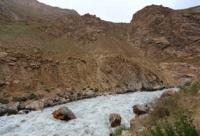
Rivers of the Western Tajik Depression.
The most significant rivers of the region are the Pyanj River and its right tributaries - Vakhsh, Kafirnigan, Kyzylsu and others, as well as the Surkhandarya, belonging to the Amu Darya basin. The rivers flow from northeast to southwest, according to the strike of the mountain ranges.
Within the mountain ranges, most rivers in their upper reaches have narrow deep valleys. On leaving the high-mountainous areas, the rivers flow through a wide valley. In the lower reaches, river beds are divided into a large number of branches.
The lowered places are swampy. Many rivers have two floods: in spring - from melting snows and in summer - from melting glaciers and alpine snows. The rivers of the region are used for irrigation.
Soils and vegetation of Western Tajik depression.
In the western parts of the region, takyr soils with areas of gypsum sierozem are developed (Shirbad valley, lower reaches of the Vakhsh valley). In some places, there are hilly sands with individual dunes, which are found mainly in the lower reaches of the Surkhandarya and on the terraces of the Amu Darya.
In the valleys of the Amu Darya, Surkhandarya, Pyandzha, Kafirnigan, Vakhsh, Kyzylsu rivers, the soil cover is represented by alluvial meadow and saz and meadow soils, which are saline in places in the lower reaches of the rivers.
In the western and southern parts of the Shirbad valley, in the interfluves of Surkhandarya and Kafirnigan, as well as Kafirnigan and Vakhsh, gypsum serozem is developed. In more elevated places, they turn into light gray soils on loess-like sediments.
Common sierozem soils, which are usually saline in the western part, are characteristic of the foothills. At an altitude of 800 - 900 meters above sea level, they turn into dark gray soils. In the low mountains, especially in the southwestern part, the soil cover in most cases is absent.
In some places, it is represented by thin rubble gypsum sierozem, which are developed on coarse parent rocks (marls, sandstones, clay shales, limestones). In the southeastern part, light gravelly-loamy sierozem is developed, passing higher into ordinary and dark sierozem.
Serozem soils (takyr, light, ordinary, serozem-meadow), subject to irrigation, are used for growing cotton and other crops. The vegetation cover of both plains and hilly watersheds is dominated by sedge-bluegrass communities (Carex pachystylis and Poa bulbosa), which are classified as low-grass semi-savannas.
This also includes one-year-old ephemera: poppy (Papaver pauoninum), astragalus (Astragalus rytilobus), beetroot, fenugreek, etc. and etc. In the river valleys, along the salt marshes, there is developed arboreal and shrub vegetation, consisting of a comb (Tamarix ramesissima), jida (Elaeagnus angustifolia), petta (Populus pruinosa).
In the grass cover there are large grains: kalam, uruk. From the animal world, the following are widespread: wolf, fox, red-tailed gerbil, mole vole, small jerboa, hyena, Afghan vole. In tugai there are: tiger, tugai deer, jungle cat house, etc., many birds.
Geographic coordinates of Western Tajik depression: N37 ° 57'29.93 "E69 ° 13'07.98"
Authority:
http://big-archive.ru
Photos by
Alexander Petrov.