


![]()
Вы здесь
Aktau ridge in Central Tien Shan.

Mountain ranges of Central Tien-Shan.
"The land moved to the place of the sea and the sea to the place of land in ancient times..., only a select few can delve into these phenomena."
Abu Reyhan Muhammad ibn Ahmed al Biruni. Khorezm, 973. - Gazna, 1048.
Climbing in Aktau ridge in Central Tien-Shan.
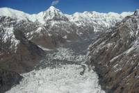
The Aktau ridge is located in the Central Tien-Shan in the north of the Northern Kokshaal-Too ridge in the Ak-Suu district of the Issyk-Kul region. From the mountain range, where the Northern Kokshaal-Too connects with the Meridional ridge, from the northern slopes of the Voennyi Topografov peak, 6873 meters above sea level, a ridge departs to the north, which was named Aktau.
From the north, the borders of the ridge are the South Inylchek glacier with a length of 62 kilometers, from the east, the upper reaches of the glacier of the same name. From the west, the Aktau ridge borders on the Zvezdochka glacier with a length of 17 kilometers, which stretches from the Chonteren pass with a height of 5488 meters above sea level and the Vysoky pass.
The Chonteren pass is located in the crest of the Northern Kokshaal-Too ridge. The length of the Aktau ridge from northeast to southwest is 14 kilometers, the greatest width of the ridge in the central part is 8 kilometers.
The dominant peak of Aktau is the Aktau peak, 6181 meters above sea level, located in the central part, in the crest of the ridge. Between the Voennyh Topografov peak and the northern part of the Aktau ridge, there is a Vysokiy pass with a height of 5730 meters above sea level.
In the northwestern part of the Aktau ridge, at the confluence of the Zvezdochka and South Inylchek glaciers, there is the South Inylchek seasonal mountaineering camp. The slopes of Aktau within the height of 4700 - 6100 meters above sea level are covered with longitudinal stripes, similar to avalanche trenches, on the protruding parts there were huge snow "caps", something in the form of "ice mushrooms", as if running down in rows from top to bottom.
The appearance of the slope was somewhat reminiscent of a branched Tien Shan spruce covered with snow flakes; this snowy relief is called “spruce snow”. Unfortunately, on the crest of the Aktau ridge, where such a relief is better developed, the slopes are very steep and avalanche-dangerous.
For the first time he reached the headwaters of the South Inylchek glacier and photographed the eastern slopes of the Aktau ridge by M. A. Demchenko in 1932. There is a strict pattern in the distribution of sites in the Aktau ridge, occupied by “spruce snow”: they are located on the eastern slope of the ridge, opposite the depressions and saddles of the Meridional ridge.
“Spruce snow” refers to outgrowths in the form of a giant rime, considering that these rare forms of snow relief are most likely associated with the local transfer of warm air masses from the south, southeast, through deep depressions of the outer chains into the circus of the South Inylchek glacier.
The aggregate of the snow relief, considered under the conditional name "spruce snow", can arise under the following circumstances: warm or warmer air masses in relation to the local air flow through the depressions of the row of opposite ridges.
Such an air flow rests against a snowy slope and rushes upwards along it. In the upper, ridge part of the slope, the air cools and precipitates in the form of frost. This process of advection of moist warm air with a temperature higher than the temperature of the snow surface is well known.
Snowflakes, settling on the cold surface of the slope, crumble over it.
Geographic coordinates of the Aktau ridge: N42 ° 05'50.23 "E80 ° 10'02.53"
Authority:
Alexander Petrov.
V. Ratsek. “Forms of“ spruce snow ”on Tengri tag.” “Conquered peaks». 1973 – 1974. Thought Publishing House, 1976.
Photos by
Vladimir Serbenko.