


![]()
Вы здесь
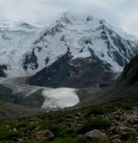
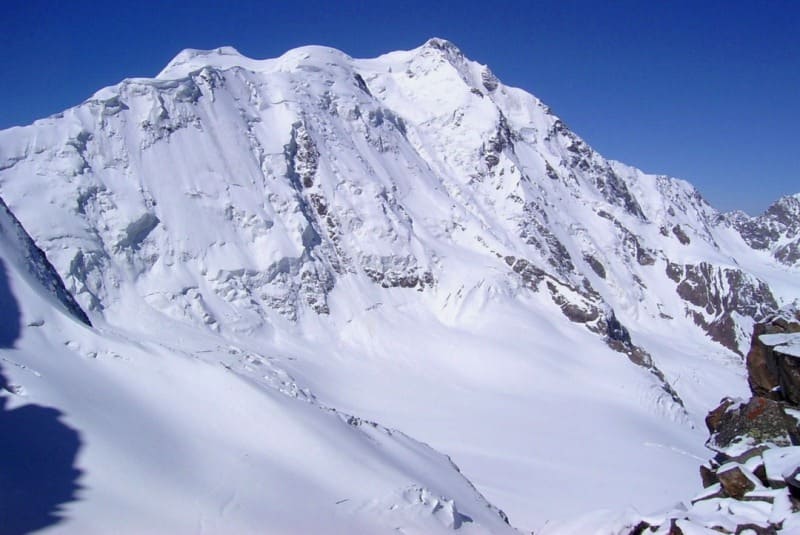
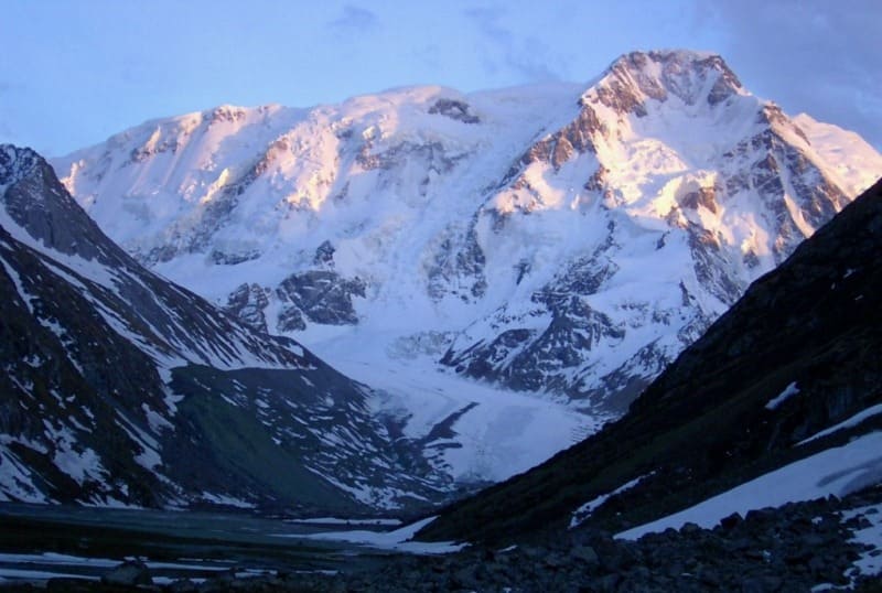
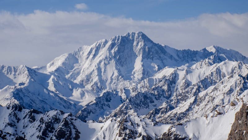
Karakol Peak.
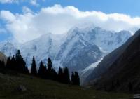
Climbing in Terskey-Ala-Too mountains.
“What does mountaineering give to an individual? - asked a prominent western climber half a century ago and answered like this: - He returns us to nature, that element with which most of us have lost a direct connection. The aspiration upward, boundless, spontaneous - doesn't it take us, as on magic wings, somewhere far away from the usual level, and along with it from ordinary thoughts?"
Evgeny Abalakov.
Climbing Karakolsky peak in Terskey Ala-Too ridge.
Karakol summit with a height of 5280 meters above sea level is first highest mark of Terskey Ala-Too ridge, located in main ridge, in upper reaches Karakol river, in Ak-Suu region in east of Issyk-Kul region.
On a topographic map in scale 1: 200,000, the height of the summit is indicated as 5216 meters above sea level. The summit is located 36 kilometers (in a straight line) to the south and slightly east of the city of Karakol, the administrative center of the Issyk-Kul region.
A very picturesque peak, it is popular among climbers as the highest peak of the ridge and a variety of combined routes, including mainly rocky ones. The top is in the shape of a pyramid. Glaciers descend from the top to the north: Karakol East with a length of 5 kilometers and Karakol West with a length of 3.8 km.
From the western slope descends the Bordu glacier, 7.3 kilometers long. The Bordu glacier, 2 kilometers after it leaves the slopes of the Karakol massif, turns to the south. The tongue of the glacier is located in the Bordu valley at an altitude of 3592 meters above sea level. Glaciers: Ailanysh, East Kichi-Bordu, On-Ter, Choi-Bordu, Kel-Ter also belong to the Karakol peak massif.
The Elephant Peak is located between the Karakol and Dzhigit peaks in the crest of the ridge. Elephant Peak, 4726 meters above sea level, is located 3.7 kilometers east of Karakol Peak. 5.9 kilometers to the north-east is the Dzhigit peak 5020 meters above sea level.
Oguz-Bashi peak with a height of 4852 meters above sea level is located 3.8 kilometers south-west of the Karakol peak.
History of ascents to Karakol peak.
A.N. Letavet continued the survey of the Kuylyu Ridge, begun in 1936. The expedition organized by him in 1937 included several experienced mountain climbers-athletes; the group had to climb the peaks discovered in 1936.
Here is how A.N. Letavet in summer of 1936:
“The Karakol peak is an ice-bound trapezoidal peak. We could talk about two options for ascent:
1) cross a very steep ice wall in its lower part to the east of the summit and then go to the summit along a rather long ice ridge and,
2) climb from the northwest along a rather difficult glacier and rocky route straight to the top.
The first option seemed to us then more realistic to reach the summit, albeit more time-consuming to implement. The assault on the northern Karakol wall turned out to be quite difficult. The movement of the two threes was rather slow.
The icy slopes were covered with only a thin layer of snow. Therefore, almost the entire ascent had to be done with a belay with the help of ice hooks. The weather was unstable - it was clearing, and below on the glacier it was possible to clearly see the tents we had left, then the fog was so thick that it was difficult to distinguish the climbers of our band.
We spent the night in the middle of the wall, in a small crevice, on a miniature platform, strengthening our tents with ice hooks. It was, of course, not a very comfortable lodging for the night. We were worried about the danger of a collapse of the huge ice blocks that could be seen above us.
The ascent along the ice wall took almost the entire next day, and only in the evening, finally, we managed to get out to the long-awaited ridge of the topmails. It was a real knife blade, though heavily serrated. An equally steep wall fell to the south, with the only difference that for the most part it was rocky.
Below, on the southern side, one of the glaciers, which gave rise to the Kuylyu River, was visible, covered with many cracks. In the distance, they appeared in the breakthroughs of the clouds, then again the pointed peaks of the Kuylyu ridge disappeared... the height was 5000 m;
Thus, in two days, a climb to 1300 m was completed. With great difficulty, on the very ridge, we managed to prepare a safe area for both of our tents. There was hardly more "comfort" here than on the previous night, on the wall.
The ridge leading to the top did not bode well. Deciding that "the morning is wiser than the evening," we went to bed. This time the morning was not "wiser" than the evening. Reconnaissance showed that the way to the top could take two more days, since the ridge was interrupted in several places by deep gaps, the circumvention of which could present significant difficulties.
The physical condition of the participants was also affected by the lack of training - this was the first ascent of the season. We decided to turn and go down along the path of our ascent. Although the Karakol peak was not defeated this time, we were satisfied, for the crossing of the northern wall of the Karakol peak in itself was a rather serious sporting achievement."
In the summer of 1937, even before the start of the main campaign, during the preparation of the caravan in Przhevalsk, our group (Popov, Beloglazov, Ratsek) managed to climb the Karakol peak (5270 m). The ascent was made from the northwest, along the route that our group neglected in 1936.
A participant in this ascent, the Kyrgyz climber Ratsek later, in 1939, led the ascent to another remarkable peak of this ridge - Dzhigit peak. Together with him, this peak was won by Kemarsky and Berezin.
The first ascent to the summit was made on August 3, 1937, of the 4B category of difficulty, together with Moscow climbers Nikolai Popov, Grigory Beloglazov, climber from Bishkek V. Ratsek, local climber Kasymaly Bagazinov did not participate in the ascent due to illness.
In 1958, four instructors-climbers of the Burevestnik DSO under the leadership of A.F. Kuznetsov made an ascent to the Karakol peak along the north-western ridge and for the first time traversed the Karakol peak with a descent along the northeastern ridge before the ascent to Dzhigit.
Western Ridge of Karacol Peak (5,281 m, 4B).
Start off from the On-Tor glacier bivouac and head southwest towards Dzheti-Oguz pass. Before arriving at the col, you must go over a steep ice wall; leave early to avoid rock slides. Once on the pass, head east and go up along the gentle snow slope to the ridge in the direction of the shoulder, which is ideal for bivouacking (4,500 m, 2 hours from the pass).
From here you can go up to the top and descend again, leaving behind your camp gear. The view of the surrounding mountains and Lake Issyk Kul is simply fantastic. The snow and ice ridge continues up to the summit; the route is steep only for about 100 meters in the middle, where you will have to climb and need ice screws.
Then cross over easy gullies up to the top. The descent, with rappels in the steeper parts, takes from two to three hours.
Mt. Karacolskiy North face. "Elephant's Trunk" on Slonenok (Little Elephant).
Peak (4,726 m, 4A) From the Karakol valley base camp, go southwards in the On-Tor valley. Continue for the first hour in a lovely forest of the typical Tien-Shan pines which are up to forty meters high, and then proceed for two hours through meadows covered with edelweiss in the direction of the On-Tor glacier.
The entire route is dominated by the forbidding northern face of Karacol Peak (5,281 m), which is imprisoned in the ice. When you are almost at the end of the glacier, turn right. Then you have to look for the passage on the moraine that will take you up to the top of the glacier.
Continue for about an hour on the plateau until you reach a little moraine opposite Karacol Peak where you can set up camp. This is an excellent lockout over the entire region. East of Karakol are Slonenok (Little Elephant, 4,726 m), Festivalnaya (4,500 m) and the mountain top that closes off the valley, Dzhigit (5,170 m), with its two famous northern and northwestern faces.
Mt. Slonenok owes its name to its shape, which vaguely resembles an elephants profile. Here there are many fine routes: Perednjaya Lapa (Front Paw) (the middle of the northwestern face, 5A.) and Zadnjaya Lapa (Back Paw) (the northwestern spur) are a perfect combination of elegant climbs on ice and rock; they are difficult but can be done in one day.
The easiest route, Khvost Slona (Elephant's Tail, 3B), is not recommendable because of the extremely dangerous avalanches. The classical route is the eastern ridge, Khobot Slona (Elephant's Trunk). From the bivouac on the On-Tor glacier it takes about an hour to arrive at the starting point, on the left-hand side of the mountain.
The first part is the most difficult. It begins with a climb up rock that is necessary in order to avoid the icefall to the right. This is a 200-300-meter climb up steep rock; you need a hammer, pitons, a helmet and rope. You come out onto a broad slope with a 25-30° incline and continue in the direction of the col between Mt. Slonenok and Festivalnaya.
In the summer this slope is usually covered with a lot of snow and the path is a sort of trench, so that you must use an ice axe as an aid and keep to the left to avoid the risk of the frequent snow-slides coming from the northwestern face of the group.
The route takes three or four hours up to the pass, depending on the condition of the snow. From the pass, go up towards the top via the steep snow and ice ridge called the Trunk. You will need ice screws, crampons, rope and ice axes; it is advisable to use two ice axes per person.
It takes about four hours to reach the top from the pass. From here the view is breathtaking: the On-Tor valley, the northern face of Karacolskiy, the Oguz-Bashi group, the western ridge of Dzhigit and, in the distance to : the north, Lake Issyk-Kul if the visibility is good, while to the south you can see, amidst the haze, the grandiose pyramid of Khan-Tengri.
You go down by the same route by rappelling (3 - 4 hours to the glacier, a half hour to the bivouac).
Geographic coordinates of Karakol peak: N42 ° 10'22.52 "E78 ° 27'55.37"


Authority:
Alexander Petrov.
Zatulovsky D.M. "On the glaciers and peaks of Central Asia." OGIZ, State Publishing House of Geographical Literature. 1948.
Letavet A.A. "Ten journeys in the mountains of Central Asia". Geografgiz, 1949.
http://mountains.tos.ru
Photos by
Sergei Pyshnenko, Bishkek city.
http://karakol.kg