


![]()
Вы здесь
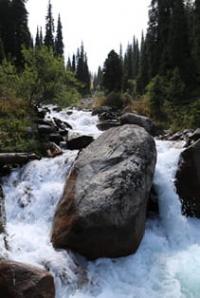
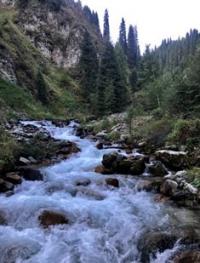
Narynkol river.
Travel along rivers of Central Tien-Shan mountains.
“As soon as man seeks to penetrate the secrets of nature - in which nothing is secret and it is but a question of seeing - he realizes that the simple produces the supernatural”
Honore de Balzac.
Rivers of Central Tien-Shan mountains.
Narynkol River is a right tributary of Bayankol River, its sources are located on the northern slopes of Meridional Range in Narynkol District of Almaty Region.
The last right tributary of the Bayankol River before the mouth is the Narynkol River with a length of 27.3 kilometers. This is the longest tributary of the Bayankol River, along which the state border between the Republic of China and the Republic of Kazakhstan passes. It should be noted that the right tributaries of the Narynkol are located in the Republic of China, the left tributaries in the Republic of Kazakhstan.
After the confluence of two tributaries at an altitude of 3077 m. a. s. l., the main channel of the Narynkol River is formed. The left source is the most abundant, it originates from a group of four glaciers located on the northern and eastern slopes of the Meridional Range and five lakes.
The upper border of the glaciers is located at an altitum. a. s. l. On the left, the Narynkol River receives 6 tributaries, three of these tributaries have names, the rest are unnamed. The border of the forest in the gorge of the Narynkol River ends at an altitude of 2955 m. a. s. l.
The mouth of the Narynkol River is located in the northwestern part of the Narynkol village at an altitude of 1808 m. a. s. l.
Geographic coordinates of Narynkol River: N42°37'20 E80°09'51
The lakes at the headwaters of the river are located on the eastern slope in the upper reaches of a narrow gorge, two of them are large and three are small.
Lake Narynkol Verkhnee.
This lake is located at an altitude of 3548 m. a. s. l. at the end of a 1.1 km long moraine that descends from the southwestern slope of a closed gorge, from the crest of a ridge. The highest point of the ridge is located at an altitude of 4227 m. a. s. l. In the depths of the moraine, there is a glacier that feeds the Upper Lake Narynkol.
The length of the lake from southwest to northeast is 590 meters, the greatest width in the central part is 380 meters. The lake area is 156379 sq. m., the perimeter of the lake is 1675 meters. A stream flows out of the eastern part of the lake, which after 400 meters flows into the Lower Lake Narynkol located at an altitude of 3412 m. a. s. l.
Geographic coordinates of Upper Narynkol lake: N42°30'58 E80°12'11
Lake Narynkol Lower.
The lake is located at an altitude of 3412 m. a. s. l., located in the upper reaches of the left sources of the Narynkol River. The lake is located 400 meters east of the Narynkol Upper Lake. On the western side of the lake is the mouth of a stream that flows out of the Upper Lake.
A stream overflows from the southwestern part of the lake and after 1 kilometer flows from the left into the left source of the Narynkol River. Two small moraine lakes are located 240 meters north-east of the lake. The highest point of the ridge ridge, in the vicinity, is located at an altitude of 4227 m. a. s. l.
In the depths of the moraine lies a glacier that feeds the Lower Lake Narynkol. The length of the lake from southwest to northeast is 266 meters, the greatest width in the central part is 190 meters. The area of the lake is 39005 sq. m., the perimeter of the lake is 835 meters.
Geographic coordinates of Nizhny Narynkol lake: N42°30'58 E80°12'11
The left source, 4.1 kilometers long, originates from glaciers located on the northern slopes of the Meridional Ridge. The highest point of the glaciers in the eastern part of the ridge located at an altitude of 4099 m. a. s. l. The state border between the Republic of Kazakhstan and the Republic of China runs along the left source. After the confluence of the left source with the right source, the river is called Narynkol.
First left unnamed tributary of Narynkol River.
2.6 kilometers after the formation of the main channel, an unnamed tributary with a length of 3.6 kilometers flows into the Narynkol on the left. The sources of the tributary begin from two small glaciers on the northern slope of the Meridional Ridge.
Geographic coordinates of first left tributary of Narynkol River: N42°32'59 E80°11'58
Second left unnamed tributary of Narynkol River.
2.2 kilometers after the first tributary, a second unnamed tributary with a length of 3.5 kilometers flows into the left. The sources of the tributary begin on the northern slope of the Meridional Range at an altitude of 3396 m. a. s. l. The mouth of the tributary is located at an altitude of 2738 m. a. s. l.
Geographic coordinates of second left tributary of Narynkol River: N42°33'35 E80°11'06
Taldysay river
3 kilometers after the confluence of the second unnamed tributary into the Narynkol, the Taldysai River, 7.4 kilometers long, flows into the left. The sources of the Taldisay River are located at an altitude of 3280 meters above sea level on the northern slope of the Meridional Range.
The mouth of the river is located at an altitude of 2,416 m. a. s. l. Starting from an altitude of 2938 meters above sea level to the mouth of the Taldysai river flows in the forest zone.
Geographic coordinates of Taldysai River: N42°34'14 E80°10'26
Kuanyshbai river.
1.1 kilometers after the confluence of the Taldysai River into the Narynkol, the Kuanyshbai River flows into the left length of 4.3 kilometers. The sources of the Taldysay River are located on the northern slope of the Meridional Range.
Geographic coordinates of Kuanyshbai River: N42°36'07 E80°10'34
Third unnamed tributary of Narynkol River.
2.5 kilometers after the confluence of the Kuanyshbay tributary, the third unnamed tributary with a length of 4.6 kilometers flows into the Narynkol on the left. The source of the third unnamed tributary begins at an altitude of 3138 m. a. s. l. The mouth of the tributary is located at an altitude of 2213 m. a. s. l.
Geographic coordinates of third, left unnamed tributary of Narynkol River: N42°36'59 E80°09'26
Sulasu river.
2 kilometers after the confluence of the third unnamed tributary, the 7.5 kilometers long Sulasu River flows into the left. The headwaters of Sulasu are located at an altitude of 3253 m. a. s. l.on the northern slope of the Meridional Range.
At the headwaters of Sulasu, a little to the west, a mountain 3724.9 m. a. s. l. dominates.
The Sulasu estuary is located at an altitude of 213 m. a. s. l. 1.5 kilometers before the mouth, the river receives a tributary from the left, which originates from the eastern side of the Koyshebulak pass with a height of 2949 m. a. s. l.
Geographic coordinates of Sulasu River: N42°38'21 E80°09'24
Authority and photos by
Alexander Petrov.